Bele vode / Rio Bianco - Visoka Bela Špica / Cima Alta di Riobianco
Starting point: Bele vode / Rio Bianco (980 m)
Starting point Lat/Lon: 46.4096°N 13.5357°E 
Time of walking: 5 h
Difficulty: rock climbing ascent
Difficulty of skiing: no data
Altitude difference: 1277 m
Altitude difference (by path): 1277 m
Map: Alpi Giulie Tarvisiano - št.019, 1: 25.000
Access to starting point:
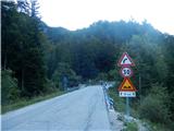
A) From Kranjska Gora over the border crossing Rateče we drive to Trbiž / Tarvisio. In Trbiž we continue left in the direction of Bovec and we follow the road to the crossroad near the lake Rabeljsko jezero. Here we continue right in the direction of Nevejski preval / Sella Nevea. This road which is mostly ascending we follow about 2 - 3 km to the bridge, where at the left turn road crosses the stream Bele vode / Rio Bianco. On the left side of the road, we will notice few smaller parking spots, larger macadam is situated on gravel below bridge, where there is also starting point for path on Jerebica.
B) From Bovec, we drive to the border crossing Predel, from which we descend on the Italian side. At lake Rabeljsko jezero we come to a crossroad, where we continue left in the direction of Nevejski preval / Sella Nevea (straight runs road in Rabelj / Cave di Predil and Trbiž). Further, we follow the description above.
Path description:
At the beginning of the path (in the direction of Sella Nevea - this is before the bridge on the right side of the road) stands information board and signposts for more destinations. We start walking on a comfortable path - Italian sign number 625, through the forest on the right side of the stream Rio Bianco, by which we are slightly ascending for quite some time. After that stream, the valley Bele vode (Italian Rio Bianco) got its name. After that, the path few times crosses a riverbed of a stream, where occasionally in individual small pools we can also refresh ourselves. Later, the path turns a little to the left and then a little to the right, shorter hairpin ascent follows to the hut Brunner (1432 meters), former hunting cottage of King of Saxony, to where we get into good hour of walking. In front of the hut are settled bench for a rest, due to the forest there isn't much view. At the hut, where there is also a crossing (left from it leads e.g.. demanding path of King of Saxony towards the mountain hut Corsi), we continue behind the mountain hut straight ahead on the path 625 in the direction of bivouac Gorizia. After that, the path soon comes out of the forest and is ascending by the riverbed of the stream through dwarf pines. In the middle of slopes, the path turns to the left and it brings us to a crossing, where we continue on the left path towards the bivouac Gorizia, the path branches off to the right towards the notch Bele vode (Italian Forca di Rio Bianco). Dwarf pines then soon ends, and the path starts ascending a little steeper and passes into rocky terrain with grass. When the path again flattens a little, we notice a caption on big rock by path: Bivacco, points us left towards the bivouac (there are two) to which we have less than 100 meters, and right or ahead runs direct path towards the notch Krniška škrbina (Italian Forcella del Vallone), which is situated between Trbiška Krniška špica (on the right) and Male Špice (on the left), where runs known path Pot stoletnice.
From bivouacs Gorizia (1950 meters) a view opens up on magnificent northern wall of Visoka Bela špica, but northern accesses demand alpinistic knowledge (climbing from grade IV and upwards). Because mountain has easier access from the south side, after bivouacs we go upwards, at first on the scree, after that over crumbly gravel terrain and through easier rocky section all the way to the top of notch named Zgornja škrbina Belega potoka (Italian Forcella Alta di Riobianco) or to a smaller saddle between Visoka Bela Špica and Male Špice on the right, where ends or starts path Pot Stoletnice. From bivouacs further path isn't marked, but it is relatively easy to follow, we have to look for the best passages among gravel, dispersed rocks and smaller gully, but all the time we have to go upwards towards the notch, because after bivouacs there are also some turn-offs to the left, for previously mentioned northern climbing approaches. From bivouacs to the notch Zgornja škrbina or saddle is less than half an hour. On the saddle, it is good to take some time and from below look the route of the approach, even though the big outside corner or a natural rocky groove, logically show the direction of ascent.
With our climbing we start about 10 meters lower, and right south from the saddle, on more gentle and comfortable slope approx 20 meters upwards all the way to leaning shoulder and narrow rocky passage, over which we go to the left towards the main part part of groove. The difficulty of ascent then quickly reaches and exceeds I. grade, and follows even harder continuation below main rounded part and passage over it, where mountain wall becomes very steep (approx II - III. grade, in shorter part maybe also III.), easier is to the left in gable of rocky groove. By general grade and because of bigger exposure is right groove over main rounded part of the outside corner harder, but in this part are two anchor or belay points, which we can especially on return use for a descent.
The last part of climbing below exit on a ridge, is a little easier, but it should be noted, that in this part on rocks and ledges there is some more gravel and stones, therefore risk of slipping increases. From the bottom shoulder over outside corner or groove upwards to the exit on a ridge is approx 80 meters of quite demanding wall, which in general offers very good holds, but ascent to the end demands complete concentration. Before we exit on a ridge, on the right it is good to remember also upper anchor for a descent by rope, which is situated right below last green lane of dwarf pines.
When we climbed over rocky outside corner and exit on a ridge, becomes mountain from this - south side much nicer for access, to the top we need only a little less than 15 min, on more or less undemanding terrain.
Visoka Bela Špica has on the summit longer less steep upper ridge, which isn't that narrow, as you would otherwise have assumed, if we observe it from far, on the summit is located box with an inscription book, otherwise are from the peak far around wonderful views on Viš group of mountains, Kanin mountains and on our western Julian Alps around Mangart.
Descent we make on the same path as ascent, in doing so over rocky outside corner to a saddle it is best to use rope and appropriate belaying for descending. In time of our visit (in August 2017) there were settled four anchors for abseil, so theoretically it is enough 40 meters of rope. For free climbing downwards you need quite some knowledge, appropriate experiences, so first consider, if you are capable of doing it alone, otherwise the belaying on the main, most difficult part of the wall is almost urgent also for average alpinists.
When we descended back on a saddle or notch Zgornja škrbina, we can return back to bivouacs or on the path Pot Stoletnice (secured, interesting and panoramic) we continue on notch Krniška škrbina and from there we descend towards bivouacs.
The ascent from the notch on Visoka Bela špica is the most appropriate in the summer months, in cold days we have also take into account the fact, that southwestern outside corner is in the morning still in the shade and that a rock is at an early hour still relatively cold. But at the end the summarize the essence: ascent on the mountain from the saddle, especially descent require appropriate alpinistic knowledge and technical belaying.
Pictures:
 1
1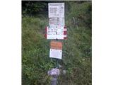 2
2 3
3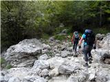 4
4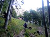 5
5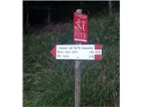 6
6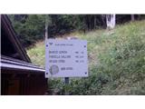 7
7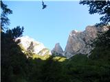 8
8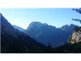 9
9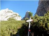 10
10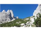 11
11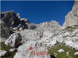 12
12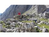 13
13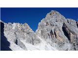 14
14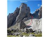 15
15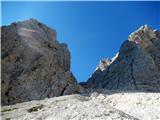 16
16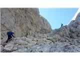 17
17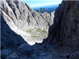 18
18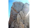 19
19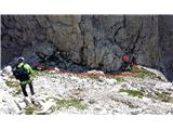 20
20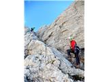 21
21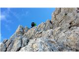 22
22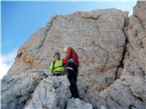 23
23 24
24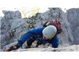 25
25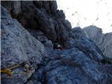 26
26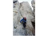 27
27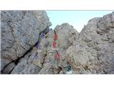 28
28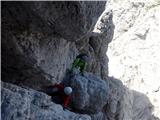 29
29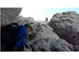 30
30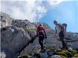 31
31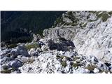 32
32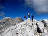 33
33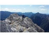 34
34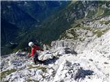 35
35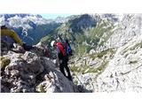 36
36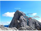 37
37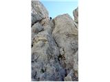 38
38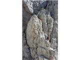 39
39