Rifugio Bai de Dones - Rifugio Scoiattoli (on ski track)
Starting point: Rifugio Bai de Dones (1889 m)
Starting point Lat/Lon: 46.5189°N 12.0379°E 
Path name: on ski track
Time of walking: 1 h 15 min
Difficulty: easy unmarked way
Difficulty of skiing: no data
Altitude difference: 366 m
Altitude difference (by path): 375 m
Map: Tabacco 03, 1:25.000
Access to starting point:
A) From Kranjska Gora over Korensko sedlo to Austria, where at the first larger crossroad, we continue left towards Podklošter / Arnoldstein and Trbiž / Tarvisio. By the end of the settlement Podklošter signs for Šmohor / Hermagor point us to the right on a regional road, on which past the mentioned settlement we drive to the end of the valley Gailtal, or more precisely to the settlement Kötschach-Mauthen, where we turn right towards the settlement Oberdrauburg. The path ahead leads us over an Alpine mountain pass Gailbergsattel (982 meters), after which we descend into the mentioned settlement. After we cross the bridge through river Drau, we continue left towards the settlement Lienz. In the main roundabout in Lienz we continue "left" in the direction of the settlement Sillian and Italy. Further, we cross the border between Austria and Italy, and we follow the main road to the settlement Dobbiaco / Toblach, where we turn left towards Cortina d'Ampezzo. When we get into Cortina d'Ampezzo, we follow the signs for Alpine mountain pass Passo Falzarego. The road above Cortina d'Ampezzo starts ascending steeper, and we follow it for quite some time, more precisely to the spot, where just before a sharp right turn we go left on a road which we quickly get to a large parking lot at the mountain hut Rifugio Bai de Dones. From Kranjska Gora to the starting point is 208 km.
B) From Kranjska gora over a border crossing Rateče to Trbiž / Tarvisio and further on a highway towards Videm / Udine. We leave the highway at settlement Tolmezzo, from where we continue driving towards the settlement Ampezzo and forward towards Alpine mountain pass Passo della Mauria (1298 meters). The road then starts descending and brings us into a valley Cadore, where we continue right towards the settlement Auronzo di Cadore. At the next crossroads, we follow the signs for Cortina d'Ampezzo. When we get into Cortina d'Ampezzo, we follow the signs for Alpine mountain pass Passo Falzarego. The road above Cortina d'Ampezzo starts ascending steeper, and we follow it for quite some time, more precisely to the spot, where just before a sharp right turn we go left on a road which we quickly get to a large parking lot at the mountain hut Rifugio Bai de Dones. From Kranjska Gora to the starting point is 198 km.
C) From Nova Gorica, we drive to Italy and drive forward on a highway to the settlement Portogruaro, where at the highway junction we turn in the direction of Belluno. We follow the highway to its end (we don't turn in the direction towards Belluno), and then we continue driving towards Cortina d'Ampezzo. When we get into Cortina d'Ampezzo, we follow the signs for Alpine mountain pass Passo Falzarego. The road above Cortina d'Ampezzo starts ascending steeper, and we follow it for quite some time, more precisely to the spot, where just before a sharp right turn we go left on a road which we quickly get to a large parking lot at the mountain hut Rifugio Bai de Dones. From the border crossing to the starting point, there is approximately 230 km.
Path description:
Left from the bottom cableway station, which leads to the hut Rifugio Scoiattoli, we will notice a macadam road which starts ascending on a ski track. We go on the mentioned road which soon turns right and changes into a steep cart track (transport road for the purpose of the ski slope), which is ascending on a ski track. After few minutes of a steep ascent cart track for some time flattens and brings us into a smaller valley, where we cross a stream. Cart track, which is still ascending on a ski track, again becomes a little steeper and higher turns slightly towards the right, where brings us to the bottom cableway station, which leads to the hut Rifugio Averau. Here the path, from which beautiful views opening up on Averau and back towards the peaks Lagazuoi Piccolo, Cima Bos, Cima Falzarego and Tofana di Rozes, for some time flattens and a little higher joins wider, but steep macadam road. The road is for some time moderately to steeply ascending, and then it brings us to the smaller crossroad, where we continue left in the direction of the mountain hut Rifugio Scoiattoli (straight or slightly right Rifugio Averau and Rifugio Nuvolau), which we reach in few minutes of additional walking.
Pictures:
 1
1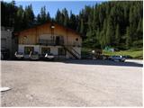 2
2 3
3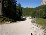 4
4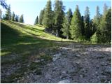 5
5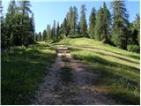 6
6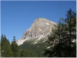 7
7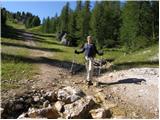 8
8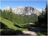 9
9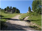 10
10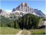 11
11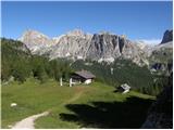 12
12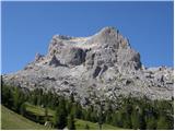 13
13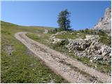 14
14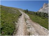 15
15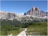 16
16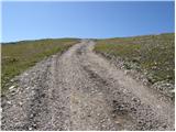 17
17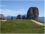 18
18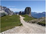 19
19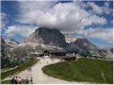 20
20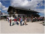 21
21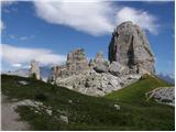 22
22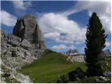 23
23