The Kot valley - Macesnovec
Starting point: The Kot valley (950 m)
Starting point Lat/Lon: 46.4157°N 13.8977°E 
Time of walking: 3 h 30 min
Difficulty: difficult unmarked way
Difficulty of skiing: more demanding
Altitude difference: 976 m
Altitude difference (by path): 980 m
Map: TNP 1:50.000
Access to starting point:
From Mojstrana we drive on the road which leads in Radovna, before the road starts descending towards Radovna and Krma, we turn right on a turn-off of the forest road into a valley Kot (marked with a signpost). On narrow, well maintained forest road we drive to the parking lot on Lengarjev rovt.
Path description:
From the parking lot at first we quite some time walk on a marked path which leads to mountan hut Staničeva koča. The path is in parts slightly exposed, on the most exposed spots secured with some iron spikes and two steel cables.
When we come to a well, which we notice on the left side by the path (a short gutter is placed there, that we can pour water, next to a smaller rock caption "drži čistočo" (keep it clean)), we need to pay attention: about 50 meters ahead from the marked path, unmarked path branches off left upwards, namely just before a marked path turns right through torrent gully.
Unmarked, but well visible footpath quite steeply ascends towards the large scree, and soon it splits into two - right (upper) and left (bottom). Both footpaths higher on the path again join. Bottom (left) is ascending quite steadily over the scree and among dwarf pines (often marked with cairns), upper (right) at first quite steeply ascends on the scree, and then leads in light ascent, without large distinct ascents to the spot, where both paths join again. The path from here further runs mostly very steeply on a slope, in thin larch forest and dwarf pines on quite some spots is exposed (dangerous for slipping), but all the time easy to follow. A little below the summit, the path passes over the ridge on the other side (so far we were on a slope above Kot, and from there further on a slope above Krma). Right below the summit dwarf pines entirely replace until then prevailing larches. The peak itself is rocky and grassy.
Pictures:
 1
1 2
2 3
3 4
4 5
5 6
6 7
7 8
8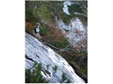 9
9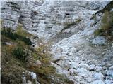 10
10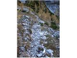 11
11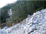 12
12 13
13