Murijeva planina below Mlinarjevo sedlo - Na Križu (Kokrska Kočna) (on NW ridge on Kočna or peak Na Križu)
Starting point: Murijeva planina below Mlinarjevo sedlo (1200 m)
Path name: on NW ridge on Kočna or peak Na Križu
Time of walking: 8 h
Difficulty: rock climbing ascent
Difficulty of skiing: no data
Altitude difference: 1284 m
Altitude difference (by path): 1500 m
Map: Kamniške in Savinjske alpe, Grintovci
Access to starting point:
In Zgornje Jezersko we turn from the main road to the right into a valley Makekova Kočna. We follow the macadam road and at the parking lot by the old ski slope, we continue straight towards the forest. We follow the road to altitude 1200 meters, so just before the road flattens and bypasses Mali vrh. We park in the forest, where left in the direction of back, the cart track branches off (below Murijeva planina).
A warning: because it is best to descend past Češka koča or Suhadolnik, we need to consider, how we will come back to the car; it is most convenient if we help ourselves with another car, which we leave on one of the mentioned places.
Path description:
On the cart track, we ascend past Murijeva planina below Mlinarjevo sedlo to the hunting cottage and from there on a marked path on Veliki vrh (1700 meters), which we reach in 1h and where there is the beginning of our ridge.
From Veliki vrh we immediately stick to the ridge, on which the first hour we follow indicated and in parts cutted ridge route through quite big dwarf pines to a saddle with larch grove. From here ahead at first by the left side of the ridge and then mostly on the right or directly on the ridge, where the breaking through dwarf pines is the easiest. After the first steep sections the ridge first time becomes much steeper, above us there are quite nice plates, which we can climb directly or we withdraw from the ridge left into a quite broken gully, which because of the gravel and loose rocks resemble an old quarry. From the gully, it is the easiest left on red gravel and above it back right through the middle gully directly back on the ridge. There we go over numerous shoulders - while we are surrounded by dwarf pines, most of the passages are on the south easier side, even when we cross quite exposed ridge towers, only once it is the easiest on the north side on the ledge approximately 5 meters below the ridge. To here through dwarf pines only for the ridge from Veliki vrh we need 3 hours.
When we come to first stand out ridge tower, we notice on the left below it an old piton, we cross past it to the next ridge tower (III), which isn't that distinct, but from there it is quite unpleasant to descend, descent on a rope is most appropriate (piton isn't necessary, because we can tighten the rope around the tooth a little below the top of the tower). From the notch, we start from the first bigger rock head in the ridge. We climb it zig-zag, at first right (at the beginning we follow indicated passages in steep grass, then a short ledge to the right and again a dihedral to the left, which we do not follow to the edge, because behind it there is a quite bad plate with fresh rockfall. 10 meters before the top we again cross to the right (crumbly gravel ledge) and we reach the top of this rock head (I). From there we descend few meters on the southwest side on a clear groove about 5 meters, so that we can cross below the plate on a nice ledge and we ascend back to the ridge, which few meters later we immediately avoid it right on grass downwards.
Follows steep grass, at the ascent on the next rock head, but at first in dihedral 2 meters large plate, which has very nice footholds. It is easiest to climb this grassy part just with hammer-axe, which in steep grass offers very good support (especially if grass or dirt is wet). As at the previous rock head, here as well somewhere on 2/3 we cross to the right to the edge and on the edge to the top of the rock head, where we are standing in front of the most difficult part (Oltarji).
In spite of that, that most of the descriptions suggest to cross these exposed towers directly, it is best to pass it lower. From the top, we return few meters lower and on a grassy ledge, we cross to a grassy shoulder, on which there opens up the passage below the plates of Oltarski stolpi. The grassy ramp isn't too steep, and there we descend as much, that in front of us, we notice a nice ramp, which passes into a ledge (above us there are all the time very nice but smooth and vertical plates of towers). Just before the ledge in the wall ends, in a short wall above a grassy ledge also a piton greets us. Right from it over a plate there is a distinct crack - mainly on its left side there are very nice holds, rock is compact unlike most of the rest of the ridge. By the crack, we climb those few meters (III) to the grassy bottom, in which there meet the gully (left) from the notch between the last Oltar tower and next shoulder and the ramp with easy rocks (right). At the exit from the crack we go at first few meters left (one more piton) we then cross on the grass right past a smaller rock shelter into rocks right from us (II). On the top of these rocks left upwards opens an easy passage back on the ridge (with this we avoid all the problems on a crumbly notched ridge of Oltarji).
We continue few meters below the ridge, on which we return on dihedral left from a nice diagonal plate. When the ridge again becomes too notched, we bypass it on the left side, above or through a short gully, through which we soon again get to the ridge, which offers the last problem: the vertical 8 meters high plate. Two meters above the notch through plates to the right leads a sharp ledge, on the edge of which we can find great holds for crossing to the right to a steep dihedral (III, maybe IV). Right above the end of traverse on the left edge of dihedral there is another old piton, and above it only easy rocks follow. We follow the ridge to the upper rock heads, over which we come to the top of Na križu (2484 meters), which used to be named Kokrska Kočna.
From the top, we follow the ridge to the first notch, from it slightly right down below the rib, around it, and then on easy rocks few meters higher we cross on the south slopes to a distinct saddle with reddish sand and gravel, on which we go on the eastern side (facing towards Grintovec) and from which we descend diagonally left down towards the gully, where we find the marked path to Kokrska Kočna (in fact Na križu).
Here we decide for continuation based on the planned descent, which depends on the way of transport to the car at the starting point. If this is over Suhadolnik, we descend past the bivouac on Dolce and over Taška. And if it is to Jezersko, we need to go on a secured path to the top of Jezerska Kočna and on one of the secured paths past Češka koča.
Tour offers great views, on the hardest spots the rock is compact enough and very rugged. Orientationally it isn't always easy, especially if we climb in fog, so it isn't strange, if we have to sometimes go few meters back and on the other side. Therefore there is possible a large range in time (which depends also on how many spots we belay), ascent can lasts from 7 and up to 12 hours. At belaying stoppers and friends come in handy, because with them we move forward much faster.
Pictures:
 1
1 2
2 3
3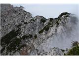 4
4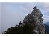 5
5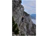 6
6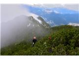 7
7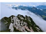 8
8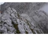 9
9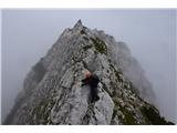 10
10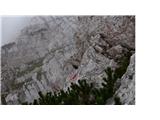 11
11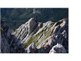 12
12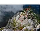 13
13 14
14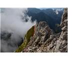 15
15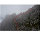 16
16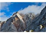 17
17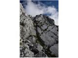 18
18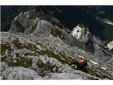 19
19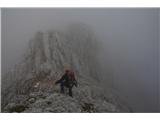 20
20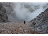 21
21