Potoče - Srednji vrh (via Sveti Jakob, below Potoška gora and over Baba)
Starting point: Potoče (520 m)
Starting point Lat/Lon: 46.3058°N 14.432°E 
Path name: via Sveti Jakob, below Potoška gora and over Baba
Time of walking: 4 h 45 min
Difficulty: easy unmarked way
Difficulty of skiing: no data
Altitude difference: 1333 m
Altitude difference (by path): 1485 m
Map: Karavanke - osrednji del 1:50.000
Access to starting point:
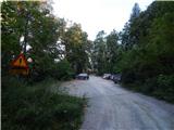
A) From highway Ljubljana - Jesenice we go to the exit Kranj - east, and then we continue driving in the direction of Jezersko. When we get to Preddvor we leave the main road and we continue driving left, and after few 10 meters, opposite the company Jelovica we continue right in the direction of village Potoče, St. Jakob and Potoška gora and lake Črnava. Further, the road leads through the settlement Hrib, above which we get to a crossroad, where we continue straight (left Hotel Bor and lake Črnava, right Senior citizens home Preddvor. Next follows a good 100 meters of a light ascent to the chapel, where the road turns right, and we are driving there past few more houses, and then before Senior citizens home we turn left on a larger macadam parking lot.
B) From highway Jesenice - Ljubljana we go to the exit Kranj - zahod and at the first crossroad, we continue left. Further, we drive through the underpass below the highway, and then we get to a roundabout, from where we continue driving in the direction of Golnik. The path ahead leads us through the settlement Mlaka pri Kranju, and at the end of the settlement, we continue right in the direction of the settlement Srakovlje. Next follows driving through Srakovlje, Spodnja Bela, Srednja Bela to Zgornja Bela, where we continue right towards Preddvor. At the end of the Preddvor, only few 10 meters before the road joins main road Zgornje Jezersko - Kranj, we continue left in the direction of village Potoče, St. Jakob and Potoška gora and lake Črnava. Further, the road leads through the settlement Hrib, above which we get to a crossroad, where we continue straight (left Hotel Bor and lake Črnava, right Senior citizens home Preddvor. Next follows a good 100 meters of a light ascent to the chapel, where the road turns right, and we are driving there past few more houses, and then before Senior citizens home we turn left on a larger macadam parking lot.
Path description:
Few strides before the beginning of the parking lot, by the fence of Senior citizens home Preddvor, we will notice hiking signposts, and we go on the path in the direction of Senčnica Josipine Turnograjske. The path starts by the already mentioned fence, and then continues through the forest. Through the forest, we are few minutes relatively steeply ascending, and then the path flattens and it brings us to Senčnica Josipine Turnograjske, where there is also an inscription box with an inscription book.
From the top follows a short descent on a forest path, and then we reach the forest road which we follow to the left, and there we are for a short time lightly descending. We soon reach the other wider road (road which leads from the parking lot near the Senior citizens home Preddvor and which bypasses Senčnica Josipine Turnograjske), which we cross slightly towards the left, where by the entrance into the forest, we notice red hiking signposts (to here possible also on the before mentioned road).
We continue in the direction of ruins of the castle Novi grad (Pusti grad) and footpath towards St. Jakob and Potoška gora. The path ahead is moderately ascending through a forested valley, and then splits into two parts.
We continue slightly right in the direction of St. Jakob, Potoška gora and Javorov vrh (left Novi grad (Pusti grad) and the path Juhantova pot) on the path which from a small valley gradually avoids more and more to the right. The marked path, which occasionally steeply ascends further few times crosses a forest road which leads towards St. Jakob, mountain hut Planinska koča pri Franciju and mountain hut Planinska koča Iskra na Jakobu. When higher, at the red color sign we again step on the road, there we continue left. Some 10 meters we walk on the road, and then we continue slightly right in the direction of the mountain hut Planinska koča Iskra na Jakobu (straight Planinska koča pri Franciju). Next follows few minutes of ascent and from the right joins the path "on the road". We continue left and the path out of the forest brings us to a marked crossing, where we continue on the left bottom path in the direction of St. Jakob (right Potoška gora, Javorov vrh...). Next follows only few minutes of a light ascent and the path at first brings us to the church of St. Jakob, and few steps ahead also to the mountain hut Planinska koča Iskra na Jakobu.
From the mountain hut and church we return to the last crossing, and from there we continue to the near road, on which we start descending, and after few steps, we get to the spot, where signs for source below Potoška gora (also Mežnarjeva voda) point us on a footpath which continues parallel with the road. The path at first leads us on a slightly exposed carved ledge, and then it passes into the forest, through which is lightly descending. The path soon stops descending, and then in a gentle ascent brings us to the source below Potoška gora.
Behind the source there is a marked crossing, where right downwards continues one of the marked paths, which lead towards Potoče, and we continue slightly left on an unmarked footpath which starts ascending diagonally. We soon get to the first cottage on Mihčeva kopišča, which we bypass on the right side. Only few minutes ahead we get to the second and the third cottage, at the latter (cottage Koča pri Pleškoti) is also appropriate space to rest.
Also third cottage we bypass on the right side, and then we continue on the path which passes into a lane of a forest. When we step out of the forest, the path splits, and we continue straight on at first a little poorly visible footpath (left Potoška gora). If we continue on the left path we will after few meters notice signs for Čemšenik and Baba, which point us right, but there isn't any nice passage, therefore we leave the mentioned path on the mentioned crossing few steps lower.
The path towards Čemšenik and Baba quickly passes into the forest and starts lightly descending. Next follows few minutes of descent, and then the path crosses a smaller torrent ditch (on part around the torrent is extensive site of wild garlic), after which it flattens or starts slightly ascending. Further, the path crosses a shorter clearing, after that when we again step out of the forest we get to partly grassy slopes of Baba, where at first we get to wooden holiday cottage, where we join the path from the mountain hut Dom na Čemšeniku. Here, behind the mountain hut we continue left and after few steps of ascent we get to the inscription box on Baba.
From the inscription box, we continue on an easy to follow footpath which continues on occasionally panoramic ridge, from which at first a nice view opens up towards Cjanovca, Kočna, Grintovec, Kalški greben and other surrounding hills. The path ahead at first continues on the left side of the ridge and after indistinct small saddle passes on the right (east) slopes of Potoška gora. Next follows few minutes of a diagonal ascent, and then we join the marked path which leads from Dom Čemšenik.
We continue upwards and relatively quickly we get to the saddle between Potoška gora on the left and secondary peak of Javorov vrh on the right.
On the saddle is marked crossing, where we continue right (left Potoška gora, slightly left mountain hut Planinska koča Iskra na Jakobu (on one of the mentioned paths we can descend) in the direction of Javorjev vrh. The path continues on a forested ridge, only to indistinct secondary peak it avoids to the right. A gentle ascent follows, from where again a view opens up a little and then the path returns into the forest and splits.
Here we continue left in the direction of Srednji vrh, Kališče and Storžič (straight Javorov vrh 15 minutes) on the path which after few additional strides, brings us to a pleasant well. Next follows half an hour crossing of the slopes below Javorov vrh, which ends on the saddle between the mentioned peak and Cjanovca.
We continue straight in the direction of Cjanovca and Srednji vrh (left Hudičev boršt, sharply right Javorov vrh) on the path which starts ascending steeper on and by east ridge of Cjanovca. Higher, the path brings us out of the forest on slopes covered with dwarf pines, and we continue on steeper and in parts very panoramic path. The path, from which beautiful views are opening up on Kočna, Grintovec, Kalški greben and Gorenjska, is slowly turning slightly towards the left. This more and more panoramic and relatively steep path, we then follow all the way to the top of Cjanovca, on which stands bench and smaller cairn.
From Cjanovca we continue towards the north on the path which through a lane of dwarf pines descends on a small saddle between Cjanvca and Srednji vrh. Here we step on the ridge, which we then follow to Srednji vrh, and we reach it after few minutes of additional walking.
Potoče - Sveti Jakob 1:15, Sveti Jakob - Mihčeva kopišča 30 minutes, Mihčeva kopišča - Baba 25 minutes, Baba - Cjanovca 2:20, Cjanovca - Srednji vrh 15 minutes.
Pictures:
 1
1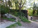 2
2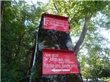 3
3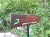 4
4 5
5 6
6 7
7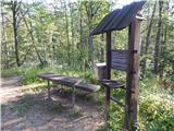 8
8 9
9 10
10 11
11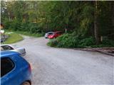 12
12 13
13 14
14 15
15 16
16 17
17 18
18 19
19 20
20 21
21 22
22 23
23 24
24 25
25 26
26 27
27 28
28 29
29 30
30 31
31 32
32 33
33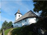 34
34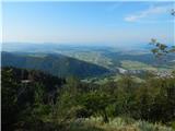 35
35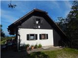 36
36 37
37 38
38 39
39 40
40 41
41 42
42 43
43 44
44 45
45 46
46 47
47 48
48 49
49 50
50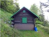 51
51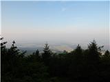 52
52 53
53 54
54 55
55 56
56 57
57 58
58 59
59 60
60 61
61 62
62 63
63 64
64 65
65 66
66 67
67 68
68 69
69 70
70 71
71 72
72 73
73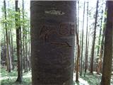 74
74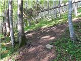 75
75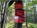 76
76 77
77 78
78 79
79 80
80 81
81 82
82 83
83 84
84 85
85 86
86 87
87 88
88 89
89 90
90 91
91 92
92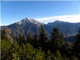 93
93 94
94 95
95 96
96 97
97 98
98 99
99 100
100 101
101 102
102 103
103 104
104 105
105 106
106 107
107 108
108 109
109