Pred Belo - Ojstrica (via Skok and Šraj pesek)
Starting point: Pred Belo (571 m)
Starting point Lat/Lon: 46.3188°N 14.6005°E 
Path name: via Skok and Šraj pesek
Time of walking: 6 h
Difficulty: very difficult unmarked way, difficult marked way
Difficulty of skiing: no data
Altitude difference: 1779 m
Altitude difference (by path): 1779 m
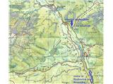
Map: Grintovci 1: 25.000
Access to starting point:
From Kamnik or Stahovica we drive to valley of Kamniška Bistrica, approx 2 km ahead from the parking lot by the bottom station of the cable car for Velika planina we drive to a bridge over the river Kamniška Bela and approx 100 meters ahead on the right side of the road in forest we drive on a smaller parking lot, where we notice signposts and the beginning of a marked path on Presedljaj, Konj and Korošica.
It is also possible to go before the bridge on the forest road and after about 100 meters park above the river, but this path is often muddy, and further you have to cross a river, which because of high water level sometimes isn't possible.
Path description:
From the parking lot, we continue at first on a marked footpath into the forest, and it soon joins a wide cart track and runs more or less along the riverbed of Kamniška Bela, which at first still has water, and further it is dry. After approx half an hour of comfortable walking, we get to a marked crossing, where we turn to the left, on an unmarked path towards the waterfall Slap Orglice and hunting footpath over Skok and Šraj pesek, and to the right or straight leads a marked path on Presedljaj, Konj and Korošica.
Further, the cart track slowly narrows into a comfortable footpath which runs right along the usually dry riverbed of Kamniška Bela and in good 10 minutes brings us towards the bottom pool of waterfall Slap Orglice. Before the waterfall, we turn right upwards, on a less beaten path which runs along another smaller dry riverbed of a torrent and after about 200 meters we cross it to the left and we turn into a steeper forest slope. Usually at this spot there are already cairns, because this is also the closest approach for many climbers below Vežica from Kamnik side.
At the beginning a quite steep and narrow footpath soon flattens and turns to the left and for some time runs parallel above the riverbed of a torrent, which also gives the water to the before mentioned waterfall. The footpath is further easy to follow, and it is slightly ascending and runs on grass and through a thin forest, a little on the right, a little on the left side of the riverbed and we stick to it all the way to the end, when we come to large rocks and to the gable of a small valley. There we cross a riverbed to the right and we go again on a steeper forest slope, which then in zig-zags in good 15 min brings us below Skok (jump), which has three smaller consecutive chimneys (climbing grade II to III). In the summer and during the drought, the rock is usually dry, and when it is wet at the climbing causes additional inconveniences, but with some experience and sense for climbing, you won't have any problems; for downwards it is recommended to use a rope (30 meters is enough) and abseil, because for this purpose on two key spots, there are two wedges.
When we climbed Skok (jump), above it we go left again on a well visible footpath which goes now even steeper upwards, at first among grass, and then through the last remains of the forest. On this part, on the path, there is also some thin gravel and because we walk in zig-zags, we have to be careful, not to trigger the stones to eventual followers at the ascent.
When we come out of the forest, in front of us and then on the right we notice mighty walls of Vršaki and Vežica and the scree of Šraj pesek. When we go up we walk more on the right and closer to the walls, at the end of the scree - opposite the bigger rocky cave, we ascend also over a rocky jump, and then also through a lane of dwarf pines. Soon after this a nice view opens up on Petkove njive below us and on the entire Ojstrica from the south side. Petkove njive is for this altitude a really huge, flat and green meadow, from the left the path descends there from Srebrno sedlo (and from the mountain hut Koča na Kamniškem sedlu), and on the right we can admire compact walls of Lučki Dedec. The path from Petkove njive towards the mountain hut Kocbekov dom na Korošici is otherwise short, but from this side not marked and if you gon on the shortest and the closest path, you can again get into high dwarf pines.
From a nicely settled mountain hut on Korošica on Ojstrica it is best to do a circular tour, up on the eastern (right) ridge and back on the western or southern to the mountain hut, and from the hut ahead it is all marked.
The described path from the valley upwards is appropriate also in the summer, because the larger part of morning there is shade below Vršaki and Vežica and a pleasant coldness, and you get a lot of sun on the descent in the afternoon, but the path downwards is still less strenuous.
The distance of walking: approx 4 hours to Korošica and another 1.5 to 2 hours to the top.
Pictures:
 1
1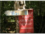 2
2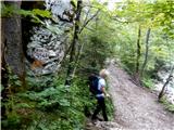 3
3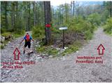 4
4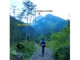 5
5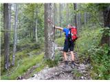 6
6 7
7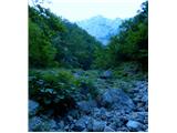 8
8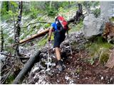 9
9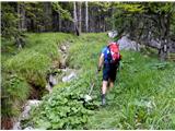 10
10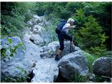 11
11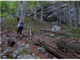 12
12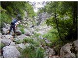 13
13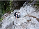 14
14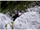 15
15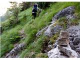 16
16 17
17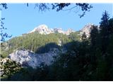 18
18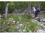 19
19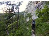 20
20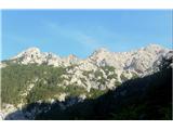 21
21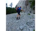 22
22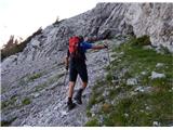 23
23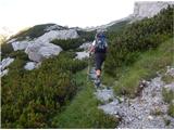 24
24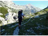 25
25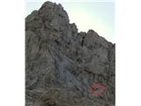 26
26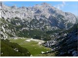 27
27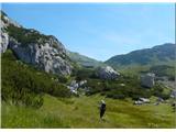 28
28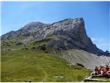 29
29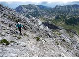 30
30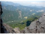 31
31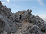 32
32 33
33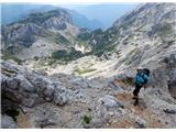 34
34 35
35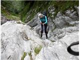 36
36 37
37