Alpl (Zisleranger Weg) - Roseggerhaus
Starting point: Alpl (Zisleranger Weg) (1081 m)
Starting point Lat/Lon: 47.50037°N 15.64534°E 
Time of walking: 3 h 15 min
Difficulty: easy marked way
Difficulty of skiing: no data
Altitude difference: 505 m
Altitude difference (by path): 625 m
Map:
Access to starting point:
Highway A2 Graz - Vienna we leave at the exit for Gleisdorf west, then follow the signs for Hartberg and Weiz, and later only Weiz. At the beginning of the town Weiz, we exit the roundabout in the direction of the settlement Birkfeld, then follow the road to the mentioned settlement and from there follow the signs for Alpl. On the mountain pass Alpl, we turn left in the direction of the inn Gasthof Schlagobersbauer and immediately turn left again onto a macadam parking lot, where we park.
From the border crossing Šentilj, we continue driving on the highway towards Graz and further towards Linz and Salzburg. We soon leave highway A9 and continue driving slightly right in the direction of Vienna, proceeding along the expressway S35. Near the settlement Bruck an der Mur, we reach highway S16 and follow it in the direction of Vienna. We leave the mentioned highway at the exit for Mitterdorf, and upon reaching the roundabout with the old road, we take the first exit in the direction of Vienna. After the settlement Krieglach, we turn right towards the settlements Birkfeld and Alpl. On the mountain pass Alpl, we turn right in the direction of the inn Gasthof Schlagobersbauer and then immediately left onto a macadam parking lot, where we park.
Path description:
From the parking lot, we return to the main road and carefully cross it, then continue on the macadam road, which turns right and a few minutes later left. When the road enters the forest, we choose the slightly left road, then in the forest, we turn right onto a footpath that continues along a strip of blueberries. This path leads us to a crossing, where we turn right toward Jägerhöhe and Hauereck.
A few more minutes of walking follow, and we reach the crossing at Jägerhöhe, from where we continue slightly left (to the right is the guesthouse Roseggerhof) and follow the signs for the cross Rotes Kreuz and the mountain hut Hauereck. A little further, we temporarily leave the forest, where the path leads us through high grass, which is often wet after rain or in the morning dew. When we re-enter the forest, a few minutes of easy walking follow, and we arrive at the cross Rotes Kreuz, where the next marked crossing is located.
We continue to follow the signs for Hauereck, and when we leave the forest, we descend to a rough road, which we follow to the right, continuing straight at a smaller crossroad. A little further, we temporarily leave the road, turning slightly right onto a footpath, and after a few minutes, we return to the road, which we follow all the way to the mountain hut Hauereck.
We bypass the cottage on the left side, from the crossing we go slightly right onto a cart track, along which there are signs for Pretulalpe and Stuhleck. The path ahead also crosses a grazing fence, then ascends more steeply to the area of wind turbines, where we step onto a macadam road. Also on the road we continue ascending, and from the path, a view opens up slightly toward the Northern Limestone Alps. When the road flattens on the left, just a short distance from the path, we notice the cottage Holta-Hütte, situated on the spacious mountain pasture Rattner Alm.
Mountain hut Holta-Hütte we bypass on the right side and continue walking on the macadam road, which then ascends through the grazing areas of mountain pasture Rattner Alm. A few minutes higher, we cross a grazing fence, then go slightly left from the crossroad. Higher up, the path leads us through a strip of sparse forest, and then we reach the wind power plant located near the summit of Steinriegel.
Here, we turn slightly right and ascend in a few steps to the cross on the panoramic summit.
From the cross, we return to the road and continue northeast, soon turning slightly left from the road onto a parallel mountain path that runs alongside the grazing fence separating the marked path from the road. Next follows a gentle descent along the fence, where the road and wind power plants end. A little lower, we enter a sparse forest, and the path gradually starts ascending again, following the marked path at a few smaller crossroads. Further on, the path ascends more steeply, and with beautiful views, we arrive at the mountain hut Roseggerhaus.
The starting point - Hauereckhütte 1:45, Hauereckhütte - Holta-Hütte 0:30, Holta-Hütte - Steinriegel 0:25, Steinriegel - Roseggerhaus 0:35.
The description and pictures refer to the condition in July 2024.
Pictures:
 1
1 2
2 3
3 4
4 5
5 6
6 7
7 8
8 9
9 10
10 11
11 12
12 13
13 14
14 15
15 16
16 17
17 18
18 19
19 20
20 21
21 22
22 23
23 24
24 25
25 26
26 27
27 28
28 29
29 30
30 31
31 32
32 33
33 34
34 35
35 36
36 37
37 38
38 39
39 40
40 41
41 42
42 43
43 44
44 45
45 46
46 47
47 48
48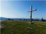 49
49 50
50 51
51 52
52 53
53 54
54 55
55 56
56 57
57 58
58 59
59 60
60 61
61 62
62