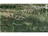
Breginj - Brezje / Montemaggiore (via Plazovi)
Starting point: Breginj (550 m)
Starting point Lat/Lon: 46.262°N 13.4259°E 
Path name: via Plazovi
Time of walking: 3 h
Difficulty: easy marked way
Difficulty of skiing: no data
Altitude difference: 269 m
Altitude difference (by path): 269 m
Map: Julijske Alpe - zahodni del 1:50.000
Access to starting point:
First, we drive to the center of Kobarid, and then we continue driving towards the border crossing Robič. Near the village Staro selo, we leave the main road which runs towards the border crossing Robič and we continue driving right in the direction of Breginj. Further, we follow a mainly ascending road to Breginj, where we park on a parking lot near the church.
Path description:
Breginj – Plazi – Brezje Easy mountain path. Easier variant on tradicionalnem hike from Breginj to Brezje, which takes place every last weekend in September.
Time of walking: 3 hours Difficulty: Easy marked path By the path: stream Bela with characteristic barriers »špere«, renovated sawmill Patrinova žaga, source of drinking water Čadonov studenček, monument of the fallen in 2nd world war in Plazi, strems Beli and Črni potok (later join in river Nadiža) Description of the path: From the parking lot in Breginj we continue on the asphalt road to the right in the direction of Stol and Muzec. The road at first ascends through the village, at the crossroads we follow it in an already known direction. Higher, the road loses an asphalt covering and past old renovated sawmill (Patrinova žaga) brings us to a marked crossroad, where we continue slightly right (left church of Marija Snežna). The road which continues to moderately ascend, soon brings us to a marked crossing, where a marked footpath on Muzec (Musc) branches off to the left. We go on the mentioned path, which is further moderately ascending through the forest. Further, the path brings us to a smaller well (source with a drinking water - Čadonov studenček), and then turns a little to the left and starts ascending steeper. Higher, the path flattens and it brings us to a smaller crossing, where we continue straight (left path for Musc). In Plazi, which are very interesting area with many streams, waterfalls, sources and scree after which this area probably got its name, we can stop by the monument from 2nd world war. Here we continue on the forest road which is also circular cycling path. Then we go through the forest, we come to a crossing for Nizki vrh, we continue straight, we cross the national border which leads here and we soon cross at first Črni, and then also Beli potok. It is wonderful to stop by stream Beli potok (we immediately see from where its name), where little higher we view smaller waterfall and we go ahead on a forest path, which soon brings us to the village Brezje on the Italian side, where we can view after earthquake in the year 1976 renovated village. We need to organize transport back in Breginj or we return on foot.
Pictures:
 1
1