Čadrg - Grušnica (via planina na Kalu)
Starting point: Čadrg (740 m)
Starting point Lat/Lon: 46.22748°N 13.73618°E 
Path name: via planina na Kalu
Time of walking: 2 h 30 min
Difficulty: partly demanding marked way, easy unmarked way
Difficulty of skiing: no data
Altitude difference: 830 m
Altitude difference (by path): 870 m
Map: TNP 1:50.000
Access to starting point:
We drive to Tolmin, then at the traffic light crossroad we continue towards Zatolmin. When we get to Zatolmin we follow the signs for Čadrg and Tolminska korita. At the parking lot near the entrance to Tolminska korita, we continue on the asphalt road. The road further becomes very narrow, making passing difficult. The narrow and occasionally steep road leads us to the mountain village Čadrg. We continue through the village towards the ecological farm Pri Križarju. A little before the mentioned farm, there is a marked smaller parking lot by the road where we park.
Path description:
From the parking lot, we continue on the road past the farm, behind which we reach a crossing. To the left, slightly downwards, leads the cart track towards the vantage point Žlejžn, and we continue on the right road towards Planina Kal and Planina Razor. The road soon ends, and we continue right on an ascending cart track. The cart track then leads us to a clearing where there is another marked crossing.
Straight ahead leads the path towards Planina Prodi and the source of Tolminka, and we go right towards Planina Kal. After a short ascent, the cart track transitions into a footpath, and the path leads us into the forest. Next follows an ascent through the forest, and just before the forestry cableway, a signpost directs us left onto a narrower footpath.
The path continues through the forest, ascending relatively steeply, mostly in long zig-zags. Higher up, the path passes a bench where the view opens slightly towards the village Čadrg and the surrounding peaks.
We still continue on the path which is marked with red arrows and with Knafelc blazes. The path then leads us to a forested saddle by mountain pasture Rešljeva planina, where there is another bench.
At the saddle, we follow the path along a wire fence, initially descending slightly. We then cross steep slopes towards the northeast, mostly in a gentle ascent for quite some time. Occasionally, the slope is quite steep, requiring caution in some spots. Later, the path brings us near some torrent streams, where we notice water storages and a well with drinking water along the path.
We then ascend slightly through the forest, and the path leads us to signposts by a grassy slope below the summit Javor. We continue slightly to the right and follow the path along the left edge of a meadow, which leads us back into the forest. A wider path soon brings us to a marked crossing where we join the marked path from Tolminske Ravne.
From here, we continue on a wide, marked path through the forest, which in about 20 minutes leads us to the mountain pasture Planina na Kalu, where there are some cottages.
From the saddle, from where a nice view opens up towards the valley of Tolminka, Vrh nad Peski, and a view is also nice on peaks above Tolminske Ravne, which we occasionally already saw during the ascent, we continue slightly left from the ridge of Grušnica, on easy to follow path. After a shorter diagonal ascent we reach the eastern ridge of Grušnica, from where a nice view opens up towards the south. Here the path turns a little to the right, and then in few minutes of more and more panoramic walking it brings us on a panoramic peak, from which a nice view opens up on surrounding mountains.
Čadrg - Planina na Kalu 2:15, Planina na Kalu - Grušnica 0:15.
Pictures:
 1
1 2
2 3
3 4
4 5
5 6
6 7
7 8
8 9
9 10
10 11
11 12
12 13
13 14
14 15
15 16
16 17
17 18
18 19
19 20
20 21
21 22
22 23
23 24
24 25
25 26
26 27
27 28
28 29
29 30
30 31
31 32
32 33
33 34
34 35
35 36
36 37
37 38
38 39
39 40
40 41
41 42
42 43
43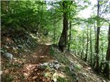 44
44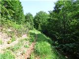 45
45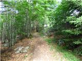 46
46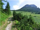 47
47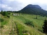 48
48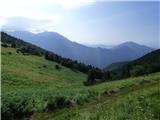 49
49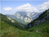 50
50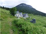 51
51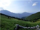 52
52 53
53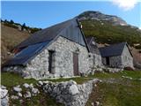 54
54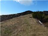 55
55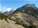 56
56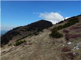 57
57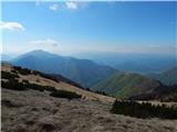 58
58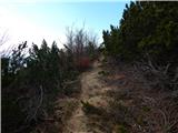 59
59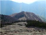 60
60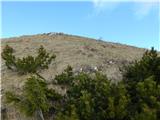 61
61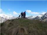 62
62 63
63