Starting point: Cerknica (580 m)
| Latitude/Longitude: | 45,79290°N 14,36730°E |
| |
Walking time: 1 h 40 min
Difficulty: easy marked way
Elevation gain: 534 m
Elevation difference along the route: 534 m
Map: Snežnik 1:50.000
Recommended equipment (summer):
Recommended equipment (winter):
Views: 190.176
 | 9 people like this post |
Access to starting point:
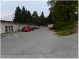
From the Ljubljana - Koper highway, take the Unec exit and follow the road ahead in the direction of Cerknica. Just a few 100 m before Cerknica, we will arrive at a crossroads, where the road towards Begunje and Slivnica branches off to the left. Here we continue straight (not in the direction of Slivnica) on the road, which soon brings us to the center of the settlement. When we have driven across the bridge over the river Cerkniščica, pay attention, because a little further on, the road that brings us to our starting point branches off to the left. Approximately 50 m after the discount store Hura, on the left side of the road we will notice the mountain signposts for the mountain hut Dom na Slivnici, which direct us left onto an ascending road. After a short ascent, we will notice the beginning of the footpath, and on the opposite side of it we park on the asphalted parking lot.
Route description:
From the parking lot we first cross the road, then head onto the footpath in the direction of the mountain hut Dom na Slivnici. The path first gently ascends through a strip of bushes, then transitions into a pine forest, where it begins to ascend somewhat more steeply. Higher up, we cross a few forest roads, after which the path becomes almost completely level. There follows a few minutes' walk through mixed forest, then it joins a poorer forest road, which we follow for only a few 10 m. Further on, the blazes direct us slightly to the right into a strip of bushes, and the path then takes us over a pasture fence onto the vast grassy slopes of Slivnica. Along the gentle path, which leads us further across these grassy slopes, beautiful views open up onto the Javorniki ridge and Cerkniško polje with Cerkniško jezero lake. Further on, the path enters a strip of sparse pine forest and begins to ascend moderately. When we step out of the forest again, we already see the Dom na Slivnici mountain hut ahead of us, which is just 5 minutes of easy walking away.
We bypass the mountain hut on the right side, and the blazes direct us into the forest onto a moderately steep footpath that continues ascending via gentle steps. The mentioned path ends at the turning area (parking lot) of the forest road to Slivnica. From the turning area, we continue along a partly overgrown path that climbs through a strip of raspberry bushes, then transitions onto a grassy slope, across which we ascend to the summit of the 1114 m high Slivnica in a few 10 steps of further walking.

Photos:
 1
1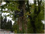 2
2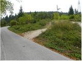 3
3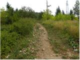 4
4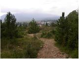 5
5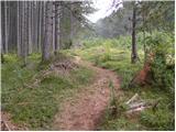 6
6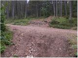 7
7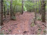 8
8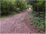 9
9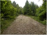 10
10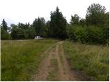 11
11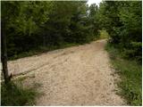 12
12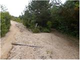 13
13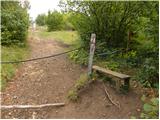 14
14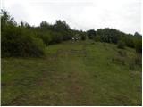 15
15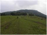 16
16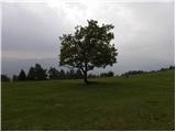 17
17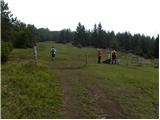 18
18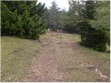 19
19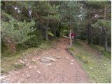 20
20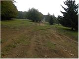 21
21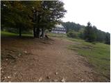 22
22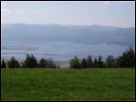 23
23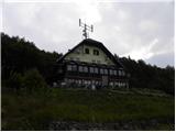 24
24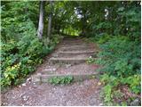 25
25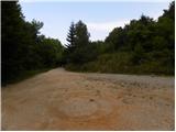 26
26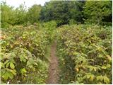 27
27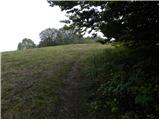 28
28 29
29
Discussion about the trip Cerknica - Slivnica
Show older messages
|
| Damijan13. 05. 2007 |
Easy morning or afternoon tour.
|
|
|
|
| zgonikov29. 09. 2007 |
Nice trip, but a bit longer and nice views on clear days.     
|
|
|
|
| cjetko24. 02. 2008 |
With family, I was at Slivnica: nice easy tour and even nicer view over Lake Cerknica, time 1:15 h
|
|
|
|
| iztok17. 01. 2009 |
A nice day for Slivnica (with skis or without)
|
|
|
|
| prlekj18. 05. 2009 |
The trail is really beautiful, but a problem arises when you arrive up there and the hut is closed (during working hours)! If I were from Cerknica I wouldn't worry, I'd come another time!

|
|
|
|
| Pohodnik1112. 09. 2009 |
Very nice path and very nice view. A bit disappointed with the path description and attached photos, because I think the view is very nice. You can see the entire Lake Cerknica, Javorniki, Nanos, Snežnik, and in fine weather also Triglav.
|
|
|
|
| JanaG21. 09. 2009 |
With two kids, I was at Slivnica mid-August, on a "working" day, and the hut was closed
there was no stamp at the top of Slivnica either....but we came from Koper for the raspberries
|
|
|
|
| katjuša221. 09. 2009 |
The Dom na Slivnici is apparently for sale, due to the caretaker's retirement, that's why it's most likely closed.
And since there are no interested buyers despite the low price, it will probably keep its doors closed.
|
|
|
|
| sk221. 09. 2009 |
"there was no stamp at the top of Slivnica either"
The stamp at the top is on the box (holder) covered with an iron cap. Installed new in June 2008
LP
|
|
|
|
| bostjanm23. 09. 2009 |
On Sunday, 20.9., the hut was open, tea and pancakes yum yum.
|
|
|
|
| pohodnica8825. 10. 2009 |
Where is the stamp now up there (in the hut or in front of the hut - in case it's accidentally closed)?
|
|
|
|
| snežinka30. 10. 2009 |
We also climbed to Slivnica (28.10.09). The hut at the top was closed. We got the stamp in front of the hut in the box with the logbook and likewise at the top of Slivnica also a stamp, although the ink was dry - we moistened it a bit . The path is really undemanding, but varied and extremely interesting. The view is beautiful over the entire Cerkniško polje and beyond. We also encountered paragliders and saw the Coprniška jama cave. Really great trip.
|
|
|
|
| noteko17. 11. 2009 |
This data about the path time is quite exaggerated..... with normal walking it's less than an hour, to run there even well under 30min.
Otherwise, there's talk of a new hut owner...
|
|
|
|
| jlogar18. 11. 2009 |
Normal hiking takes 45 minutes, plus a bit more enjoyment with the views.
|
|
|
|
| Micky1. 05. 2010 |
Today was almost our traditional hike to Slivnica and to Lovska koča. The day was beautiful, sunny. Unfortunately, on this day still too many people drive to the hut by car.
Anyway, it was nice.
|
|
|
|
| Biser gora17. 12. 2010 |
Is the parking lot shown at the top of the picture plowed, and if not, is there any parking option?
|
|
|
|
| omny17. 12. 2010 |
Of course it's always plowed and trodden to the top.
|
|
|
|
| Micky17. 12. 2010 |
I suggest going on foot instead. It's a beautiful little tour for winter time. As long as there are no other obstacles for walking.
|
|
|
|
| bijan2. 04. 2011 |
With family we were on a trip to Slivnica. The nice path ended with extremely unfriendly service in the mountain hut. The waiter (I fear even the owner) insulted us harshly, despite the presence of a five-year-old child, because we ordered food at the counter. Since the unfriendliness didn't stop, we left the hut before eating lunch. I strongly advise all hikers against visiting the hut.
|
|
|
|
| srčica10. 04. 2011 |
Beautiful tour... finally the hut always open.. food excellent...
|
|
|
|
| darh23. 07. 2011 |
Mid-June we ascended to Slivnica via this trail. We were rewarded with wonderful views. More here.
|
|
|
|
| Kokta25. 09. 2011 |
Nice sunny day on Slivnica...definitely recommend a visit. Easy hike...suitable for everyone.
|
|
|
|
| marjeta0072. 10. 2011 |
Nice morning family outing. However, a bit strenuous for our 4-year-old. We stopped several times and even had to carry him, because he simply couldn't make it up the hill. Down was no problem, he was fast as a rocket
The view from the top is really wonderful.
|
|
|
|
| ulmusglabra21. 12. 2011 |
To me a very nice hike 
it's always trampled and plowed, sometimes I wish there were fewer people, but Notranjci apparently love going up there!
But anyway, up top fresh milk tastes great!
|
|
|
|
| Ajda_Zitnik26. 12. 2011 |
On 18.12.2011 I visited Slivnica, and I was a bit scared because there were criticisms about the staff in the hut. I have to admit that the staff was correct. The trip itself is nice, as for the walking time, it's such that you can walk up longer if people don't have stamina and I think it's quite right.
|
|
|
|
| Micky26. 12. 2011 |
Everyone walks at their own pace. I go up there 2x a week and it takes me about 50 minutes. Some take less, some more. It doesn't matter at all. As for the staff that's up there now, I think the remarks are unnecessary.
|
|
|
|
| wolphgang27. 12. 2011 |
Obviously some of you don't understand that there is some average walking speed. Guidebooks (books, not people) usually stick to it. Unfortunately I notice on this website a lot of mountaineering and consequently lower times. Be aware that not all visitors to this site are such athletes as some of you.
|
|
|
|
| marjana2. 02. 2012 |
On Sunday we were on Slivnica from Cerknica. The moderate walking time of 1.5 hours is realistic, even though we walked 15 min less, despite snowing nicely the whole way. From Slivnica we continued to Pokojišče. In the description of the Notranjska mountain path, the walking time is listed as 3 hours, which seems unrealistic to me for moderate walking. We walked 4:45 hours, spending about half an hour on a snack in between.
|
|
|
|
| Kokta14. 02. 2012 |
Snowy all the way, magical... those who don't hike in the mountains in winter don't know what you're missing . Very few people in the hut. Praise to the host for the super Slivnica stew and strudel. At the top -16 C and some wind, but worth every step. Recommend visiting Slivnica in winter. Dress nicely and hit the trail
|
|
|
|
| gorski svizec29. 02. 2012 |
Can someone tell me which days of the week the hut on Slivnica is open at this time. I plan to go up on Friday, March 9.
Best regards to all, especially Klavdy6
|
|
|
|
| rs561. 03. 2012 |
Just got back from Slivnica. I deliberately detoured to the hut to see what the hut's operating hours are. The hut is open Thursday, Friday from 10.00 to 20.00, Saturday and Sunday from 7.00 to 22.00
lp
|
|
|
|
| mgrego2229. 05. 2012 |
We've been to Slivnica with my husband many times, especially beautiful in spring when wild garlic grows and everything smells of garlic. Then I recommend part of the path via the shortcut, on the narrow path, with green wild garlic on both sides pushing even onto the narrow path. Otherwise, this trip is wonderful in all seasons, with special charm in winter. Something else positive about this trip. Along the path, be attentive or look high in the trees, not just underfoot. Some trees are even marked with faded white-red ribbons. Look up and you'll see wonderful bird nest boxes. My husband and I counted 28 of them. Once we accidentally met the man who made them and he told us there are over 50 in total. Later, my husband made 8 nest boxes, which our daughter beautifully painted with lovely motifs and markings. So be attentive along the path. Regarding the staff, full praise to the young waiter with long hair. He always finds a kind word and if there's no big crowd, he'll quickly say something nice. Otherwise, it's understandable that there's not always time. Food is fine, service OK, just as it should be. Keep it up.
|
|
|
|
| Nikica16. 08. 2012 |
My husband and I went to Slivnica on 15.8. The path is great, suitable also for those without much fitness (you just need a bit more time ). The whole time it smelled like the sea, on the plateau a bit higher there were horses and cows grazing. The path winds a bit through the forest, a bit through the clearing, the views are phenomenal. You really need 1.5 hours (normal to fast walking). But you have to watch the markers, namely my husband and I got off the hiking path and walked the last couple hundred meters on the gravel road meant for vehicles. There are also many loose stones on the path, so especially downhill, proceed carefully (hiking shoes and poles recommended).
The hut was open and service excellent (we didn't order food as we had everything with us). The view is worth the hike!!
They had goulash, fish, strudel, pancakes....something for everyone. It's worth checking in advance when the hut is open so you don't arrive disappointed. Next time we'll climb the hill by bike. On the way, we also saw Cerkniško jezero, Rakov Škocjan (2.5 km wide/long valley where you enjoy on foot or by bike) then went to Lipica (guided tour of the stud farm for 11€ adults) and ended the trip.
|
|
|
|
| Darxta20. 09. 2012 |
What's the water level in Lake Cerknica? This weekend we'd go to Slivnica and it'd be "oh so great" if we had a lake view too, not just fields
Hope someone passes by daily and reports, thanks in advance!
|
|
|
|
| martinza20. 09. 2012 |
The water is already quite high, so you'll have lake view too
|
|
|
|
| Darxta20. 09. 2012 |
Great, THANKS!!!
|
|
|
|
| brauni6. 01. 2013 |
The path is really fun, varied, for about an hour's walk. At the top a wonderful view of the lake awaits. Better to set out on the path with your own snack in your backpack. Organization in the refreshment hut is somewhat weak. On Sunday food ran out by 14h already. Even to the cash register it was hard to get, because there weren't enough clean cups.
|
|
|
|
| amarilis6. 01. 2013 |
Our group too was satisfied with the walked path,which wasn't too demanding.But we were more grumpy because of the lack of tea.Luckily there was some in the teapots,otherwise our dry throats would have "glued" the tongue in dry mouths.But in the future,when it will be hiked more intensively in those areas-things will improve significantly.Hope dies last!LP
|
|
|
|
| urskagucek13. 01. 2013 |
Super! Wonderful Saturday, in the hut very, very friendly, tea very good.
|
|
|
|
| mgrego2226. 01. 2013 |
News for all hikers. Every month at full moon there is an organized night hike to Slivnica. Then the hut is open and the atmosphere is very pleasant. Praise to the organizers and friendly staff. After refreshments there was also a lecture on the topic "Cerknica of old" with slide projection. Praise to Mr. Miru for the pleasant presentation.
|
|
|
|
| Lunca20. 02. 2015 |
Is the hut open this weekend?
|
|
|
|
| lumi28. 04. 2015 |
Is the hut open during the week - at least for a beer!?
|
|
|
|
| rezist28. 04. 2015 |
No. No beer until the weekend!
|
|
|
|
| Hribolazec8120. 09. 2015 |
Where can I see if anyone knows how the hut is open now in September?
Because we're coming from Styria
Thanks
|
|
|
|
| Hribolazec8120. 09. 2015 |
I found the opening hours of the hut on one website, if anyone else needs it I'll post it here:
From 15 September to 15 May it is open from Friday to Sunday and on holidays, from 16 May to 14 September from Wednesday to Sunday
|
|
|
|
| J.P.21. 02. 2021 |
Beautiful tour, quite crowded but there's enough space :-) If you want to see the entire Cerknica Lake from above, this is the best spot. Regards
|
|
|
|
| bizgo9328. 02. 2021 |
Exceptionally nice hike. Today I visited Slivnica after a few months in beautiful weather (there were quite a few people but that's normal on a sunny Sunday). The first third of the path through the forest is quite steep, then it levels out (across beautiful pastures from where there is also a nice view of the Cerknica plain, Javorniki, Snežnik, Nanos, all 3 of our mountain ranges...). A little below the hut the path steepens again to the top. Nice views from the hut and on the pasture just below the summit (above Martinjak). From the summit itself the view is somewhat limited due to the forest. Overall a very nice trip with beautiful views and also walks across expansive pastures below the summit.
|
|
|
|
| Tajka6719. 03. 2023 10:21:22 |
Yesterday after a long time I chose this trail. Just a note: the SPP stamp is not in the hut, mischief-makers took it around New Year. But it is at the top by the transmitter.
|
|
|
To post a comment you must log in:
If you do not yet have a username, you must first
register.