Starting point: Činžat (426 m)
| Latitude/Longitude: | 46,54164°N 15,43268°E |
| |
Walking time: 1 h
Difficulty: easy unmarked way
Elevation gain: 279 m
Elevation difference along the route: 290 m
Map: Pohorje 1:50.000
Recommended equipment (summer):
Recommended equipment (winter): ice axe, crampons
Views: 235
 | 1 person like this post |
Access to starting point:
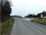
A) From the road Maribor - Dravograd, between HE Fala and HE Ožbalt we turn left towards Lovrenc na Pohorju (from the direction of Dravograd we turn right). On the other side of Drava we start ascending along Radoljna, and at the marked crossroad, we go left towards Činžat and Ruše. A short ascent follows, and on the saddle where we notice red hiking signposts, the described path begins. At the crossroad, there aren't any arranged parking spots, so we park a little away in an appropriate place.
B) We drive into Ruše, and then we follow the road towards Lovrenc na Pohorju. In the settlement Činžat we arrive at the saddle where we notice red hiking signposts, where the described path begins. At the crossroad, there aren't any arranged parking spots, so we park a little away in an appropriate place.
Route description:
From the starting point, we go on the road following the signs for sawmill Pušnik and the forest learning trail Ruta. From the timber warehouse, the road enters the forest; as we briefly walk along the forest edge, two lesser roads branch off to the right toward two homesteads, but we continue straight to a small saddle where a crossroad is located.
We continue straight in the direction of sawmill Pušnik (left downward to Puščava, right downward to Fala Grad) and continue for a short time through the forest.
When we leave the forest, we continue straight, then pass the farm Korman Pucer. Next follows the crossing of a high-voltage power line route and an ascent to the homestead Matec (marked as Murko on maps), where the forest learning trail Ruta begins.
A little further from the homestead, signs of the learning trail direct us slightly right onto a poorer macadam road, which begins to ascend more steeply. Higher up, we reach a smaller crossroad, where a silhouette of a chamois directs us sharply left, passing benches and information boards of the learning trail. Further on, the road becomes increasingly worse and gradually turns into a more and more scenic cart track. When we reach the ridge a little higher, we leave the forest learning trail Ruta and continue sharply left onto an unmarked path, which ascends diagonally along the western side of the ridge. A little further at a small crossing, we go left, then quickly reach Lobnikov vrh, where a salt lick is located.
For a beautiful view, we return to the spot where we left the learning trail and continue along the scenic ridge, or slightly to the right of it, to a marked vantage point, from which views open up towards the river Drava and the surrounding hills when looking to the left and right.
The description and pictures refer to the condition in March 2024.

Along the route: Ruta (517m)
Photos:
 1
1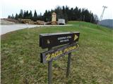 2
2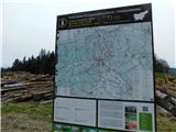 3
3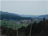 4
4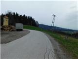 5
5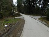 6
6 7
7 8
8 9
9 10
10 11
11 12
12 13
13 14
14 15
15 16
16 17
17 18
18 19
19 20
20 21
21 22
22 23
23 24
24 25
25 26
26 27
27 28
28 29
29 30
30 31
31 32
32
Discussion about the trip Činžat - Lobnikov vrh
To post a comment you must log in:
If you do not yet have a username, you must first
register.