Dol pri Hrastniku - Mrzlica
Starting point: Dol pri Hrastniku (313 m)
Starting point Lat/Lon: 46.14112°N 15.11592°E 
Time of walking: 2 h 50 min
Difficulty: easy marked way
Difficulty of skiing: no data
Altitude difference: 809 m
Altitude difference (by path): 910 m
Map:
Access to starting point:
From the road Hrastnik - Rimske Toplice we drive to the center of the settlement Dol pri Hrastniku, where by the parish church of St. Jakob and the NOB monument the described path begins. We park at one of the parking lots in the center of the settlement, or we can also park at a slightly larger parking lot by the cemetery, which is less than five minutes from the start of the described path.
Path description:
From the starting point, we head north, following signs for Kal (a path south leads to Gore), and bypass the church on the right side. We initially walk on a sidewalk along the road Trg borcev NOB, and later along Partizanska cesta. At the company Spectra 9 d.o.o., the sidewalk ends, and shortly after, we reach the path Srečno. We generally do not follow the signs for this path, as our route and the path Srečno coincide only briefly.
A little further, at the memorial of Slovenia’s independence, we turn right onto a side road, then follow Knafelc blazes (the path Srečno veers slightly more to the right here), ascending past individual houses. After the last house, we transition to a steep cart track that leads into the forest. In the forest, we turn right from the cart track onto a footpath that ascends quite steeply, and higher up, slightly bypasses a nearby homestead to the right. Upon leaving the forest, we cross an asphalt road leading toward the settlement Krištandol (turning left downhill allows a return to the starting point), then diagonally ascend a grassy slope, from which a first view opens toward Kum, the highest peak of Posavsko hribovje. When we re-enter the forest, we gradually move onto steeper slopes, ascending diagonally, requiring extra caution, especially in wet conditions. The steepness of the slope soon eases, but the path remains quite steep. Higher up, we reach a road leading toward the cottage Planinski dom na Kalu, the ski slope Rajska dolina, and some hamlets (here, too, turning left downhill allows a return to the starting point or to Hrastnik).
The path continues along an asphalt road, mostly ascending moderately. At the second left turn, a marked path from the settlement Marno joins from the right, passing through Krištandol (with signs for Gore and Kopitnik).
A little further, the road flattens and leads to a junction at a small saddle, where an NOB monument is located.
Here, we continue straight toward Kal and Mrzlica (left to Hrastnik via Blate, right to Ostri vrh, Baba, and Zavrate), descending lightly on the asphalt road at first, then ascending again after a chapel. At a nearby house, there is an inscription box for the NOB path. We continue along the road, which first turns right, then follows a long, scenic left turn. We proceed along the marked road, which has several crossroads, and after a stretch of forest, we arrive at the ski slope Rajska dolina. We cross the ski slope (passage is forbidden and dangerous during its operation, as is passing through the tunnel). After the next NOB memorial, we reach a marked junction where paths via Klobuk and Ravne, both starting in Hrastnik, join from the left.
We continue straight, then the signs lead us right onto grassy slopes, where we steeply ascend straight uphill. Here, beautiful views open up in all directions, particularly striking is the view back toward Kum. The path soon flattens and begins a gentle descent on Kalska planina. A little further, we return to the road and continue to the nearby cottage Planinski dom na Kalu.
We bypass the cottage Planinski dom na Kalu on the left (to the right, before the cottage, are Šmohor, Malič, Gozdnik...), then turn right into the forest on a path toward Mrzlica. The path ahead leads gently through the forest, quickly bringing us to a small junction. We choose the slightly left path, marked by an inscription on a tree for the peak (the right path bypasses the summit of Kalski hrib and is about a minute shorter if continuing toward Mrzlica). Next follows a gentle ascent, and below the summit of Kalski hrib, the path becomes slightly steeper, quickly leading us to the inscription box on Kalski hrib.
From Kalski hrib, we continue northward and begin descending through the forest, soon joining the previously mentioned path that bypasses Kalski vrh. Next follows a moderate descent, where along the path in springtime we notice wild garlic, and then we reach the saddle between Kalski hrib and Mrzlica, where there is also a marked crossroads.
We continue toward Mrzlica, bypassing the kužni stone on the right side. Next follows an ascent over a grassy slope, then we return to the forest, through which we ascend quite steeply. Higher up, the path flattens and leads us to the edge of the forest, where it splits.
We continue slightly to the right, back into the forest (straight ahead leads a shortcut directly to the summit of Mrzlica) and then ascend gently to moderately in a diagonal ascent toward the right. When we leave the forest, only a short walk remains to the mountain hut Planinski dom na Mrzlici, and here we turn left and ascend to the panoramic summit of Mrzlica in less than five minutes of further walking.
Dol pri Hrastniku - Mali Kal 1:10, Mali Kal - Planinski dom na Kalu 0:50, Planinski dom na Kalu - Kalski hrib 0:10, Kalski hrib - Mrzlica 0:40.
The description and pictures refer to the condition in March 2025.
Pictures:
 1
1 2
2 3
3 4
4 5
5 6
6 7
7 8
8 9
9 10
10 11
11 12
12 13
13 14
14 15
15 16
16 17
17 18
18 19
19 20
20 21
21 22
22 23
23 24
24 25
25 26
26 27
27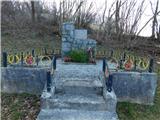 28
28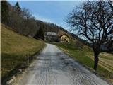 29
29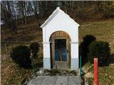 30
30 31
31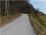 32
32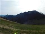 33
33 34
34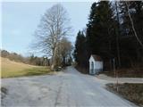 35
35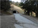 36
36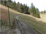 37
37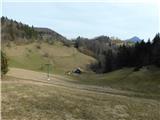 38
38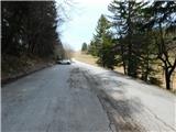 39
39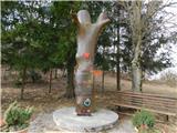 40
40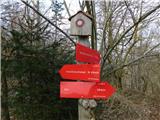 41
41 42
42 43
43 44
44 45
45 46
46 47
47 48
48 49
49 50
50 51
51 52
52 53
53 54
54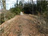 55
55 56
56 57
57 58
58 59
59 60
60 61
61 62
62 63
63 64
64 65
65 66
66 67
67 68
68 69
69 70
70 71
71 72
72 73
73 74
74 75
75 76
76 77
77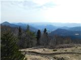 78
78