End of road on Pokljuka - Vernar
Starting point: End of road on Pokljuka (1340 m)
Starting point Lat/Lon: 46.3386°N 13.9045°E 
Time of walking: 4 h 15 min
Difficulty: very difficult pathless terrain
Difficulty of skiing: no data
Altitude difference: 885 m
Altitude difference (by path): 1000 m
Map: Triglav 1:25.000
Access to starting point:
From highway Ljubljana - Jesenice we go to the exit Lesce and follow the road ahead towards Bled. In Bled at the traffic lights, the signs for Pokljuka point us to the right. Ahead we drive through Gorje and past the abandoned ski slope Zatrnik to Rudno polje on Pokljuka (large parking lot, barracks and shooting range). From here we continue straight on a macadam road which a little further brings us to a crossroad, where we continue right (left Uskovnica). We follow this road to a parking lot at the end of the road (near are signposts for a mountain pasture Konjščica).
Path description:
From the parking lot at the end of the road, we continue on a wide and at first ascending cart track in the direction of the mountain pasture Konjščica. Cart track, which goes immediately into a dense forest, quickly flattens and after few minutes of easy walking turns into a footpath which continues by the left bank of the stream Ribnica. When the path gets very close to the mentioned stream it turns slightly to the right and it ascends steeper. Higher, the path flattens and out of the forest brings us on the bottom edge of ample Konjščica. Here the path turns slightly to the left, crosses a stream and after few additional strides, it brings us to cheese cottage on the mountain pasture Konjščica.
From the cheese cottage, we continue on a pleasant path, which in few minutes of a light ascent brings us on the upper edge of the mountain pasture. Here the path goes in a lane of dwarf pines and bushes and gradually starts ascending steeper. In the upper part of the ascent towards Jezerca the path from Rudno polje joins from the right, and we continue straight on a moderately steep path, which in few minutes of additional walking brings us to Jezerca, where the path flattens and turns to the left.
Next follows easy walk to the signpost, which marks the main area of TNP, and then the path starts moderately ascending by the torrent (at first a well). The path higher passes on the right side of the torrent (looking from the direction of ascent) and then it ascends diagonally to a saddle Studorski preval.
From the saddle, from where a nice view opens up to Bohinj side, we continue straight (left Ablanca, right Veliki Draški vrh and sharply right saddle Srenjski preval) on the path which starts descending and after few steps of descent turns to the right. A short descent follows, and then the path continues in crossing, at first slopes below Veliki Draški vrh and later Tosc. When we come on unvegetated southern slopes of Tosc we will get to a smaller crossing, where the unmarked path on Tosc branches off to the right (turn-off is marked). Only few steps ahead, from the left almost unnoticeably joins the path from Uskovnica.
We continue straight on a panoramic path which starts turning more and more to the right, and in doing so passes on increasingly steep slopes of Tosc. Ahead we get to artificially carved rocky ledge, over which leads wide and to falling stones exposed path (caution - active rockfall!). The mentioned ledge we walk in a gentle descent, and then the path turns to the left and for a short time ascends on a little narrower path. Further, the path flattens and passes on less steep slopes. Only a little further, we come at the marked crossing, where from the left joins the path from the valley Voje. We continue straight in the direction of Vodnikov dom (slightly left Velo polje) on a gently sloping path, from which soon a nice view opens up on Triglav. The path ahead returns below the slopes of Tosc and by crossing scree in few minutes brings us to the mountain hut Vodnikov dom na Velem polju.
At the mountain hut, we continue right in the direction of Krma (straight Triglav) on a steep path, which at first ascends by botanical garden, and then it is ascending over relatively steep, mostly grassy slopes. Higher, the path passes into a smaller indistinct valley, through which we in few minutes of a steep ascent ascend on a saddle Bohinjska vratca.
From the saddle Bohinjska vratca we continue left on an unmarked footpath which leads on a grassy slope upwards. Grassy slope is becoming increasingly steep and especially in wet it is very dangerous for slipping. Steep footpath which runs slightly left from the ridge we then follow all the way to grassy secondary peak at an altitude 2183 meters.
From the secondary peak, we continue on the ridge and at first, we few meters steeply descend on a rocky slope. We continue on the ridge, which becomes quite narrow and exposed. We walk mostly by the left side of the ridge and also few cairns show the direction. Next follows few more very short climbing spots (I-II grade) and we are already on the summit of Vernar.
Pictures:
 1
1 2
2 3
3 4
4 5
5 6
6 7
7 8
8 9
9 10
10 11
11 12
12 13
13 14
14 15
15 16
16 17
17 18
18 19
19 20
20 21
21 22
22 23
23 24
24 25
25 26
26 27
27 28
28 29
29 30
30 31
31 32
32 33
33 34
34 35
35 36
36 37
37 38
38 39
39 40
40 41
41 42
42 43
43 44
44 45
45 46
46 47
47 48
48 49
49 50
50 51
51 52
52 53
53 54
54 55
55 56
56 57
57 58
58 59
59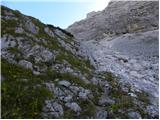 60
60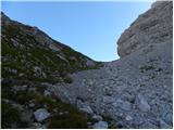 61
61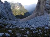 62
62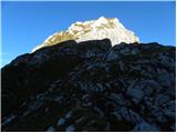 63
63 64
64 65
65 66
66 67
67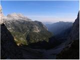 68
68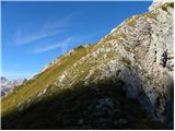 69
69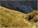 70
70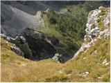 71
71 72
72 73
73 74
74 75
75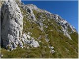 76
76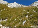 77
77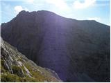 78
78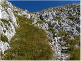 79
79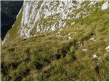 80
80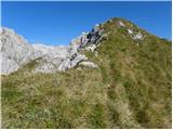 81
81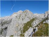 82
82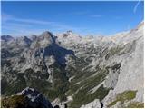 83
83 84
84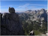 85
85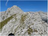 86
86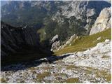 87
87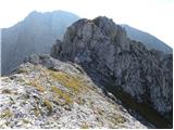 88
88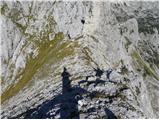 89
89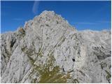 90
90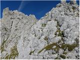 91
91 92
92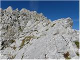 93
93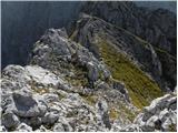 94
94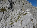 95
95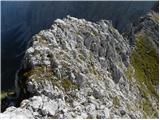 96
96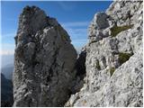 97
97 98
98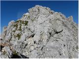 99
99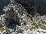 100
100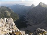 101
101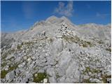 102
102