Golte (Alpine garden) - Ledenica na Golteh
Starting point: Golte (Alpine garden) (1386 m)
Starting point Lat/Lon: 46.37159°N 14.90102°E 
Time of walking: 15 min
Difficulty: easy marked way
Difficulty of skiing: no data
Altitude difference: 19 m
Altitude difference (by path): 40 m
Map: Kamniške in Savinjske Alpe 1:50.000
Access to starting point:
We drive to Mozirje, and then we follow the signs for Golte and Šmihel nad Mozirjem. When Mozirje ends at a road junction, we choose the right road leading towards Šmihel and further to Golte (the left road leads to the lower station of the cable car to Golte), and at all subsequent crossroads, we follow the signs for Golte. When we arrive at the parking lot by the once-maintained alpine garden, we park in a suitable spot.
Path description:
From the parking lot, we head onto a macadam road towards Mozirska koča na Golteh (sharply left hotel and Medvedjak, left Kolarica and Stari stani) and begin descending along mostly northern slopes of the peak Okence, a peak where an Alpine garden was once maintained. Lower down, we reach the chapel of Jesus the Good Shepherd on Mozirska planina, where the next marked crossroads is located.
We continue left over a grazing fence towards Smrekovec and Boskovec (straight to Mozirska koča na Golteh, 1 minute), and immediately after the grazing fence, the path splits again.
We choose the left path towards Smrekovec (slightly right Boskovec) and ascend diagonally into the forest. We continue by the clearing, where there is often heavy dew, and when we return to the forest, we notice signs for the ice cave, which we reach after a minute of further walking.
Description and pictures refer to the condition in June 2024.
Pictures:
 1
1 2
2 3
3 4
4 5
5 6
6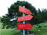 7
7 8
8 9
9 10
10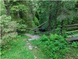 11
11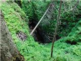 12
12