Gozd Martuljek - Rigljica (normal approach)
Starting point: Gozd Martuljek (750 m)
Starting point Lat/Lon: 46.4821°N 13.8378°E 
Path name: normal approach
Time of walking: 5 h
Difficulty: rock climbing ascent
Difficulty of skiing: no data
Altitude difference: 1324 m
Altitude difference (by path): 1500 m
Map: Kranjska Gora 1:30.000
Access to starting point:
From Mojstrana we drive towards Kranjska Gora or vice versa, but only to the village Gozd Martuljek, where we park on a parking lot near the bridge over the river Sava Dolinka (parking lot is located after the bridge, or before, if we come from Kranjska Gora).
Path description:
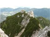
From Gozd Martuljek we go towards Kurji vrh. In the cirque below Rigljica at the boulder on which there is a sign PP we go left on the scree on the ridge between Kurji vrh and Rigljica. A walk on gravel could be very strenuous so we rather stick to the right side, on which runs a nice lane of dwarf pines. Without bigger problems we reach the ridge and from there otherwise rare cairns showing the further path. Barely noticeable footpath is winding on slopes above Pišenca, and sometimes the footpath goes also into northern walls. The footpath on which we are getting closer to the upper massif soon brings us into a notch, where an easy strolling ends.
The first mountain wall is approximately 100 meters high. We climb it straight, or slightly towards the right on a visible rift (easy - I. grade), on a plain we cross to the right around 30 meters and we go into the second wall. This route also sticks more to the right, orientation point can be a rounded rock, around which runs the route. We continue through the gully, where higher on the root of dwarf pine we run into an anchor for a descent, when we will return. From the root, we ascend slightly left and in a pleasant short climbing (II. grade) we reach the ridge of the secondary peak. On the ridge, we go towards the left to an anchor for a descent. From there we descend into a rough gully approximately 15 meters. In front of us there is steeply ascending the last barrier, which is detail of the tour. 20 meters of groove we have to climb, before we can clip into an anchor on a comfortable ledge. The most difficult part it is possible to bypass on the right. On a very exposed ledge and around the edge on leaned plates on the upper broken rocky slope (II. grade). But because we are principled, we are now standing on the ledge, and in front of us there is another wall, which we climb diagonally towards the right to huge rock, where there is an anchor for a descent. Now we have two options: first is on the right around the edge and on a rocky section into the upper crumbly rocky slope. The second option is for the brave: from the rock where we are standing towards the summit spans a distinct chimney. On the left flank it is completely broken so we need to climb right on an outside corner. Exposure is magnificent, rock crumbly. The chimney ends right at the top of a broken rocky slope. We are standing on a secondary peak of Rigljica, for approach to the summit, where there is an inscription box we need to descend to a crumbly outside corner, which we climb around it on the right. The main problems are over, to the top there is a pitch of a crumbly slope.
Rigljica is according to many the most difficult ascent, which can still be described in the mountaineering guide books. Because of the chimney detail, it reaches good III. grade. Detail is "equipped". The terrain is unclear and orientation difficult. We return on the ascent route. Anchors for a descent are settled and accessory ropes replaced. The tour is a rock climbing ascent III/II grade by UIAA. It is mandatory to be escorted by experienced mountaineer, if possible alpinist.
Equipment on this tour is self-evident.
For reflection: tour is possible to connect also with nearby Rušica.
From Rigljica we descend back to appropriate spot, where we go towards the large boulders. Past boulders to rezi Rušica and there through plates to the summit. Difficulties don't exceed II. grade. The tour is very wild and I strongly recommend it. For the descent from the peak of Rušica we return on the same path. Over the last spot we descend on a rope - settled descent.
Pictures:
 1
1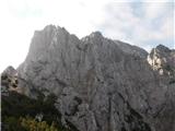 2
2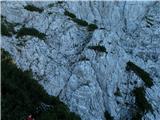 3
3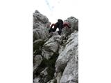 4
4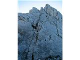 5
5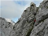 6
6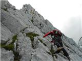 7
7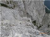 8
8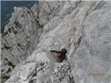 9
9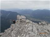 10
10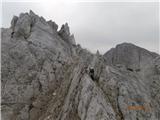 11
11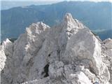 12
12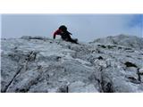 13
13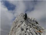 14
14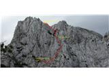 15
15 16
16