Hrušica - Dobršnik waterfalls
Starting point: Hrušica (615 m)
Starting point Lat/Lon: 46.449°N 14.0112°E 
Time of walking: 40 min
Difficulty: difficult pathless terrain
Difficulty of skiing: more demanding
Altitude difference: 185 m
Altitude difference (by path): 185 m
Map: Karavanke - osrednji del 1:50.000
Access to starting point:
From highway Ljubljana - Karawanks tunnel, we go to the last exit Hrušica, whereupon we turn right towards Jesenice. After few 100 meters of driving, we come to a crossroad, where we turn left uphill through a right turn. On top of the hill there is again a crossroad, where we again choose the left direction (here stands also a sign for Dobršnik). After additional 200 meters of driving on the right we notice a bus stop, and immediately after it, the road which branches off right towards the apartment blocks. Here, we park nearby on an appropriate place.
Path description:
From the parking lot (e.g.. on the right near the apartment block), we continue on the road which goes straight uphill through the right turn. And immediately at the top of the turn, we notice a road which runs in the direction towards the left among houses (street). We go in this direction, and after 100 meters (end of the street), we turn to the left on a hill downwards, almost to the stream. We don't cross it, but at the last house on the right we step on a cart track which runs into the forest (it seems like a private path). In the forest at the crossing we stick to the lower - left path, which runs by the stream. After few minutes walk, the path crosses the stream and despite it is ruined already in 20 minutes from the starting point, we reach the first 3 - level, 9 meters high waterfall, which is a little diagonally descending on the rocky terrain downwards.
On the left we can now notice the path which in two small zig-zags rises towards the rocks. We go there, and after few steps, we grab a rock next to it, so that we ascend to the top of the path which leads towards the second - 10 meters scenic waterfall. Next to it we will on the left wall notice the remains of teared fixed safety gear, and into a rock carved steps (don't try to climb, - wet rocks!).
We return back towards the first waterfall, but before we get closer to it, we turn right into a steep gully or with leaves covered scree - or landslide, which is rising more and more vertically. Here the path isn't visible, therefore it is best to look for traces of our predecessors. To the left, a little away from the mentioned landslide, walking is a little easier, therefore we rather continue there. On the steepness we will for quite some time still carefully ascending and avoiding wet roots of the trees, whereupon we will a little above the "landslide" notice a fallen beech trunk. Next to it we will now easier cross the steepness in the direction of right towards the edge of the canyon of the stream Dobršnik, which is winding deeply below us. Here on the edge, (+/- few meters) we carefully choose the vantage point. We will notice the waterfall a little above our horizon in the direction of north. At the descent, we will need a little bit of carefulness.
Pictures:
 1
1 2
2 3
3 4
4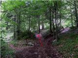 5
5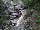 6
6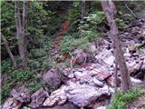 7
7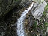 8
8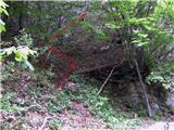 9
9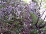 10
10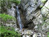 11
11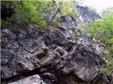 12
12 13
13 14
14 15
15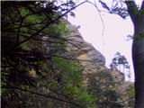 16
16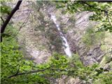 17
17