Kebelj - Dom na Osankarici (via Sveti Trije Kralji)
Starting point: Kebelj (717 m)
Starting point Lat/Lon: 46.4106°N 15.4529°E 
Path name: via Sveti Trije Kralji
Time of walking: 2 h 45 min
Difficulty: easy marked way
Difficulty of skiing: no data
Altitude difference: 476 m
Altitude difference (by path): 625 m
Map: Pohorje 1:50.000
Access to starting point:
We drive to Oplotnica (to here from the Štajerska motorway exit Slovenske Konjice or Slovenska Bistrica - south), then first we follow the signs for Osankarica, then for the settlement Kebelj. When we arrive in Kebelj from the center of the settlement, we turn left towards the cemetery, next to which we then park.
Path description:
From the parking lot, we continue on the road which leads us on the upper northern side of the cemetery, and when after approximately 50 meters the road ends we continue right on a marked path (left - Oplotnica).
The path ahead leads us on a marked cart track which before the entrance into the forest turns right and continues by the edge of the forest, from the mentioned cart track, blazes point us to the left on a narrow cart track which continues through the forest. Through the forest, we follow the blazes, and when the path turns a little to the right, after a shorter crossing from the right joins also the other path from the settlement Kebelj.
Here we go left and we quickly get to the ruins of Kebelj castle or Zajčev grad.
We bypass the ruins on the left side and we follow the blazes to the nearby asphalt road, where we go straight upwards. Only a little further, the asphalt road on which we continue turns right, and to the left the path branches off towards Osankarica (path Kebeljska transverzala). We leave the asphalt road only a little further, where signs for Črno jezero point us to the left into the forest. Next follows a shorter ascent through the forest and then past numerous pieces of litter we reach the nearby homestead (from the opposite direction there is also a warning for a dangerous dog). At the homestead, the road becomes asphalted and we quickly return on a somewhat wider asphalt road, on which we continue the ascent. After a few minutes, the blazes point us to the left on a grassy cart track, on which we ascend by the edge of the forest, and higher past the house we again step on the asphalt road which brings us to the next marked junction.
We continue right in the direction of Treh Kraljev and Črno jezero (left Črno jezero - path past Kos) and we continue on the road to a junction near the NOB monument.
From the junction, we go right towards the access road, and at the sign for dead-end street we go left on a marked footpath which continues through the forest. Next follows approximately 20 minutes of ascent through the forest, where we follow the blazes, and then we reach a road which we follow for some 10 steps to the right, where we arrive at Hotel Jakec, above which is the church of sv. Treh Kraljev.
From the church of sv. Treh Kraljev we continue in the direction of Črno jezero and Urškina poti and we quickly arrive at the nearby ski slope, along which we continue for a short time, then we cross it (during the operation of the ski slope we cross the ski run and lift higher - above the cableway and ski slope). The path ahead leads us past the ARSO weather station, we still follow the blazes, and on the connecting ski path in a few minutes we arrive also at another ski run, which we also cross (at the ski slope upwards Veliki vrh). Next follows also crossing a lift and another ski run, then the path enters the forest, where after a few minutes of further walking we arrive at a cross, by which stands the educational panel of Urškina poti. The path ahead slowly descends and brings us to a marked junction, where we choose the left path (straight Šumik and Ruška koča), where we continue in the direction of Osankarica and Črno jezero. Even further we descend gently to moderately and follow the blazes. When the descent ends we arrive at a junction near Črno jezero.
We continue straight (left Oplotnica - path past Kos) and in a few steps we arrive at the lake.
We follow the path ahead in the direction of Osankarica, so that we bypass the lake on the right side, and after crossing the stream, the path enters the forest and continues on a wooden-paved path. The path first continues without major changes in elevation, after some time it starts to descend visibly. We follow the paved path, which when wet is dangerous for slipping, all the way to the parking lot near Dom na Osankarici. From the parking lot, we cross the road and ascend to Dom na Osankarici, which burned down in 2021.
Kebelj - Zajčev grad 0:20, Zajčev grad - sv. Trije Kralji 1:20, sv. Trije Kralji - Črno jezero 0:50, Črno jezero - Osankarica 0:15.
Description and pictures refer to the condition in April 2022.
Pictures:
 1
1 2
2 3
3 4
4 5
5 6
6 7
7 8
8 9
9 10
10 11
11 12
12 13
13 14
14 15
15 16
16 17
17 18
18 19
19 20
20 21
21 22
22 23
23 24
24 25
25 26
26 27
27 28
28 29
29 30
30 31
31 32
32 33
33 34
34 35
35 36
36 37
37 38
38 39
39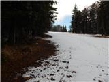 40
40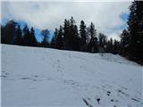 41
41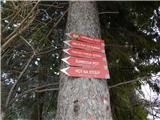 42
42 43
43 44
44 45
45 46
46 47
47 48
48 49
49 50
50 51
51 52
52 53
53 54
54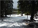 55
55 56
56 57
57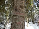 58
58 59
59 60
60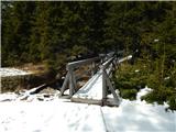 61
61 62
62 63
63 64
64 65
65 66
66 67
67 68
68 69
69 70
70