Korito / Coritis - Vrh Krnice
Starting point: Korito / Coritis (574 m)
Starting point Lat/Lon: 46.34879°N 13.39032°E 
Time of walking: 5 h 50 min
Difficulty: very difficult marked way
Ferrata: B/C
Difficulty of skiing: no data
Altitude difference: 1867 m
Altitude difference (by path): 1940 m
Map: Tabacco 27
Access to starting point:
Over the border crossing in Rateče we drive through Trbiž / Tarvisio. If we drive on the highway, we leave it at the exit for Tablja / Pontebba. We continue driving on the old road in the direction of Videm / Udine. In the settlement Na Bili / Resiutta we turn left towards the valley of Rezija (Val Resia). Further, we drive on a narrower asphalt road and follow the signs for the settlement Solbica / Stolvizza and then for the settlement Korito / Coritis. On a narrow and occasionally steep road, we drive towards the settlement Korito. About 500 meters before the village, a narrow road branches off to the left, where there are also signposts for path 657. We park near the crossroad.
Access is also possible on a narrow and winding road through the border crossing Učja.
Path description:
At the crossroad, we go left on a narrower road where signs point us to Ta Na Rawni and bivouac Marussich. At first, we slightly descend and cross stream Suhi Potok, which flows into the stream Rezija nearby. Some hundred meters further, we continue by the stream Rezija and also cross the stream Ronk. Here, the road turns to the right and starts ascending, and at the left turn, it brings us to a marked crossing.
Here, we leave the road and continue right on path 657, which runs near the mentioned stream. The path then turns to the left and starts ascending through the forest. Further, we ascend through the forest for quite some time, and only occasionally does a view open up slightly on the surrounding peaks. Higher up, we cross the mountain road and then follow a shorter ascent through the forest, which brings us to a smaller mountain pasture where a cottage is situated. The path leads us past the cottage and again brings us to the mountain road.
The path then leads for some time along the road and a footpath running near the road, which it also crosses several times. Higher up, we again join the mountain road, on which we continue for some time. Then, blazes point us to the right into the forest, and we finally leave the mountain road leading towards the mountain pasture Ta Na Rawni. Next follows an ascent through the forest on a less beaten path. Such a path soon brings us to a crossing where we join the path from the village Solbica / Stolvizza.
We continue right on path 634 in the direction of bivouac Marussich. From the crossing, we ascend diagonally through the forest for some time in the direction of east. A few more times, we ascend in zig-zags, and then the path emerges from the forest onto steeper, mostly grass-covered slopes. Further, for quite some time, we cross steep slopes towards the east and slightly descend. The slopes are quite steep, so some caution is occasionally needed at the crossing. From the path, we otherwise have a nice view of the Rezija valley and surrounding peaks. Such a path then brings us to a marked crossing at pasture Planina Grubje (Casera Grubia).
To the right, a transverse path 642/a branches off downwards towards Planina Kanin (Casera Canin), but we continue straight in the direction of bivouac Marussich. We start ascending again on a mostly grassy slope with a view of the precipitous walls of Vrh Krnice and Visoki Kanin. Further, we ascend on such a slope for quite some time, mostly in long zig-zags. On this path, we ascend all the way to the saddle Sella Grubia / Peravo, where bivouac Marussich is situated.
At the bivouac, we take path 632 in the direction of the mountain hut Rifugio Gilberti. We follow this path for only a few tens of meters and then go right on a slightly less visible footpath.
The crossing isn’t marked, but we will soon notice blazes in the shape of red triangles on the slope. The path soon brings us on a ridge and then few times slightly ascends and descends. Later, the path again avoids the ridge on the left side and a short ascent follows on the scree to the entry of a climbing part of the path.
At first, we ascend by the steel cable right upwards to the ridge from where a view opens up into a valley Rezija. On the ridge, we continue left and for a short time, we are ascending by the steel cable on a narrow ridge and then we again avoid the ridge on the northern side. Here the path becomes very steep and vertically ascends with the help of numerous stemples. Next follows some steep ascents by the steel cable and then we again come on the ridge. Further, the path is a little less secured, but on the key spots we still get help from a steel cable. We are mostly ascending by the ridge on the northern side, and occasionally the path runs also on the ridge. In the last part of the path towards Vrh Krnice path brings us on the south side of the ridge and to the top follows a shorter ascent on a little less steep slope.
Description and pictures refer to conditions in August 2024.
Pictures:
 1
1 2
2 3
3 4
4 5
5 6
6 7
7 8
8 9
9 10
10 11
11 12
12 13
13 14
14 15
15 16
16 17
17 18
18 19
19 20
20 21
21 22
22 23
23 24
24 25
25 26
26 27
27 28
28 29
29 30
30 31
31 32
32 33
33 34
34 35
35 36
36 37
37 38
38 39
39 40
40 41
41 42
42 43
43 44
44 45
45 46
46 47
47 48
48 49
49 50
50 51
51 52
52 53
53 54
54 55
55 56
56 57
57 58
58 59
59 60
60 61
61 62
62 63
63 64
64 65
65 66
66 67
67 68
68 69
69 70
70 71
71 72
72 73
73 74
74 75
75 76
76 77
77 78
78 79
79 80
80 81
81 82
82 83
83 84
84 85
85 86
86 87
87 88
88 89
89 90
90 91
91 92
92 93
93 94
94 95
95 96
96 97
97 98
98 99
99 100
100 101
101 102
102 103
103 104
104 105
105 106
106 107
107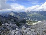 108
108