Kriška planina - Veliki Zvoh
Starting point: Kriška planina (1480 m)
Starting point Lat/Lon: 46.2929°N 14.5369°E 
Time of walking: 1 h 25 min
Difficulty: easy marked way
Difficulty of skiing: easily
Altitude difference: 491 m
Altitude difference (by path): 491 m
Map: Kamniške in Savinjske Alpe 1:50.000
Access to starting point:
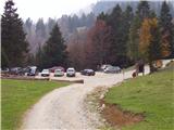
A) From highway Ljubljana - Jesenice we go to the exit Vodice, and then we continue driving to a first traffic light crossroad in Vodice, where we continue left in the direction of Cerklje na Gorenjskem and Brnik. When we get to the main roundabout in Spodnji Brnik we continue driving in the direction of Cerklje and ski slope Krvavec. At the end of the settlement Cerklje na Gorenjskem we leave the main road which continues towards Velesovo and Visoko and we continue driving slightly right on a road in the direction of the ski slope Krvavec. Further, we get to the village Grad, where signs for settlement Ambrož pod Krvavcem point us to the right on a steep asphalt road (straight bottom station of the cable car on Krvavec and Štefanja Gora). When the steepness on a steep road decreases a little, we will get to a crossroad, where we continue left in the direction of the settlement Ambrož pod Krvavcem (straight settlement Ravne, Apno and Šenturška Gora). A little further, the road for some time descends a little and then it is ascending through occasionally quite panoramic slopes. Higher, we get to Ambrož pod Krvavcem, where on the left side we bypass church of St. Ambrož and tourist farm Pr Ambružarju. From the tourist farm ahead road passes into the forest and is ascending through it all the way to the mountain pasture Jezerca, where there is a large parking lot. The road here flattens and it turns left and about 500 meters ahead brings us to a crossroad, where we continue right in the direction of the mountain pasture Kriška planina (straight upper station of the cable car and mountain hut Planinski dom on Gospincu). Next follows only a short steep ascent and we get to the parking lot by the edge of the mountain pasture Kriška planina.
Now the road from the mountain pasture Jezerca to Kriška planina is closed for public traffic, this extends the path for approximately 15 minutes.
B) From highway Jesenice - Ljubljana we go to the exit Kranj - east, and then we continue driving towards Brnik, Komenda and Mengeš. When we get to the main roundabout in Spodnji Brnik we continue driving in the direction of Cerklje and ski slope Krvavec. At the end of the settlement Cerklje na Gorenjskem we leave the main road which continues towards Velesovo and Visoko and we continue driving slightly right on a road in the direction of the ski slope Krvavec. Further, we get to the village Grad, where signs for settlement Ambrož pod Krvavcem point us to the right on a steep asphalt road (straight bottom station of the cable car on Krvavec and Štefanja Gora). When the steepness on a steep road decreases a little, we will get to a crossroad, where we continue left in the direction of the settlement Ambrož pod Krvavcem (straight settlement Ravne, Apno and Šenturška Gora). A little further, the road for some time descends a little and then it is ascending through occasionally quite panoramic slopes. Higher, we get to Ambrož pod Krvavcem, where on the left side we bypass church of St. Ambrož and tourist farm Pr Ambružarju. From the tourist farm ahead road passes into the forest and is ascending through it all the way to the mountain pasture Jezerca, where there is a large parking lot. The road here flattens and it turns left and about 500 meters ahead brings us to a crossroad, where we continue right in the direction of the mountain pasture Kriška planina (straight upper station of the cable car and mountain hut Planinski dom on Gospincu). Next follows only a short steep ascent and we get to the parking lot by the edge of the mountain pasture Kriška planina.
Now the road from the mountain pasture Jezerca to Kriška planina is closed for public traffic, this extends the path for approximately 15 minutes.
Path description:
From the parking lot, we go on a wide cart track which goes below the cableway and starts ascending over pastures (direction mountain hut Dom na Krvavcu). A moderately steep path after a little less than 30 minutes of walking, it brings us to the mountain hut Dom na Krvavcu from which a nice view opens up towards Gorenjska. From the mountain hut, we continue in the direction of Zvoh on the road which past the chapel and transmitters on Krvavec brings us to a saddle Razor (saddle between the peak Krvavec and Veliki Zvoh), where there is a crossroad of roads. We continue straight on the ridge (right peak Krvavec 5 minutes) and increasingly steep transport road which is occasionally paved, we follow by the edge of the ski track to an artificial lake on Veliki Zvoh. From the lake, we ascend also on the nearby peak, and then over a wire fence we walk to the inscription box, which is situated only few steps below the summit.
Pictures:
 1
1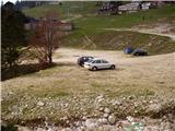 2
2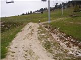 3
3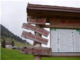 4
4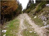 5
5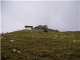 6
6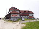 7
7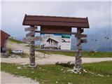 8
8 9
9 10
10 11
11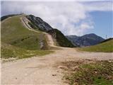 12
12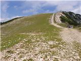 13
13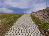 14
14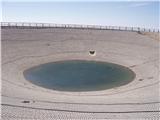 15
15 16
16