Ljubelj - Begunjščica (via Zelenica)
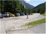
Starting point: Ljubelj (1058 m)
| Latitude/Longitude: | 46,4324°N 14,2602°E |
| |
Route name: via Zelenica
Walking time: 3 h 50 min
Difficulty: partly demanding marked way
Elevation gain: 1002 m
Elevation difference along the route: 1100 m
Map: Karavanke - osrednji del 1:50.000
Recommended equipment (summer): helmet
Recommended equipment (winter): helmet, ice axe, crampons
Views: 157.921
 | 10 people like this post |
Access to starting point:
From the highway Ljubljana - Jesenice we go to the exit Ljubelj and follow the road ahead to the border crossing. Only a few meters before the border crossing signs for Zelenica point us to the left and after a few 10 meters of additional driving the road brings us to the parking lot below the ski center Zelenica.
Route description:
From the parking lot, we go on a footpath in the direction of Zelenica, Vrtača and Stol. Cart track which runs on the left side of the ski track, after approximately 15 minutes of a moderate ascent through the forest brings us to the before-mentioned track by which we are then ascending. The path which offers nice views on extensive scree of Begunjščica on the left and to a ridge of Ljubeljščica on the right then in a gentle ascent brings us to the hut on Vrtača.
From the mountain hut, we continue straight on a marked path, which slowly turns slightly to the left and after a shorter diagonal ascent brings us into a lane of dwarf pines. Further, the path is for a short time steeply ascending and then brings us on a cart track (transport road), which we follow in a moderate ascent to the mountain hut Dom na Zelenici.
While ski track operates it is forbidden to walk on a ski slope. At that time we use the winter path which runs on a transport road.
From the hut, we continue left in the direction of Begunjščica and mountain hut Roblekov dom on the path which through a lane of a forest and dwarf pines brings us below the scree of Begunjščica. On the other side of the scree, over which leads a nicely routed path, we come in a lane of dwarf pines. Here we start ascending steeper on the path which offers nice views on surrounding peaks. On the top of the ascent, which lasts approximately 20 minutes, we step on a distinct side ridge of Begunjščica. The path ahead crosses relatively steep slopes, and then after a short descent, we step on extensive scree of Smokuški plaz. Next follows crossing of the mentioned scree, and the path then again passes on steep slopes. Next follows a diagonal ascent on slopes, which are partly covered with dwarf pines. On this part we run into a short, slightly harder passage, over which we get help from a steel cable, which is useful, when the path is wet. Occasionally a little steeper path, then with increasingly beautiful views brings us on the main ridge of Begunjščica, where we get to another in dry barely needed steel cable. Next follows few steps long descent and the path brings us to a crossing, where we continue left upwards in the direction of Veliki vrh on Begunjščica. The path ahead is ascending diagonally, on in parts quite steep southern slopes of Begunjščica. The transverse path, which offers nice views on Gorenjska has in the upper part a larger number of orientational loops. Because of large number of hikers and sheep in the upper part there are numerous footpaths, which can quickly lead away from the right path. To not go astray, which in fog can quickly happen, we stick to the left (upper) otherwise very poorly marked path. The path which is in wet also dangerous for slipping, then finally brings us on a panoramic peak.
Ljubelj - Zelenica 1:20, Zelenica - Begunjščica 2:30.

Photos:
 1
1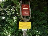 2
2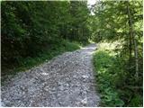 3
3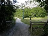 4
4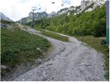 5
5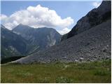 6
6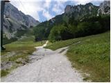 7
7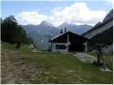 8
8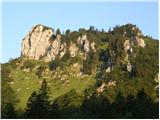 9
9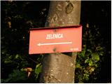 10
10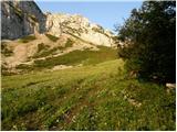 11
11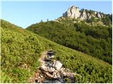 12
12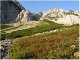 13
13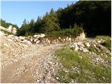 14
14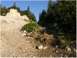 15
15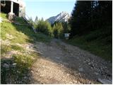 16
16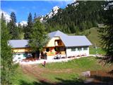 17
17 18
18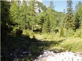 19
19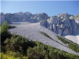 20
20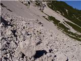 21
21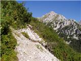 22
22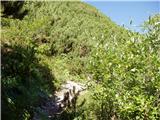 23
23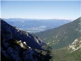 24
24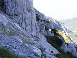 25
25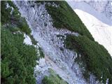 26
26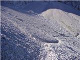 27
27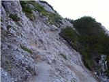 28
28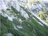 29
29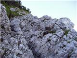 30
30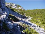 31
31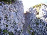 32
32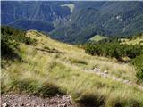 33
33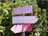 34
34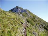 35
35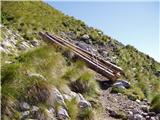 36
36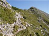 37
37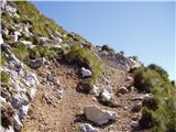 38
38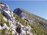 39
39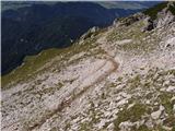 40
40 41
41
Discussion about the trip Ljubelj - Begunjščica (via Zelenica)
Show older messages
|
| Gost11. 08. 2006 |
very beautiful trip in sunny weather
|
|
|
|
| Gost17. 08. 2006 |
This is, at least in my experience, the most picturesque approach to Begunjščica. But I don't know when it's more beautiful: June and July when everything is blooming, or in autumn when the larches turn golden.
MiR
|
|
|
|
| Gost23. 08. 2006 |
Who knows what's up with that Garni Hotel on Ljubelj?
|
|
|
|
| majdicst11. 08. 2008 |
Yesterday (10 August 2008) we ascended Begunjščica via this trail. Unfortunately fog accompanied us on the way, so there weren't many views, but nevertheless I agree that this approach is extremely picturesque, especially crossing the scree on the northwestern side of the ridge. It's not the easiest, but there is no real difficulty on the trail, except that the last part under the summit, which due to numerous sheep paths is hard to recognize and thus ideal to get lost. Markings are sparsely placed, and quite faded. On the summit we heard from some visitors that they wandered under the summit for quite some time looking for the right path.
On the summit the sun greeted us for a while and the mists on the north side cleared for a while, but sadly not on the south. No special crowd, despite the favorable weather forecast.
We returned via planina Preval(a)(sometimes written Preval - also in the guidebook; on the hut it's PREVAL-a, on the stamp Koča na Prevali) and through Bornov tunnel back to Ljubelj.
|
|
|
|
| Tadej20. 08. 2008 |
The path to Begunjščica from Roblekov dom and Dom na Zelenici will soon be renovated (I don't know exactly when, but they have already started the works (logs have been brought)). This will solve the orientation problems that more and more hikers have recently due to the greater number of small paths. The new renovation of the path will also reduce the risk of slipping.
|
|
|
|
| heinz4. 10. 2008 |
I wonder if the summit of Begunjščica could currently be reached without winter gear (crampons..)
Is any path trodden to bare ground
|
|
|
|
| Leon8112. 08. 2009 |
I've been thinking for a while about a similar tour to the one done by 'majdicst', but in the opposite direction: via Bornove tunnels and Prevalo to the top and descent via Zelenica. Which direction seems more suitable to you?
Best, Leon
|
|
|
|
| štempilka12. 08. 2009 |
To me the one via Zelenica seems nicer. Although this one drags a bit too. Of course Prevalo and onwards via Kalvarija is also very nice, and quite steep. Both directions are fine. Via Zelenica is good because there is a lot of scree, especially for descent. The decision is yours. Good luck and lots of beautiful views.
|
|
|
|
| LukaMl31. 05. 2010 |
I'm wondering how long the walk from Roblekov dom to Begunjščica is. I'm considering a circular tour via dom na Zelenici, Roblekov dom and over Begunjščica back to Zelenica. It's probably a fairly common route, but there's no description of it.
|
|
|
|
| grega_p31. 05. 2010 |
There are more options to Roblekov dom and Begunjščica. You can go along the path described above (Ljubelj - Zelenica 1:20, Zelenica - Begunjščica 2:30), or decide to continue towards the dom at the source of Završnica, descend about 200 meters elevation and turn left towards Roblek (that will take approx. 1:30h) or along the nice Bornova path via Prevala http://www.hribi.net/izlet/ljubelj_roblekov_dom_na_begunjscici_cez_preval-o/11/195/610.
From Roblek to the top of Begunjščica is 1h or a bit more. However, according to today's observation, it snowed somewhere above 1800m. Probably just a dusting but still - caution is not superfluous. I recommend calling Roblek for conditions 051/ 323 402, info 04/ 53 15 544
|
|
|
|
| LukaMl1. 06. 2010 |
Grega thanks for the quick reply and useful information. Regarding the weather, we'll really have to wait a bit to decide what to do.
|
|
|
|
| Planinček19. 05. 2011 |
On Sunday I plan to go to Begunjščica via this path. I'm interested if there is still snow anywhere.
|
|
|
|
| Matjaz_654. 09. 2011 |
a few more of my pics ... with ascent via Smokuška planina and Roblek ... and descent via Preval and through Bornov tunnel 
|
|
|
|
| Janiel747. 09. 2011 |
I would like to ask for advice:
I plan to go to Begunjščica from Ljubelj (passing by Zelenica and Roblekov dom on the way) - Yes. Also for the stamps in the SPP booklet. I read that the path via Preval and Bornov tunnel is nice..maybe return from Begunjščica via that path??
What suggestion? thanks
|
|
|
|
| Janiel747. 09. 2011 |
One more thing: are those two huts open also on Fridays?
|
|
|
|
| GregorC7. 09. 2011 |
If you return via Preval and through Bornov tunnel, you make a nice loop. From the summit of Begunjščica via Kalvarija descend to Preval and from there to Ljubelj. This descent can be a bit tricky, especially when wet. Alternatively, go to the summit first and return to Roblekov dom and from there to Preval. It's somewhat easier. Both variants are nicer than returning the same way. The huts are probably open (still) every day until mid-month. And I think there's also a mountain hut open at Preval. LP
|
|
|
|
| JUREE7. 09. 2011 |
Hello
For me, the nicest way to Begunjščica from Ljubelj is via Zelenica and on the way back to Roblekov dom and then via Preval and Bornov tunnel back to Ljubelj.
Until the end of the mountaineering season, both huts are open every day, after the season I think the caretakers are at Roblekov dom already on Fridays, on Zelenica I almost don't believe.
Best to ask beforehand. List of huts with phones at:
http://www.pzs.si/index.php?stran=Seznam%20ko%E8
|
|
|
|
| Janiel747. 09. 2011 |
Thanks for the info. I'll go that loop trail 
|
|
|
|
| Janiel7410. 09. 2011 |
Super trail this is. Very easy actually, a bit for relaxation but with very nice views. I went circular via Prevala, up via Roblek, then down via Zelenica... only a bit fog was playing from Prevala to Roblek.
|
|
|
|
| pelican10. 09. 2011 |
I was also yesterday on the circular, but from the other side... fog on Begunjščica all day...
|
|
|
|
| Lunca10. 09. 2011 |
Is it well marked, we plan to go tomorrow for the first time, so we don't get lost... I'm also interested in this circular, L - Zelenica - RD - Prevala - L?
|
|
|
|
| Alni27. 07. 2012 |
Is the path suitable for beginners?
|
|
|
|
| jprim27. 07. 2012 |
Alni, you still don't know or don't dare to make decisions without comments...
Become more independent! It's fine to ask sometimes, but for everything... self-confidence is important.
But anyway, .... it's suitable, but I would recommend this to you (you won't regret it)
Ljubelj - via Bornove tunnels - planina Preval - towards the summit, via Kalvarija; to try a slightly steeper path, - Roblekov dom - then back to Preval.
It is true that you can choose another path from Roblek towards Završnica valley, but that one is harder.
Cheers!
|
|
|
|
| Kriška28. 07. 2012 |
Is this happening only to me (or my computer), or is there something wrong with the captions under the photos in general? When viewing them, I see the captions "lagging"?
|
|
|
|
| amarilis28. 07. 2012 |
Iprim
Alni, you recommend the path from Roblek towards Završnica valley. It didn't seem harder to me, we just walked a bit longer than in the guidebook. Lp
|
|
|
|
| Pohodnica5628. 07. 2012 |
I agree with jprim. It also says partially difficult on hribi.net. Although sometimes many disagree with these markings. But don't forget, Alni is asking if it's suitable for beginners!? At least I've gathered some mileage on not very exposed places or crossings of steep slopes that can be dangerous when wet, sometimes dealing with vertigo too.......etc. I won't ramble on, but years ago a good friend who climbed all peaks and smaller hills told me: remember, no path is easy even if it says so, prepare well for every one, even if just going to Šmarna gora. Wishing everyone many more beautiful moments in the mountains and safe steps.
|
|
|
|
| Pohodnica5628. 07. 2012 |
@Kriška: I noticed a couple of days ago that they are lagging.
|
|
|
|
| darh28. 07. 2012 |
We went to Begunjščica today via this path, back via Preval and Bornova pot. Wonderful weather and nice views, just one degree less wouldn't hurt. Here are some more impressions and photos.
|
|
|
|
| aboc17. 08. 2012 |
On 3.8.2012, my husband and I did a circular route: Ljubelj - Dom na Zelenici - Veliki vrh - Roblekov dom - Dom na Prevali - Ljubelj (Bournova pot). The trip is gorgeous, offering views of Vrtača, Stol, Gorenjska with Lake Bled. The path is varied and diverse. On scree slopes, alpine poppies bloom, from rock crevices peek Zois' violets and Triglav pinks. From Prevala towards Ljubelj, the Bournova pot is poorly marked - a few minutes into the hike, the path splits, follow the left, upper branch. We will definitely repeat the trip in full composition.
|
|
|
|
| jota!22. 08. 2012 |
We too did the above-described circular trail a few days ago and returned enthusiastic. We walked the trail in the estimated time (we are just average hikers).
The trail from Zelenica to the ridge is on the S side of the mountain, so walking is in pleasant shade. At the beginning of the trail from Zelenica it's a bit slippery because of that. The trail through the scree is excellently secured.
We were also impressed by the trail from Prevala through Bornovi tunnels back to Ljubelj. A really pleasant 0.5-1m wide path that descends gradually. This part of the trail in the opposite direction (Ljubelj-Prevala) seems suitable to us also for somewhat older hikers, because the ascent is really gradual. But it's true that it's not suitable for those with vertigo and that it's exposed in a few places (cable).
|
|
|
|
| dsusnik30. 07. 2013 |
On 27.7.2013 my wife and I did a circular route: Ljubelj - Dom na Zelenici - Veliki vrh - Roblekov dom - Dom na Prevali - Ljubelj (Bournova pot). Very nice trip-I recommend it!
|
|
|
|
| naroblek14. 08. 2013 |
dsusnik@
My wife and I are thinking about exactly such a trip.
How much time did this trip take? Thanks. LP
|
|
|
|
| @rekar14. 08. 2013 |
@naroblek, this trip is 5-6 hours
|
|
|
|
| jimi&co2. 09. 2013 |
On Friday we set off from Ljubelj, through the tunnels to the Prevale pasture. We treated ourselves to an excellent jota (for štruklji we would have had to wait half an hour, but no time), which helped us so that the Calvary was a small snack. Interesting how many cow pats you find on the slope. Those must really be alpine cows ;-)
Well, the path from Ljubelj to Prevale can be a great family trip, especially for children who want to see cows up close ;-) The path is not demanding, but very pleasant.
At the top of Begunjščica there is a beautiful view in all directions. The path to the junction between Zelenica and Roblekov dom passes quickly, while the path to Zelenica drags a bit. Well, fatigue probably does its thing ;-) From last year's hike from Zelenica to Roblekov dom and back we remembered it more fondly. Since we overnighted at Zelenica (a real hotel in the mountains ;-) the hot shower was extremely pleasant and welcome ;-)
For the whole path, including stop at Prevale, intermediate admiring the surroundings, photographing... we needed about 6 hours.
On the way a runner overtook us  , and overhead flew a huge glider. Well, that's how it seemed to us. Otherwise on the path, except sheep we met no one. , and overhead flew a huge glider. Well, that's how it seemed to us. Otherwise on the path, except sheep we met no one.
|
|
|
|
| PepsiNina28. 02. 2014 |
I wonder if the trail is suitable for a dog? Not physically demanding but technically.
|
|
|
|
| Daaam28. 02. 2014 |
I think those two wire ropes shouldn't be a problem for a dog.. so go ahead boldly
|
|
|
|
| U&Q28. 02. 2014 |
I went on this trail with my dog and she had no problems at all. If the dog is used to walking on scree and rocks, there shouldn't be any issues.
|
|
|
|
| Lunatic28. 02. 2014 |
Our Dalmatian has been up over Kalvarija twice and down here to Zelenica b.p., but at this wire rope it's still easier for the dog to go up than down...
|
|
|
|
| capraibex1. 03. 2014 |
No dog is really happy if its owner drags it along such a demanding trail, some people really have no measure.
|
|
|
|
| Daaam1. 03. 2014 |
A dog is probably much happier on such a trail than if the owner takes it on the usual daily circle around the block
|
|
|
|
| katja8710. 06. 2014 |
On Saturday, 7.6.2014, we did a circular tour to Begunjščica: Ljubelj - Dom na Zelenici - Begunjščica - Roblekov dom na Begunjščici - Planina Preval-a (čez Rožo) - Bornova pot in tuneli - Ljubelj.
The entire path is dry, except for crossing one snowfield right after Dom na Zelenici, which is not problematic and is normally passable.
We had a wonderful day and beautiful views. There were quite a few hikers at the summit and most of them, like us, enjoyed it up there for a whole hour 
Pictures from the tour can be viewed on the website of Planinsko društvo Matica Murska Sobota: http://www.mojalbum.com/pdmaticams/20140607-begunjscica-krozna-pot/pot-pod-zicnico/21759749
|
|
|
|
| matttt24. 06. 2014 |
I'm interested if anyone knows if it's possible to descend from the top of Begunjščica into the valley via one of the screes, specifically on the Zelenica ski slope side. (of course in summer) I myself don't distinguish well between scree Y, central, ... The scree that comes down to the valley above the koča na Vrtači interests me. Thanks
|
|
|
|
| Macesna24. 06. 2014 |
In summer it's possible to descend to the valley via the Šentanski plaz. The Y and Centralna screes you mention have jumps (climbing!) and in dry conditions they are not enjoyable. Even the Šentanski plaz (the largest and widest scree between the first (Koča Vrtača) and second station of the former single chairlift is not that great - unpleasant, rocks, steep. The best and least strenuous is still along the marked paths.
|
|
|
|
| AdryBK27. 06. 2014 |
Hi, I'm interested in how difficult the path through the bushes (Zelenica-Begunjščica) is, is it passable for any hiker without extra equipment? Thanks for clarification.
Question - is Roblek hut already open?
thanks, best regards
|
|
|
|
| Bojan_A27. 06. 2014 |
The path is easy, there is a wire cable in between, but it poses no difficulties. Roblek is open.
|
|
|
|
| pemi28. 06. 2014 |
AdryBk I walked this path in the opposite direction with my dog, so no major difficulties nice one
|
|
|
|
| smatjaz28. 06. 2014 |
AdryBK, the path from this side is quite strenuous due to scree and partially damaged sections (first-hand info as I was up there last weekend). I might rather recommend Born's path to Preval, Roblek and then down this side, it seemed easier to me overall. In no case do you need extra gear, although a helmet is recommended for crossing the scree as stones still occasionally come down from above. Roblek, hut at Preval and Zelenica open.
|
|
|
|
| matttt18. 07. 2014 |
Today I did a circular tour Ljubelj-Zelenica-Begunjščica-Roblek-Prevala-Ljubelj. The approach to Begunjščica from the Zelenica side is definitely the most beautiful for me. The path is not excessively demanding, but also not so easy that I would, for example, take my dog with me on this path. The path is entirely dry and normally passable. Good luck
|
|
|
|
| zabava19. 07. 2014 |
I just came home from a trip to Begunjščica, via Zelenica, then to Roblekov dom, Prevala, Ljubelj. Great day. The path was a bit tiring for me, but now that I'm home, I can say it was fantastic. Anyway, for every hill, let alone a mountain, you have to make a little effort.
|
|
|
|
| griff19. 08. 2014 |
Yesterday I did a circular route with my dog. Ljubelj-Zelenica-Begunjščica-Roblek-Prevala-Ljubelj. For the dog, only the section from Zelenica to Begunjščica where the first chimneys are is difficult. Depending on the dog's size, it needs assistance there because with an improper jump onto the rock it can slip off... Wonderful trail :-)
|
|
|
|
| mala paklenica2. 07. 2015 |
Is a helmet needed for the descent from Begunjščica to Zelenica?
The trail description on hribi.net says it's recommended, same for the ascent via Bornova pot over planina Preval so I carried it but didn't use it.
Lp
|
|
|
|
| robter2. 07. 2015 |
LG, tell the guy he doesn't need it, don't burden him with what's recommended and what isn't.
I'm curious how many times you used it on the path from Zelenica to Roblek.
Water bottle, as LG says it's recommended, but you don't need it.
|
|
|
|
| viharnik2. 07. 2015 |
Above the rockier steep slopes, it's good to use a helmet everywhere, because if a person doesn't trigger it, chamois often do. As stated by GRS, the helmet is also used on all difficult paths, snowfields, steep grass where there is an increased risk of slipping. Finally, in summer the helmet also protects us from excessive head overheating.
|
|
|
|
| ljubitelj gora2. 07. 2015 |
@robter no need to complicate , it says it's recommended, but if you fall on scree it comes in very handy. Everyone decides for themselves where to carry the helmet. , it says it's recommended, but if you fall on scree it comes in very handy. Everyone decides for themselves where to carry the helmet.
|
|
|
|
| robter2. 07. 2015 |
LG I'm not complicating. He knew your answer since he read it on the internet and now asks if he actually needs something.
Clear question and clear answer. And safe step forward.
|
|
|
|
| jax2. 07. 2015 |
@viharnik, I hope you don't think a helmet would help in such a rockfall.
|
|
|
|
| viharnik2. 07. 2015 |
Here only the third sense protects you by not being at such a place, as it's similar to the recent earthquake in Nepal.
Just today Silvo and I talked about how some people maximally expose themselves continuously, prove themselves and often walk on the edge of the limit. He says it's always good to hold back at least some 10% and that in all everyday matters, not just in mountains. Danger always lurks everywhere if you're not 100% focused. Sometimes you feel that the current collective energies don't allow any major activities, neither in traffic nor elsewhere, better to stay home then.
Interestingly, an acquaintance farmer, otherwise very healthy in his 50s, who works only on the farm and isn't involved in worldly life, told me that some days he feels completely awful, without energy and will to work, the next day as if there was nothing. He also hikes quite a bit in the mountains and has good fitness. Yes, from yoga we know that in this transitional time in Satja Yuga many things are energetically cleansing, negativity comes to the surface, hence such fluctuations in a person's mood (you can be pure, but it still affects you, much less in a meditation center). Helps a foot bath with coarse sea salt, gazing at a candle flame or the earth, nature.
|
|
|
|
| zlatica5. 07. 2015 |
little paklenica@, nice contribution from our mountains
|
|
|
|
| Ajda_Zitnik6. 07. 2015 |
Yesterday I ascended to Begunjščica via this path. To the description I would only add that the markers have now started to mark the path with wooden poles, so following the path is also easier (you follow the poles, there are still few marks).
|
|
|
|
| dalibor_z19. 07. 2016 |
Ajda, was there still any snow on the path? Or is the path completely dry? We plan to go up on Thursday 21.7.
|
|
|
|
| mihajlovich11220. 07. 2016 |
No sign of snow anywhere, was up there on Sunday via this path.
lP
|
|
|
|
| modrook1221. 05. 2017 |
I'm wondering if there's still any snow on this path? On Sunday we'd like to do a trip.
|
|
|
|
| pikica121. 05. 2017 |
Just go hiking, the path is dry.
Regards.
|
|
|
|
| vladika13. 08. 2017 |
Yesterday I also headed out on the circular path Ljubelj - Zelenica - Begunjščica - Preval - Ljubelj. Six hours of enjoyment. Let me add that if anyone goes from Planina Preval to Begunjščica on the path čez Kalvarijo (I met quite a few), the path is really steep and strenuous. Otherwise the path is very nice from both directions and I recommend it to everyone.
Pictures can be found here.
Safe steps everyone, Vlado
|
|
|
|
| Sujcic24. 06. 2018 |
Is there still any snow on this trail?
|
|
|
|
| coupet11. 06. 2019 |
Is this the most beautiful path to Begunjščica in your opinion? Can it be done as a loop past Roblekov dom?
Regards
|
|
|
|
| djimuzl11. 06. 2019 |
Three circular variants:
1) Ljubelj - Prevala - Begunjska Vrtača - Veliki vrh - Roblekov dom - Prevala - Ljubelj
2) Ljubelj - Prevala - Begunjska Vrtača - Veliki vrh - (Roblek) - Zelenica - Ljubelj (possible descent to Roblek adds another 150 meters of descent and ascent)
3) Ljubelj - Prevala - Begunjska Vrtača - Veliki vrh - Roblekov dom - Tinčkova koča - Dom pri izviru Završnice - Zelenica - Ljubelj (long...)
And there are more..
|
|
|
|
| @rekar12. 06. 2019 |
If you go once over Prevala it's easier for you, Prevala Roblekov dom and Veliki vrh, from the top you can go to Zelenica along the trail or descend directly over the scree of Šentanski plac.
|
|
|
|
| robbrt28. 07. 2019 |
On Friday we went with my girlfriend on this trail. The trail to Zelenica is pure poetry, further to the top through bushes also very nice, then it becomes at times very unpleasant. The trail is crumbly, crosses steep gullies and scree and then ascends the slope towards the ridge on slightly exposed terrain, wire ropes would be welcome in some sections, but there are none  On this part the trail is demanding, otherwise moderately demanding trail is appropriate difficulty. Best regards On this part the trail is demanding, otherwise moderately demanding trail is appropriate difficulty. Best regards
|
|
|
|
| edelweiss9611. 08. 2019 |
Beautiful trail, especially the section between Zelenica and the junction between the summit and Roblek is excellent, views exceptional. We'll be back!
|
|
|
|
| hribolazecales17. 08. 2019 |
For those afraid of heights: this path certainly isn't the first choice (especially not for descent) - the path is quite exposed in many places, a wire would be suitable but there isn't one (need to grip the rock). The easiest path to Begunjščica goes past Roblekov dom.
|
|
|
|
| Perosu124. 06. 2020 |
Yesterday, 23.6 glasses found below the summit - they are at Kompas on Ljubelj
|
|
|
|
| modrook1228. 05. 2021 21:28:51 |
What are the conditions like on this trail? How much snow is still left at the top? Regards
|
|
|
|
| Vizjo7. 06. 2021 20:51:44 |
Hello, has anyone walked the path from Ljubelj over Zelenica to Begunjščica in the last few days? What are the conditions on the path? Is it snow-free or only passable with winter gear. Thanks and best regards,
Vizjo
|
|
|
|
| glorija30. 06. 2021 06:02:02 |
Since we did from Zelenica to Begunjščica, past Roblek to Prevala, it's well marked up to here ..From Prevala towards Ljubelj it's by nose, very poorly marked where trails intertwine with paths and you don't know where.. Several of us didn't know where in this direction, maybe it's easier in the opposite direction to reach Prevala. There was only one snow patch a bit above Zelenica where winter gear is not needed... safe steps
|
|
|
To post a comment you must log in:
If you do not yet have a username, you must first
register.