Starting point: Mislinja (630 m)
Starting point Lat/Lon: 46.44837°N 15.1946°E 
Time of walking: 2 h 30 min
Difficulty: easy marked way
Difficulty of skiing: easily
Altitude difference: 913 m
Altitude difference (by path): 913 m
Map: Pohorje 1:50.000
Access to starting point:
Access from Velenje: We drive towards Slovenj Gradec to Mislinja. In Mislinja road with signs Mislinjski graben branches off to the right. Here we continue straight towards Slovenj Gradec few ten meters to the spot, where on the left side of the road, we notice gas station. Only few meters before the gas station, we turn right and we follow the road to the next crossroad. We continue straight and we drive for some 100m to the parking lot at signposts for Črni vrh.
Access from Slovenj Gradec: We drive towards Velenje to the village Mislinja. Here immediately behind the gas station, we turn left. Further, follow the upper description.
Path description:
At the end of the parking lot signpost points us to the right on a narrow cart track which soon turns left and changes into a barely visible footpath. The path then ascends through a meadow and past a smaller hamlet brings us on an asphalt road. The path only crosses the road, and then it is ascending on a cart track which out of the forest soon brings us on the edge of the forest. Here, the footpath again vanishes but the path is marked, so that it is easier to find the right direction, which runs on the right side of a meadow. The path brings us to the next smaller hamlet after which the path goes into the forest and ascends steeper. This ascent also doesn't last long, because we are soon at the next house. Behind the house, we cross the forest road and then we are ascending on a cart track which a little higher brings us on the forest road at the next hamlet. Further, we continue on a gently sloping road which at the chapel joins "main road". To here we can also come on the road and in doing so, we avoid orientational problems and dogs, which bark, when we walk past houses.
Here we continue left on the road upwards only for few meters to the spot, where signposts point us to the right upward. The path at first crosses a nice panoramic meadow, and then goes into the forest, where it continues on a cart track. Cart track soon turns into a footpath which a little higher again brings us on the forest road.
Next follows a little longer walk on the road to the spot, where the marked path on Črni vrh branches off to the left upwards. We go on this path, which soon crosses a forest road behind which our path starts ascending steeper. A little higher we again cross the forest road behind which we run into a pleasant resting place (bench and table). Only a little further, the path brings us to a crossing, where we continue straight in the direction of Črni vrh 20 minutes. The path ahead steeply ascends and a little below the summit it brings us to a well after which the forest becomes quite thin. Next follows a shorter gently sloping ascent on the upper slope of Črni vrh which we reach without problems.
Pictures:
 1
1 2
2 3
3 4
4 5
5 6
6 7
7 8
8 9
9 10
10 11
11 12
12 13
13 14
14 15
15 16
16 17
17 18
18 19
19 20
20 21
21 22
22 23
23 24
24 25
25 26
26 27
27 28
28 29
29 30
30 31
31 32
32 33
33 34
34 35
35 36
36 37
37 38
38 39
39 40
40 41
41 42
42 43
43 44
44 45
45 46
46 47
47 48
48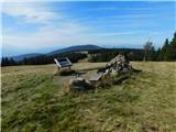 49
49