Nuskova - Serdiški breg (Rdeči breg)
Starting point: Nuskova (237 m)
Starting point Lat/Lon: 46.81065°N 16.02895°E 
Time of walking: 50 min
Difficulty: easy marked way
Difficulty of skiing: no data
Altitude difference: 179 m
Altitude difference (by path): 185 m
Map: Pomurje 1:40.000
Access to starting point:
We drive to Gederovci (to here from Murska Sobota or Radenci), then we continue driving towards Kuzma. After Rogašovci we arrive in Nuskova, a little past the road sign which marks the end of the settlement Nuskova, we turn left onto the nearby parking lot, which is situated by the main road. We park on the part of the parking lot which is by the main road; the other part is intended for buses.
Path description:
At the parking lot, signs for the path Vrbova pot and Slatinski vrelec (mineral water spring) direct us onto a side road which continues towards the west. The gentle road soon crosses the river Ledava; a little ahead, from the crossroad we go right onto a macadam road, where signs for the mineral water spring (Slatinski vrelec) also direct us. We quickly leave the macadam road and go left over a small bridge, then along a tree-lined avenue we continue to the mineral water spring Nuskova.
From the mineral water spring we return to the macadam road, then continue along it towards the north. We continue with easy walking, passing the football field; after the field, by the fire station, we reach an asphalt road. From the crossroad by the fire station we continue left and follow the blazes. The path ahead starts to ascend along the asphalt road and leads us past a few houses. Higher up, we arrive at a small saddle, where the marked path to Serdiški breg turns right, and to the left branches off the path to Beli breg.
We continue right towards Serdiški breg (straight down to Ocinje), where with nice views we continue past a few houses. Further on, the road becomes steeper, still leading us past occasional houses. Higher up we arrive at a smaller crossroad, where we continue left onto the side road, beside which we notice a traffic sign prohibiting lorries over 7.5 tonnes. We continue along the mentioned road, which in a few minutes of further ascent brings us to Serdiški breg, from which a nice view opens up.
The description refers to the condition in August 2021, and the pictures are from March and August 2021.
Pictures:
 1
1 2
2 3
3 4
4 5
5 6
6 7
7 8
8 9
9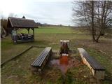 10
10 11
11 12
12 13
13 14
14 15
15 16
16 17
17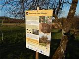 18
18 19
19 20
20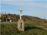 21
21 22
22 23
23 24
24 25
25 26
26 27
27 28
28 29
29 30
30 31
31 32
32 33
33 34
34