Pichla bei Radkersburg - Königsberg
Starting point: Pichla bei Radkersburg (263 m)
| Latitude/Longitude: | 46,79252°N 15,95960°E |
| |
Walking time: 40 min
Difficulty: easy marked way
Elevation gain: 199 m
Elevation difference along the route: 199 m
Map:
Recommended equipment (summer):
Recommended equipment (winter): ice axe, crampons
Views: 186
 | 1 person like this post |
Access to starting point:
We drive to Gornja Radgona, and then over the river Mur we drive into Austria. In Radgona / Bad Radkersburg at the roundabout in the center of the town we go to the exit in the direction of the settlement Ig / Aigen and Sv. Ana pri Igu / St. Anna a. Aigen. Towards the mentioned settlements we drive to the settlement Deutsch Haseldorf, where we go left towards settlements Tieschen and Pichla bei Radkersburg. There follows some more driving on a somewhat narrower road, and when, at the periphery of the settlement Pichla bei Radkersburg, we reach another main road, the described path begins. At the intersection, there are no designated parking spaces.
Route description:
From the crossroad we continue about 10 steps on the sidewalk in the direction of the settlement Deutsch Haseldorf, and when the sidewalk ends we go right in the direction of the path to Königsbergdenkmal. The path ahead leads us on a narrower asphalt road, where we go past a few houses, and at the smaller crossroad we go left. The settlement then ends and past an orchard we arrive at the edge of the forest, where the asphalt ends. Here the road turns to the left and splits. We continue on the slightly right road, which ascends more visibly (slightly left leads a marked path to the settlement Deutsch Haseldorf). There follows mostly a diagonal ascent through the forest, where along the path we notice some educational panels. Higher, where the road turns to the right, a marked path from the settlement Deutsch Haseldorf joins us from the left, and we continue on the road, which increasingly turns into a cart track. Along the mentioned road, or cart track, we ascend through the forest for some time, and when we arrive at a marked junction we head right towards the signs for Grenzlanddenkmal and in a minute of further walking we arrive at the top.
Description and pictures refer to the condition in December 2022.

Photos:
 1
1 2
2 3
3 4
4 5
5 6
6 7
7 8
8 9
9 10
10 11
11 12
12 13
13 14
14 15
15 16
16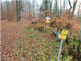 17
17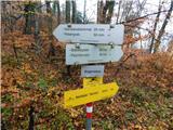 18
18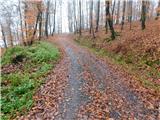 19
19 20
20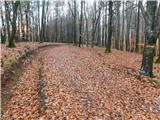 21
21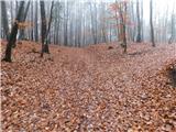 22
22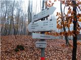 23
23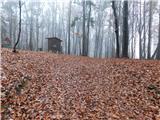 24
24 25
25
Discussion about the trip Pichla bei Radkersburg - Königsberg
To post a comment you must log in:
If you do not yet have a username, you must first
register.