Planina Zajzera - Cima Vildiver (Due Pizzi)
Starting point: Planina Zajzera (1004 m)
Starting point Lat/Lon: 46.4565°N 13.46924°E 
Time of walking: 3 h 15 min
Difficulty: very difficult marked way, easy unmarked way
Difficulty of skiing: no data
Altitude difference: 1004 m
Altitude difference (by path): 1004 m
Map: Julijske Alpe - zahodni del 1:50.000
Access to starting point:
From Kranjska Gora over the border crossing Rateče we drive to Trbiž / Tarvisio. Further, we drive on the old road towards Videm / Udine. Already after few kilometers from Trbiž / Tarvisio, the road into Ovčja vas / Valbruna branches off to the left. Here we turn left and we follow the road all the way to the mountain pasture Zajzera, where we park on a large parking lot.
Path description:
From the parking lot from where there is a very nice view towards the northern wall of Montaž we go on the path 611 on the right side of the chapel. We follow the signs for mountain hut Rifugio Grego and already at the beginning we start relatively steeply ascending through the forest, and later we also few times cross a macadam road which also leads towards the mountain hut Rifugio Grego. After that, the path turns slightly to the right and it brings us on a forested ridge from which a view opens up a little on the northern side. For a better view, we need to step on some of panoramic points on the edge of the ridge and in doing so some caution is needed because the ridge is precipitous on the northern side.
Further, we are still ascending through the forest and occasionally beautiful views opening up towards Montaž and Viš. Such a path we then follow all the way to the mountain hut Rifugio Grego where there is a breathtaking view mainly towards Montaž.
From the mountain hut, we descend a little on a macadam road to a saddle Rudni vrh (Sella di Somdogna) on which runs also an asphalt road from the valley Dunjska dolina. We continue on the asphalt road on which we descend few turns, and then we leave the road and go right on a narrow marked footpath.
The path then mostly steeply ascends through dwarf pines and crosses a few torrents. Such a path we follow all the way to a marked crossing where the path branches off to the right to Pipar (2069 meters).
We continue left on path 468 toward bivouac Bernardinis. From the crossing, the path slightly descends, then follows a crossing of steeper slopes. The path here becomes more demanding, and some fixed safety gear is available for assistance. Due to the slippery sand on the path, considerable caution is needed in some spots. After that, the path becomes less demanding, and from the left, path 605 joins, which also comes from valley Dunjska dolina, but with a slightly lower starting point. The path turns a little to the right and starts ascending towards the notch Forcella Cianalot (1830m).
At the notch where a marked crossing is located, we turn left toward bivouac Bernardinis. From the crossing, the path ascends a slope covered with dwarf pines. Higher up, the dwarf pines become sparser, and the path leads us to more grassy terrain. Only a short ascent remains to bivouac Bernardinis.
From the bivouac, we continue on path 649 and ascend a partly grassy slope above the bivouac. After a short ascent, we come to an unmarked crossing.
We turn left onto an unmarked footpath that leads towards the summit of Cima Vildiver. After a few minutes of steep ascent, we reach the panoramic peak with a cross.
The description and pictures from the crossing for Visoki Pipar to the summit refer to the condition in September 2023. Other pictures are older.
Pictures:
 1
1 2
2 3
3 4
4 5
5 6
6 7
7 8
8 9
9 10
10 11
11 12
12 13
13 14
14 15
15 16
16 17
17 18
18 19
19 20
20 21
21 22
22 23
23 24
24 25
25 26
26 27
27 28
28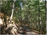 29
29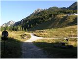 30
30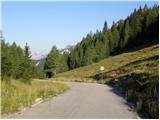 31
31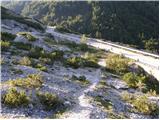 32
32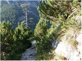 33
33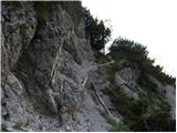 34
34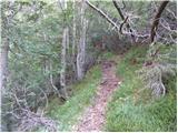 35
35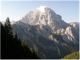 36
36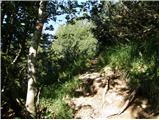 37
37 38
38 39
39 40
40 41
41 42
42 43
43 44
44 45
45 46
46 47
47 48
48 49
49 50
50 51
51 52
52 53
53 54
54 55
55 56
56 57
57 58
58 59
59 60
60 61
61 62
62 63
63 64
64 65
65 66
66 67
67 68
68 69
69 70
70 71
71 72
72 73
73 74
74 75
75 76
76 77
77