Podgorje ob Sevnični (Kurja vas) - Koprivnik (Bohor)
Starting point: Podgorje ob Sevnični (Kurja vas) (349 m)
Starting point Lat/Lon: 46.0598°N 15.36108°E 
Time of walking: 3 h 15 min
Difficulty: easy marked way
Difficulty of skiing: no data
Altitude difference: 635 m
Altitude difference (by path): 785 m
Map:
Access to starting point:
A) We drive to Sevnica (to here from Radeče, Mokronog or Krško), and then we go on the road in the direction of Planina pri Sevnici. When we arrive at the settlement Podgorje ob Sevnični, the described path begins by the bus stop in the hamlet Kurja vas. At the starting point, there aren't any parking spots.
B) We drive to Šentjur (to here from Celje, Štajerska highway exit Dramlje or Šmarje pri Jelšah), and then we follow the signs for Kozje and Planina pri Sevnici. At the end of Šentjur we go right in the direction of Planina pri Sevnici (slightly left - Kozje and Podsreda). Further, we mostly ascend, and when the road flattens and we notice the Petrol gas station on the right side, located in close proximity to Planina pri Sevnici, we gradually start descending towards Sevnica. When we arrive at the settlement Podgorje ob Sevnični, the described path begins by the bus stop in the hamlet Kurja vas. At the starting point, there aren't any parking spots.
Path description:
From the starting point, we take the path toward Zabukovje and the cottage Koča na Bohorju, initially passing a few houses, then crossing the stream Sevnična over a bridge. On the other side of the bridge, the road enters a forest and begins to noticeably ascend. A few minutes later, we leave the forest and continue ascending along its edge to a newer house, which we pass on the right and bypass on the left side. Behind the house, the asphalt ends, and the path continues along a cart track that ascends through the forest. Higher up, blazes redirect us from the cart track to a footpath, along which we ascend moderately at first, then more steeply. When we leave the forest a little higher, the path flattens and leads us past a cemetery to an asphalt road in the settlement Zabukovje nad Sevnico.
Here, we turn left toward Skalice, Planina pri Sevnici, and the cottage Koča na Bohorju (right leads to Sevnica and Ajdovski Gradec). After a minute of further walking, we reach the church of St. Lenart.
A little beyond the church, the road splits, and we choose the slightly right road, marked with signs for Mrzla Planina (slightly left leads to Sevnica). Next follows a moderate ascent with occasional beautiful views of Skalica and other peaks, leading us to the settlement Pokojnik, where we turn right at the crossroads by a chapel (left leads to a serpent-shaped spruce).
This is followed by a short descent, then a diagonal ascent to the right. Looking back, a beautiful view opens up of Zabukovje nad Sevnico and a few other villages. When the settlement Pokojnik ends, at the crossroads by a road mirror, we continue sharply left toward Skalice and the cottage Koča na Bohorju (straight leads to Pokojni Vrh). After the next turn, we approach a homestead, before which we turn left onto a macadam road, where the blazes continue. Higher up, we encounter several turn-offs, where we follow the blazes. Meanwhile, the path turns into a cart track, leading us to a scenic grassy slope, from which a beautiful view opens up, stretching from Snežnik to Peca. The cart track higher up becomes a grassy path. Just a few steps before the summit of Zaloška gora, the marked path turns left and re-enters the forest. Through the forest, we descend diagonally, and when the path flattens, we quickly reach a marked crossroads.
From the crossroads, we turn right toward Veliki Javornik and the cottage Koča na Bohorju (left leads to Skalica and Planina pri Sevnici). Soon, we reach a cross with signs for Bohor. We still continue on a marked path, and at more frequent crossings we carefully follow the blazes. Further, the cart track widens into a macadam road, on which we get to a crossroad on the saddle between Mali and Veliki Javornik.
Here we go right and then immediately left and we are lightly descending on the road. When the road turns right, we leave it and we continue straight on a cart track in the direction of Javornik (right - partisan hospital and Koča na Bohorju - path via Travni laz).
On the cart track, we are mostly ascending diagonally through the forest, and few minutes ahead the path splits.
We continue left steeply upwards towards Veliki Javornik (straight - Koča na Bohorju - path which bypasses Veliki Javornik). Next follows few minutes of a quite steep ascent, and when we leave the forest we go right and on a gently sloping path which runs on the upper grassy slope we quickly get to the highest peak of Bohor - 1023 meters high Veliki Javornik.
From Veliki Javornik we continue straight in the direction of Koprivnik and Koča na Bohorju and we start descending through the forest. Lower, from the right joins also the path which bypasses the peak of Veliki Javornik and is a little shorter, and we continue in the direction of Koča na Bohorju and few minutes ahead we reach the turning point of the forest road. The road in few minutes brings us to the saddle between Veliki Javornik and Koprivnik, where we reach a wider macadam road, where from the left joins also the shorter path from Planina pri Sevnici or Stara Žaga.
Here we go right towards Koča na Bohorju and Koprivnik, and after few steps, we go from the road left towards Koprivnik. From the spot, when we leave the road we start ascending through the forest and in few minutes we reach the peak of Koprivnik.
The starting point - Zabukovje 0:40, Zabukovje - Zaloška gora 1:15, Zaloška gora - Veliki Javornik 0:45, Veliki Javornik - Koprivnik 0:35.
Description and pictures refer to the condition in March 2022 and March 2025.
Pictures:
 1
1 2
2 3
3 4
4 5
5 6
6 7
7 8
8 9
9 10
10 11
11 12
12 13
13 14
14 15
15 16
16 17
17 18
18 19
19 20
20 21
21 22
22 23
23 24
24 25
25 26
26 27
27 28
28 29
29 30
30 31
31 32
32 33
33 34
34 35
35 36
36 37
37 38
38 39
39 40
40 41
41 42
42 43
43 44
44 45
45 46
46 47
47 48
48 49
49 50
50 51
51 52
52 53
53 54
54 55
55 56
56 57
57 58
58 59
59 60
60 61
61 62
62 63
63 64
64 65
65 66
66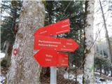 67
67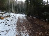 68
68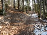 69
69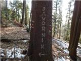 70
70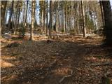 71
71 72
72 73
73 74
74 75
75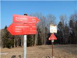 76
76 77
77 78
78 79
79 80
80 81
81 82
82 83
83 84
84 85
85 86
86 87
87 88
88 89
89 90
90 91
91 92
92 93
93