Starting point: Prebold (281 m)
Starting point Lat/Lon: 46.23663°N 15.09309°E 
Time of walking: 1 h 45 min
Difficulty: easy marked way
Difficulty of skiing: no data
Altitude difference: 553 m
Altitude difference (by path): 565 m
Map: Posavsko hribovje - zahodni del 1:50.000
Access to starting point:
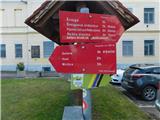
We leave Štajerska highway at the Šentrupert exit, and then we follow the signs for Prebold. In the center of Prebold, at the red hiking signposts, the described path begins, and we park at one of the parking lots in the center of the settlement, by the kindergarten, the primary school, or the cemetery.
Path description:
From the center of Prebold we follow the signs for Mrzlica, Golava, and Hom and initially walk on the sidewalk along road Reška cesta, where blazes soon direct us right onto the street Skozi Gaj, passing a few more houses, and at the edge of a meadow, the path splits again.
We continue left towards Golava and Mrzlica (straight for Žvajga and the Dom na Reški planini via Žvajga) and quickly reach the road leading to Podmeja and Trbovlje, continuing along the sidewalk by the road. A few minutes ahead, we go left from a marked crossing in the direction of Golava and Mrzlica, and on a side road we first descend slightly, then, after passing a few houses, we cross onto a slope over which we start ascending on an initially asphalt road. When the road becomes a macadam, a nice view opens up on Prebold and its surroundings; at the Razpotnik farm, the road ends, and we continue sharply right on a cart track, which then ascends diagonally to the right. A few minutes ahead, below Burkeljčev hrib, we reach another asphalt road, which we follow to the right, and soon after, we turn right onto a parallel mountain path. Just a little further, we cross the road again, then follow a short ascent on a forest path. Higher up, we leave the forest, pass by a nearby house, then cross an asphalt road, and we are already at the Lovski dom pod Golavo.
We bypass the hunting lodge on the right side and head onto the path in the direction of Golava and Mrzlica. The path ahead first leads along a cart track, then for a short time on a slightly steeper footpath, which quickly joins another cart track that we follow to the right. Next follows a gentle diagonal ascent; when we reach the northeastern ridge of Golava, we arrive at a marked crossing, from which we continue right in the direction of Golava (left downwards Hom, Kamnik, and Matke, straight Mrzlica).
The path ahead ascends more steeply along the northeastern ridge of Golava, and when the path and ridge flatten out slightly, we arrive at the vantage point Gradišče (inscription on the rock).
After the vantage point, the path returns to the forest and, in a few minutes of further walking, leads us to the peak of Golava, where the Blažev bivouac is located.
Prebold - Lovski dom 1:00, Lovski dom - Golava 0:45.
Pictures:
 1
1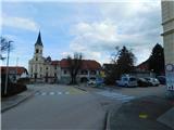 2
2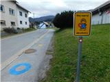 3
3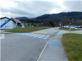 4
4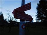 5
5 6
6 7
7 8
8 9
9 10
10 11
11 12
12 13
13 14
14 15
15 16
16 17
17 18
18 19
19 20
20 21
21 22
22 23
23 24
24 25
25 26
26 27
27 28
28 29
29 30
30 31
31 32
32 33
33 34
34 35
35 36
36 37
37 38
38 39
39 40
40 41
41 42
42 43
43 44
44 45
45