Prebold - Homič (via Kriška planina)
Starting point: Prebold (281 m)
Starting point Lat/Lon: 46.23663°N 15.09309°E 
Path name: via Kriška planina
Time of walking: 3 h 5 min
Difficulty: easy marked way
Difficulty of skiing: no data
Altitude difference: 801 m
Altitude difference (by path): 860 m
Map: Posavsko hribovje - zahodni del 1:50.000
Access to starting point:
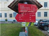
We leave Štajerska highway at the Šentrupert exit, and then we follow the signs for Prebold. In the center of Prebold, at the red hiking signposts, the described path begins, and we park at one of the parking lots in the center of the settlement, by the kindergarten, the primary school, or the cemetery.
Path description:
From the center of Prebold we follow the signs for Mrzlica, Golava, and Hom and initially walk on the sidewalk along road Reška cesta, where blazes soon direct us right onto the street Skozi Gaj, passing a few more houses, and at the edge of a meadow, the path splits again.
We continue left towards Golava and Mrzlica (straight for Žvajga and the Dom na Reški planini via Žvajga) and quickly reach the road leading to Podmeja and Trbovlje, continuing along the sidewalk by the road. A few minutes ahead, we go left from a marked crossing in the direction of Golava and Mrzlica, and on a side road we first descend slightly, then, after passing a few houses, we cross onto a slope over which we start ascending on an initially asphalt road. When the road becomes a macadam, a nice view opens up on Prebold and its surroundings; at the Razpotnik farm, the road ends, and we continue sharply right on a cart track, which then ascends diagonally to the right. A few minutes ahead, below Burkeljčev hrib, we reach another asphalt road, which we follow to the right, and soon after, we turn right onto a parallel mountain path. Just a little further, we cross the road again, then follow a short ascent on a forest path. Higher up, we leave the forest, pass by a nearby house, then cross an asphalt road, and we are already at the Lovski dom pod Golavo.
We bypass the hunting lodge on the right side and head onto the path in the direction of Golava and Mrzlica. The path ahead first leads along a cart track, then for a short time on a slightly steeper footpath, which quickly joins another cart track that we follow to the right. Next follows a gentle diagonal ascent, and when we reach the northeastern ridge of Golava, we arrive at a marked crossing, from which we continue straight in the direction of Mrzlica (left downwards Hom, Kamnik, and Matke, right Golava and Mrzlica via Golava).
Next follows a gentle diagonal descent, and then we reach the meadow Na Goljavi, where we bypass on the right side the homestead "Pri Golavski Micki". The path ahead leads us along a macadam road, and when we reach the indistinct southern ridge of Golava, the path Andrejeva pot to Golava (sometimes called path Ovčja pot) branches off to the right.
We continue along the road, and a little lower, paths from Marija Reka join from the right, namely from the starting points at Strgarjev kamnolom quarry and Koritnikov most bridge, but we continue left in the direction of Mrzlica and descend slightly further along the road.
At the Kočet homestead, we reach the saddle between Golava and Homič, where we turn right (straight leads to Mrzlica along and by the ridge of Homič), and we walk along the road to the Zgornji Dolinar homestead, where signs for Mrzlica direct us left onto a path that ascends above the road.
Here we diagonally ascend through a scenic meadow, from which a beautiful view of Golava opens up, and then the path enters the forest and, after a short crossing, brings us to a forest road, which we follow upwards, passing a small spring, and continue to its end, where a marked crossing is located by a turning point.
From the crossing, we continue straight (left Mrzlica on the forest logging trail) in the direction of Mrzlica over Kriška planina (on maps we notice Kriška planina, but on the hiking signposts Križka planina) and at first, we continue on a cart track which initially ascends diagonally towards the right, and higher up towards the left. Next follow a few more crossings, where we follow occasionally sparse blazes, then we turn left from the cart track and ascend through a strip of forest to the lower edge of Kriška planina. An ascent follows across the mountain pasture, where the path leads us along a cart track, and we reach a macadam road which we follow to the left (right Podmeja and Trbovlje). The road we walk on soon enters the forest and leads us to a marked crossing, where a path from the forest logging trail joins from the left.
We don’t walk long along the road, as signs for the Prebold mountain path quickly direct us left onto a footpath leading toward the summit of Homič (straight along the road leads to Mrzlica). The path ahead becomes quite steep and leads us along the forested ridge of Homič, whose summit we reach after approximately ten minutes of ascent from the point where we left the road.
Prebold - hunting lodge 1:00, hunting lodge - Kočet 0:40, Kočet - Homič 1:25.
Description and pictures refer to conditions in April 2025.
Pictures:
 1
1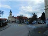 2
2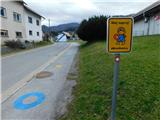 3
3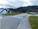 4
4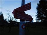 5
5 6
6 7
7 8
8 9
9 10
10 11
11 12
12 13
13 14
14 15
15 16
16 17
17 18
18 19
19 20
20 21
21 22
22 23
23 24
24 25
25 26
26 27
27 28
28 29
29 30
30 31
31 32
32 33
33 34
34 35
35 36
36 37
37 38
38 39
39 40
40 41
41 42
42 43
43 44
44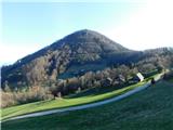 45
45 46
46 47
47 48
48 49
49 50
50 51
51 52
52 53
53 54
54 55
55 56
56 57
57 58
58 59
59 60
60 61
61 62
62 63
63 64
64 65
65 66
66 67
67 68
68 69
69 70
70 71
71