Predmeja (tuneli) - Mala gora (Srednječavenska pot)
Starting point: Predmeja (tuneli) (800 m)
| Latitude/Longitude: | 45,93770°N 13,86920°E |
| |
Route name: Srednječavenska pot
Walking time: 1 h 30 min
Difficulty: partly demanding marked way
Elevation gain: 234 m
Elevation difference along the route: 315 m
Map: Goriška 1:50.000
Recommended equipment (summer): helmet
Recommended equipment (winter): helmet, ice axe, crampons
Views: 47.220
 | 2 people like this post |
Access to starting point:
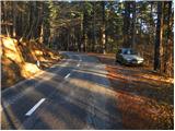
From the highway Razdrto - Nova Gorica, take the Ajdovščina exit and follow the road ahead towards the village Lokavec (to Lokavec we come from the center of Ajdovščina, or from the old road Ajdovščina - Nova Gorica, where at the settlement Cesta we turn right). From Lokavec we continue driving on the ascending winding road in the direction of Predmeja. We follow the mentioned road to the mountain signposts for Čaven, Veliki rob and Kucelj (signposts are located between the quarry and tunnels, road sign approx. 10 km). We park a few tens of meters lower on the parking lot by the road.
To the starting point we can also come from Godovič, via Črni vrh and Col to Predmeja. In this case from Predmeja we descend towards Ajdovščina and then soon after the third tunnel we park.
Route description:
From the parking lot, we first walk to the signposts, then head onto the Srednječavenska pot. The path, which goes immediately into the forest, first moderately ascends and then continues crossing the slopes towards the south. A wide and well-maintained mountain path soon enters steep slopes (danger of falling rocks) and gradually turns more and more towards the right. A little further, beautiful views open up from the path on Nanos and Vipava valley, and the path gradually transitions into more rocky terrain. A little further still, the path again enters dense forest, where it begins to descend gently. After a short gentle descent, we reach a junction, where we continue straight (left down to Lokavec, right up to the Koča na Čavnu hut) along the path which, although it runs at an altitude of approximately 900 m, takes on the appearance of a true high-mountain path. The path leads us from the mostly pine forest onto scree, from which a nice view opens onto the valley, and to the right we see steep rocky cliffs. At the end of the scree, the path enters the ridge of the eastern forepeak of Mala gora, where with the help of steel cables we cross a wide and also partly exposed ledge. At the end of the ledge, a nice view opens up on the Slano blato landslide above Lokavec, and we continue along the Srednječavenska pot, which turns a little more to the right, where it begins to descend slightly through a belt of bushes. After a short descent, the path levels out, and beside it we notice a large rocky ridge and next to it a pleasant bench for a short or longer rest. The path, which then continues through the forest, quickly brings us to the next junction.
This time we continue right in the direction of Mala gora and Čaven (left down to Stomaž, straight ahead the Srednječavenska pot continues) along the path, which begins to ascend more steeply. After a few minutes of steep ascent, the steepness eases and the path brings us to the unvegetated grassy slopes of Mala gora, where we also reach the next junction. Here we continue left (straight up to the Koča na Čavnu hut) along the path which mostly crosses the slopes towards the west. After approximately 10 minutes of walking from the junction, the path descends and brings us in a few steps to the hut on Mala gora.

Photos:
 1
1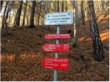 2
2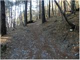 3
3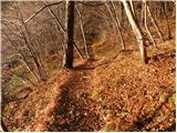 4
4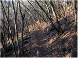 5
5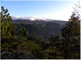 6
6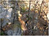 7
7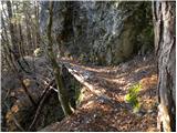 8
8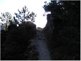 9
9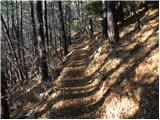 10
10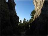 11
11 12
12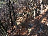 13
13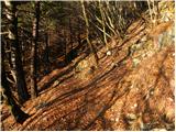 14
14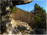 15
15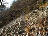 16
16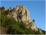 17
17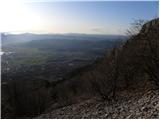 18
18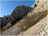 19
19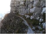 20
20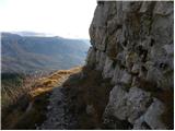 21
21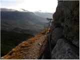 22
22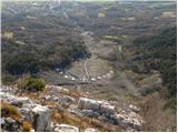 23
23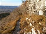 24
24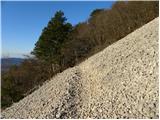 25
25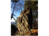 26
26 27
27 28
28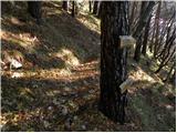 29
29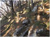 30
30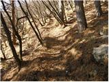 31
31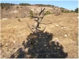 32
32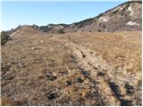 33
33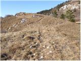 34
34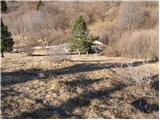 35
35 36
36
Discussion about the trip Predmeja (tuneli) - Mala gora (Srednječavenska pot)
|
| VanSims18. 10. 2010 |
Given that there is no comment here and I met no one on the path, it seems this path is not that popular. Pity, because it is nice and interesting.
Don't let the 'partly demanding' label mislead you, which probably refers to the otherwise exposed but very wide and secured ledge. Even that protection is more psychological support or protection against sudden bora gusts that I also experienced. 
|
|
|
|
| gvodopivec18. 10. 2010 |
Hello VSims,
I agree with you that the mentioned path is nice and interesting and not too demanding  Worth mentioning is also the nice view of Vipava Valley and all the way to the sea... Worth mentioning is also the nice view of Vipava Valley and all the way to the sea...
I don't know when you visited these "parts", since usually (especially on weekends) you can meet many hikers on this path heading to Mala Gora or Čaven.
Well, if you walk around here again, you're welcome any sunny Sunday for tea at the Kamenjskih planincev hut on Mala Gora
Nice hiking greetings
|
|
|
|
| gvodopivec18. 10. 2010 |
More information about Mala Gora and surrounding excursions can be found at www.kamnje.si
(http://www.kamnje.si/index.php?option=com_content&view=article&id=69&Itemid=71)
Nice regards
|
|
|
|
| pier21. 02. 2011 |
Yesterday we went to Mala gora and further to the hut on Cavnu. Snow on the path just a trace. Pleasant surprise when we found the hut on Mali Gori open. Friendly volunteers served us tea, freshly baked bread and sausage. Temperature -2°C and not too windy. In short, a nice Sunday outing.
|
|
|
|
| Enka21. 02. 2011 |
How long is it from the last junction on this path (on the uncultivated grassy slopes of Mala gora) to the hut at Čavn (if you don't go left, but straight up)?
|
|
|
|
| pier22. 02. 2011 |
approximately 20 - 25 minutes.
Best regards
|
|
|
|
| Enka22. 02. 2011 |
Aha, just right. Thank you very much for the quick information.
|
|
|
|
| Enka10. 03. 2011 |
Two things interest me . Could there be any problem for dogs on the exposed part of this path? And, how large is this parking lot by the road? Could there be a parking issue on the weekend for a few cars around 9am? And where to park in that case? . Could there be any problem for dogs on the exposed part of this path? And, how large is this parking lot by the road? Could there be a parking issue on the weekend for a few cars around 9am? And where to park in that case?
|
|
|
|
| VanSims10. 03. 2011 |
For a dog, exposure shouldn't be a problem if it doesn't fear heights. More of an issue could be scree and rocks. If it's not used to such terrain or lacks suitable footwear (which apparently is available in pet stores).
As for the parking lot, it's not very large (for about 10 cars). I was there on a weekend around 8am and was the only one, but that was around October. I don't know about summer.
Otherwise, you can probably park in Predmeja itself instead of at the tunnels and then walk a short distance along the road to the start (a kilometer or two).
|
|
|
|
| Enka12. 03. 2011 |
Big thanks for all the info! We'll come very soon to check if they hold . .
|
|
|
|
| tine.sl13. 03. 2011 |
100 meters before the start of the Srednječavenska path there is an old sand pit with space for at least 50 vehicles and even a bus. Regarding the dog, no worries, the path is wide enough even for numerous mountain bikers so there won't be a problem.
|
|
|
|
| Enka13. 03. 2011 |
Tine, many thanks, now we'll be calm. Is this sand pit by the main road? From the direction of Col, is it 100m before or after the start of the path?
|
|
|
|
| Enka13. 03. 2011 |
Read the path description again and realized that the quarry from the Col direction is 100m after the sign for the start of the path.
|
|
|
|
| Enka4. 04. 2011 |
Beautiful trail, interesting and varied, beautiful views, intoxicating scent of pines. Exposed sections are less exposed than they appear in the photos, so go ahead boldly, it's worth it!
|
|
|
|
| ben30. 04. 2012 |
Hello, does anyone perhaps know if there is any driving ban for buses from the direction of Ajdovščina via Lokavec to this quarry before the tunnels? Thanks for the information
Best, B
|
|
|
|
| klemen7326. 07. 2012 |
path almost flat, just suitable to test new hiking boots.

Obviously someone who went on this path in previous days "made an effort" to scatter fresh broken twigs and branches on the trail, which got between our legs and hindered normal walking. I removed most anyway.
We continued the tour towards Mala gora and on to the hut on Čavnu (here we had to push a bit uphill already  )and down the steep path to the start. )and down the steep path to the start.
Space on Mala gora really idyllic.
Weather ideal for such a tour.
Tour worth repeating (by going from the hut towards Kuclje and further to Krnica).
|
|
|
|
| gvodopivec27. 07. 2012 |
The tour is worth repeating, but on a Sunday when there will also be one of the duty mountaineers in the hut on M. gora
The twigs were probably scattered by the "Vipavska burja"
Nice mountaineering greeting
|
|
|
|
| klemen7318. 08. 2012 |
@gvodopivec
bora doesn't cut branches with a knife, does it?
|
|
|
|
| balon15. 08. 2013 |
how passable is the road to the starting point?
|
|
|
|
| ajax15. 08. 2013 |
excellent
|
|
|
|
| balon15. 08. 2013 |
I have one more question. Is the path "under" the overhang secured?
Thanks
|
|
|
|
| ajax15. 08. 2013 |
Yes
|
|
|
|
| balon15. 08. 2013 |
fine thanks ajax
|
|
|
|
| balon17. 08. 2013 |
yesterday I was up there. The trail is well marked, only at the Čaven-Kucelj junction there could be a sign for the hut on Mala gora on the board. In terms of "difficulty" they could remove the "partly demanding" sign and write easy trail.
In short, the trail is great for introducing children to hiking.
Best regards,
Balon
|
|
|
|
| Acibujl14. 02. 2026 17:14:12 |
For me, one of the most beautiful trails in our karst highlands. I park at the tunnels, for a welcome warm-up the path doesn't climb for a while, it just crosses the slopes. I ascend to the pleasant small hut on Mala gora, where they even have a schnapps vending machine, from there I continue to Kucelj. It offers wide views! I could go further, but today I don't feel like it on the descent from Kuclja at the junction I turn towards the A. Bavčar hut on Čavnu. There I descend back towards the transverse Srednječavenska into the valley back. Wonderful loop, the bora doesn't blow over it I recommend it, as you can make it as long as you like!
|
|
|
|
| Acibujl14. 02. 2026 17:21:02 |
For me, one of the most beautiful trails in our karst highlands. I park at the tunnels, for a welcome warm-up the path doesn't climb for a while, it just crosses the slopes. I ascend to the pleasant small hut on Mala gora, where they even have a schnapps vending machine, from there I continue to Kucelj. It offers wide views! I could go further, but today I don't feel like it on the descent from Kuclja at the junction I turn towards the A. Bavčar hut on Čavnu. There I descend back towards the transverse Srednječavenska into the valley back. Wonderful loop, the bora doesn't blow over it I recommend it, as you can make it as long as you like! But if at the hut on Mala gora you turn right to the hillock, there wind paths to those interesting rock formations that everyone photographs so much. Along the path there are side branches, and they are all nicely marked! And there you decide whether to turn back up the hill to the hut on Čavnu or directly to the valley... The smarter variant is first to Čavnu, continue to Kucelj, descend to Mala gora and past the rock formations back to the valley
|
|
|
To post a comment you must log in:
If you do not yet have a username, you must first
register.