Starting point: Radeče (198 m)
Starting point Lat/Lon: 46.06636°N 15.18189°E 
Time of walking: 2 h 45 min
Difficulty: easy marked way
Difficulty of skiing: no data
Altitude difference: 760 m
Altitude difference (by path): 820 m
Map:
Access to starting point:
From the road Zidani Most - Sevnica, after the bridge over the river Sava, we turn right into Radeče (from the direction of Sevnica, we turn left before the bridge) and then park at one of the parking lots in the town center.
Path description:
From the parking lot, we walk to square, where Plečnik's NOB monument stands, then proceed along the path toward Kum, Nebeška gora, and Svinjski rt. The path continues along street Starograjska ulica, which we leave at the parish church of St. Peter, turning left and ascending the stairs for a while. A little further, we reach a narrower asphalt road, which we follow past the last houses, then continue on a cart track that ascends diagonally. The path soon enters the forest, but before reaching it, a view of part of Radeče opens up when looking back. In the forest, the path turns left and ascends diagonally to a ridge, where we notice the ruins of an old castle sharply to the right, but we continue straight and soon leave the forest. We proceed along a well-maintained path through bushes, then reach a road, which we follow briefly to the right before taking a footpath that crosses the road twice more higher up, then stay on the road, following the blazes or signs for Kum at crossroads. Higher up, the road becomes macadam and ascends diagonally to a saddle between Vranski hrib on the left and Svinjski rt on the right.
We continue slightly left (to the right, behind the chapel, Svinjski rt, five minutes) along the macadam road, which first crosses the slopes of Vranski vrh, then gradually moves away from the hill, passing a few houses to reach an asphalt road, which we follow to the right uphill (continuing downhill leads to the gnomes in the settlement Jelovo). When the hamlet ends, the road returns to the forest and splits.
We continue straight toward Kum and Nebeška gora (to the right, an unmarked road leads to the church of St. Katarina, 10 minutes), and shortly after, we cross a high-voltage power line route, where a nice view briefly opens up. A little further, from a small crossroad, we continue slightly to the right; the road higher up makes two more hairpin turns, and we cross the power line route twice more. The road then flattens and leads past individual farms, where we stick to the main road or follow the blazes. For a while, the path offers beautiful views extending to the left bank of the Sava River, where we see Kopitnik and Gore, before the road returns to the forest and begins to visibly descend. After a few minutes of descent, we reach a small valley with a road crossroad, where we keep to the rightmost road, following the blazes. The path leads through the forest again, and when the road turns right, we leave it, continuing left on a footpath that follows an indistinct small valley. The path ahead is often overgrown, but higher up, it ascends to the right from the small valley, quickly reaching a cart track, which we follow to the left. We continue ascending, soon leaving the forest and returning to an asphalt road, which we follow to the right. The road then flattens and splits just before the settlement Čimerno.
We continue slightly to the right, where a marked path from Zagrad or the Sopota valley joins from the left shortly after.
Here, we continue straight and quickly reach the church of the Holy Trinity, located in the settlement Čimerno.
We proceed along the asphalt road, which soon splits.
From the road, we go slightly left onto a cart track in the direction of Nebeška gora (continuing along the road Kum), where at a few smaller crossings we follow the blazes. A little further in the forest, we turn left from a wider cart track onto a narrower cart track, which soon becomes a footpath. Higher up, we reach a turn-off to the viewpoint, which is less than a minute’s walk away, but the path to the viewpoint in the last few steps, especially in wet conditions, is somewhat exposed to slipping. From the crossing, the final ascent follows, and we reach the summit of Nebeška gora, where the wish bell is located.
Radeče - old castle 0:10, old castle - Čimerno 2:05.
Description and pictures refer to the condition in May 2024.
Pictures:
 1
1 2
2 3
3 4
4 5
5 6
6 7
7 8
8 9
9 10
10 11
11 12
12 13
13 14
14 15
15 16
16 17
17 18
18 19
19 20
20 21
21 22
22 23
23 24
24 25
25 26
26 27
27 28
28 29
29 30
30 31
31 32
32 33
33 34
34 35
35 36
36 37
37 38
38 39
39 40
40 41
41 42
42 43
43 44
44 45
45 46
46 47
47 48
48 49
49 50
50 51
51 52
52 53
53 54
54 55
55 56
56 57
57 58
58 59
59 60
60 61
61 62
62 63
63 64
64 65
65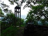 66
66