Ruška koča na Arehu - Mali Šumik waterfall
Starting point: Ruška koča na Arehu (1246 m)
Starting point Lat/Lon: 46.4956°N 15.5077°E 
Time of walking: 2 h 15 min
Difficulty: difficult marked way
Difficulty of skiing: no data
Altitude difference: -356 m
Altitude difference (by path): 100 m
Map: Pohorje 1:50.000
Access to starting point:
A) From the Ljubljana - Maribor highway, take the Rače - Fram exit, then follow the signs for Fram. Continue through the center of Fram, then begin ascending towards the settlements of Kopivnik, Planica and Frajhajm; higher up, follow the signs for Areh. When joining a wider road, go left and continue following the signs for Areh. Park on the large parking lot near Ruška koča na Arehu.
B) Leave the Štajerska highway at the exit for Slivnica and Rogoza, then follow the signs for Pohorje and Areh. The route ahead leads through Spodnje and Zgornje Hoče, Slivniško Pohorje; after the settlements, follow the signs for Areh. Park on the large parking lot near Ruška koča na Arehu.
Path description:
From the parking lot near Ruška koča na Arehu, head onto the road towards Žigartov vrh, Šumik and Cojzarice. After about 10 minutes of walking along the road through the forest, arrive at a marked junction, where continue left towards Bajgot and Šumik waterfall (straight to Žigartov vrh).
The path ahead returns to the forest and leads along a poorer forest road, from which soon a path branches off to the left downward to the source of Polskava (5 minutes); we continue straight. After some time, go slightly right from the poorer road onto a cart track that ascends transversely up the slopes of Žigartov vrh. The cart track quickly levels out and brings us to a marked junction, where a path joins from the right leading over Žigartov vrh and somewhat longer than ours.
Continue straight and gradually descend through the forest; lower, cross another forest road. Further on, mostly walk on cart tracks along the path that rises and falls several times; at junctions, follow the blazes. After a somewhat longer descent, arrive at the NOB monument, where reach the macadam road.
Along the road, walk only a few dozen steps and the path forks.
Choose the right path towards Pesek (left to sv. Trije kralji) and temporarily leave the road; a little further, cross another road, continue straight along the poorer forest road accompanied by blazes. Follows some slight ascent, then pass the hunting observation post; the road gradually changes into a cart track. A little further, go slightly right from the cart track, then begin descending transversely. Lower, cross the road Areh - Osankarica; a bit lower still, reach the road Areh - Šumik.
When reaching the road Areh - Šumik, go left; from the left also joins a marked path from sv. Trije kralji and Osankarica. Continue further along the road, quickly arriving at the starting point Bajgot na Šumiku, where one of the paths to Ruše branches right downward (Holcarska pot through the Lobnica valley).
Continue in the mentioned direction, along which there are also signs for Mali and Veliki Šumik waterfalls (straight to Šumik estate, Koča na Klopnem vrhu...).
The path ahead begins gently descending along Lobnica; soon arrive at a warning that the path ahead is very steep and slippery. A little further, cross Lobnica over a footbridge, then descend along its right bank, gradually transitioning to steeper slopes. Further on, at difficult spots, pegs and steel cables assist; a bit lower, using safety gear, descend over a short wall. Even below the wall, the slope is quite steep and slippery; descend mainly without protections.
A bit lower still, arrive at the spot with the stamp, then descend the secured path to the viewpoint on Veliki Šumik waterfall.
From Veliki Šumik, continue on the path still descending along Lobnica over partly steep slopes. A little further, using a steel cable, cross Verna stream, which at high water turns into several smaller waterfalls. Just a little further, cross Lobnica river over a small bridge. Immediately after the bridge, notice signs for the 9 m high waterfall.
From the sign, see the waterfall from above; to see it from below, continue on the path that first ascends then descends to a junction. Here, continue right downward on the steep path, quickly reaching the Lobnica riverbed, from which a view opens onto Mali Šumik waterfall.
Ruška koča na Arehu - Veliki Šumik waterfall 2:00, Veliki Šumik waterfall - Mali Šumik waterfall 0:15.
Pictures:
 1
1 2
2 3
3 4
4 5
5 6
6 7
7 8
8 9
9 10
10 11
11 12
12 13
13 14
14 15
15 16
16 17
17 18
18 19
19 20
20 21
21 22
22 23
23 24
24 25
25 26
26 27
27 28
28 29
29 30
30 31
31 32
32 33
33 34
34 35
35 36
36 37
37 38
38 39
39 40
40 41
41 42
42 43
43 44
44 45
45 46
46 47
47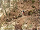 48
48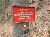 49
49 50
50 51
51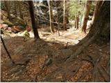 52
52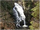 53
53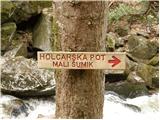 54
54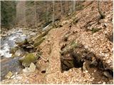 55
55 56
56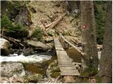 57
57 58
58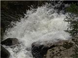 59
59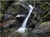 60
60