Solbica / Stolvizza - Sart / Žrd (via Ricovero Igor Crasso)
Starting point: Solbica / Stolvizza (553 m)
Starting point Lat/Lon: 46.36075°N 13.35404°E 
Path name: via Ricovero Igor Crasso
Time of walking: 6 h
Difficulty: difficult marked way
Difficulty of skiing: no data
Altitude difference: 1771 m
Altitude difference (by path): 1820 m
Map: Tabacco 27
Access to starting point:
Over the border crossing in Rateče we drive through Trbiž / Tarvisio. If we drive on the highway, we leave it at the exit for Tablja / Pontebba. We continue driving on the old road in the direction of Videm / Udine. In the settlement Na Bili / Resiutta we turn left towards the valley of Rezija (Val Resia). Further, we drive on a narrower asphalt road and follow the signs for the settlement Solbica / Stolvizza. In the settlement Solbica, we drive along a narrow road through the village center, then notice a larger asphalt parking lot on the right side where we can park.
Access is also possible on a narrow and winding road through the border crossing Učja.
Path description:
From the parking lot in the village Solbica we continue on the main road which quickly brings us to a crossroad where the road branches off to the right towards the village Korito. We continue straight in the direction of the village Ladina. After a few turns we reach the mentioned village and then a crossroad where we will also notice signposts.
We continue on the left road (Via Rastje) where the signs for the bivouac Ricovero Crasso also point us. From the crossroad the road ascends a bit more steeply and soon the signs for the paths Pusti Gost and Vertical Kilometer direct us to the left. Here we bypass the last houses in the village, and then the road turns right into the forest. We then continue ascending in zig-zags on a narrow and steep road through the forest. The asphalt soon ends and the road transitions into a cart track, and a little higher into a footpath. We continue ascending in zig-zags through the forest and soon a path branches off to the right past military trenches from the First World War. The marked path here turns to the left, and a few turns higher the paths rejoin. The path then soon leads us out of the forest onto the mountain pasture Tuurse where there is also a private house. On the mountain pasture, an unmarked path from the village Solbica joins us from the left. We continue right on the path 643 and the path briefly continues across the mountain pasture where we will notice a few more ruins. The path then turns to the left and brings us back into the forest. Further, the path mostly ascends, crossing occasionally very steep slopes, and then brings us to a small saddle on the northern side of the peak Tanarado. Here there is also a crossing where the path Ta Na Rado runs to the left. We continue right and quickly reach another crossing where the path Vertical Kilometer joins from the left. We continue on the marked path through the forest, from which a view occasionally opens up. Soon the path Pusti Gost branches off to the left, but we continue straight on the path 643, where the path Vertical Kilometer also runs. The path soon brings us to the mountain pasture Lommig where we will again notice some ruins. We continue through a strip of forest, and then the path leads us past a cottage on the nearby mountain pasture.
The path then brings us back into the forest and turns slightly to the left. We then continue ascending through the forest for some time, with beautiful views opening up from the path, mainly towards the south. The path ascends diagonally here, and the forest becomes somewhat thinner. Such a path then brings us to the marked crossing.
We continue right on the path 632 towards the bivouac Ricovero Crasso, and after a few dozen meters, an unmarked path branches off to the left, running slightly more to the west and rejoining us higher up. We continue straight, ascending on an increasingly panoramic path. A short footpath to drinking water branches off to the right, but we continue ascending among increasingly sparse trees. As we approach the ridge, from where a view opens up to the northern side into the valley Reklanska dolina and towards Strma peč, the mentioned unmarked path joins us from the left. We continue right, and the panoramic path soon brings us to the well-maintained bivouac Ricovero Igor Crasso.
At the bivouac, we continue right on the marked path, which soon slightly descends to the saddle Buja / Sella Buia, where there is also a marked crossing. A less worn path from the village Pezzeit joins us from the left here.
From the crossing, we continue straight and cross the steeper slopes below the summit Picco di Mezzodi. We continue crossing the slopes towards the east and southeast for quite some time, and occasionally some caution is needed as the slope is quite steep. The path also leads us past a memorial with a cross and a logbook, and during the crossing, it ascends slightly. This path then brings us to the less steep grassy slopes on the southern side of Žrd (Monte Sart). The path soon leads us to a somewhat less visible crossing.
Here we leave the better-trodden path and turn left towards the summit Žrd, where an arrow on a rock points us. From the crossing, we ascend a mostly grassy slope towards the summit Žrd, which is marked with red triangles, though the footpath here is mostly not visible. During the ascent, we consistently follow the red triangles and climb an occasionally steeper slope, requiring considerable caution, especially in wet conditions. On such a slope, we continue all the way to the top, which we reach from the southwestern side.
If we wished to ascend to the summit via a more frequented and well-trodden path, we could, at the aforementioned poorly visible crossing on the southern side of Žrd, continue straight to Škrbina v Senožečah (Forchia di Terra Rossa) and ascend to the summit along the eastern ridge, where the path is somewhat better trodden. The path along the eastern ridge to the mentioned saddle is also recommended for the descent. From the notch, we can continue westward and descend along the ascent route or proceed eastward to the bivouac Marussich and from there descend along path 634 towards the village Solbica (Stolvizza).
Description and pictures refer to conditions in August 2024.
Pictures:
 1
1 2
2 3
3 4
4 5
5 6
6 7
7 8
8 9
9 10
10 11
11 12
12 13
13 14
14 15
15 16
16 17
17 18
18 19
19 20
20 21
21 22
22 23
23 24
24 25
25 26
26 27
27 28
28 29
29 30
30 31
31 32
32 33
33 34
34 35
35 36
36 37
37 38
38 39
39 40
40 41
41 42
42 43
43 44
44 45
45 46
46 47
47 48
48 49
49 50
50 51
51 52
52 53
53 54
54 55
55 56
56 57
57 58
58 59
59 60
60 61
61 62
62 63
63 64
64 65
65 66
66 67
67 68
68 69
69 70
70 71
71 72
72 73
73 74
74 75
75 76
76 77
77 78
78 79
79 80
80 81
81 82
82 83
83 84
84 85
85 86
86 87
87 88
88 89
89 90
90 91
91 92
92 93
93 94
94 95
95 96
96 97
97 98
98 99
99 100
100 101
101 102
102 103
103 104
104 105
105 106
106 107
107 108
108 109
109 110
110 111
111 112
112 113
113 114
114 115
115 116
116 117
117 118
118 119
119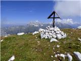 120
120