Spodnje Radvanje - Ruška koča na Arehu (southern path)
Starting point: Spodnje Radvanje (279 m)
Starting point Lat/Lon: 46.53234°N 15.62835°E 
Path name: southern path
Time of walking: 4 h 5 min
Difficulty: easy marked way
Difficulty of skiing: no data
Altitude difference: 967 m
Altitude difference (by path): 1065 m
Map: Pohorje 1:50.000
Access to starting point:
We drive to Maribor, more precisely on road Tržaška cesta, where at the industrial zone or shopping centers at the traffic light intersection we turn toward the settlement Razvanje. Further, we drive on road Papeževa cesta, then turn right toward Pohorje (left for Razvanje). When we reach the next intersection a little further, we continue "straight" (second exit), then at the following roundabout we turn "left" (third exit) and park a few tens of meters further in the parking lot in front of the information board at the start of the Slovenian mountain trail.
Path description:
From the parking lot, we continue on the street Pot na okope, and behind the houses, the road passes into the forest, where it splits into a few cart tracks. We continue on the slightly right cart track, by which the blazes continue, and we start gently ascending on the path that leads us between blackberry bushes and below the route of a high-voltage power line. The path ahead passes into a dense forest and gradually starts ascending steeply, and at a few crossings, we follow the blazes. Higher up, we reach a macadam road, which we follow to the left, and it quickly brings us to an asphalt road, on which we ascend to a marked crossing.
From the crossing, we continue straight on the road (right Sveti Bolfenk and Mariborska koča on SPP), which soon leaves the forest and leads us with beautiful views past a few houses, then we briefly return to the forest. When we leave the forest, the path leads us past the apartments Vilaraj, and after the apartments, from a smaller crossroad, we continue right. Further on, we pass a few more houses, then the path continues through the forest, where we pass only occasional houses. After the traffic sign marking a dead-end street, we choose the lower road, which leads us past a few more holiday cottages, then we continue on a cart track that runs alongside the stream, and soon the cart track turns left and ascends diagonally up the slope. Further on, we encounter several crossings where we follow sparse blazes; higher up, we first reach a macadam road, then an asphalt road, which we follow to the right (straight across the road, a marked footpath continues, but it is fenced with a sign indicating private land). The road soon turns left, and from the left, the previously mentioned marked path quickly joins us. The path ahead leads us along the asphalt road, which we follow to a marked crossroad at the hunting lodge LD Hoče.
We continue slightly left on the lower asphalt road (slightly right towards Sveti Bolfenk and the upper funicular station), which continues through the forest for some time and then leads us with beautiful views past individual farms, and at the crossings, we follow the signs for Mariborska koča. Eventually, we veer slightly right from the asphalt road onto a somewhat steeper macadam road, and from there, slightly higher to the right onto a marked footpath towards Mariborska koča. Next follows a short ascent on a cart track, and at the crossings, we follow the blazes or signs for Mariborska koča. Later, the path widens again into a cart track, which joins an asphalt road that we follow to the left, continuing along it to the point where we merge with the path from SPP.
For a short time, we continue parallel to the asphalt road, then reach a settlement of holiday cottages and apartments. A little further, we reach the main asphalt road, which we follow to the right, continuing along it for a few minutes or until we reach the nearby Mariborska koča.
We bypass the cottage on the left side, then continue right toward the Ruška koča na Arehu.
A short ascent follows, and we reach a road on which we continue the climb. The road splits slightly higher up, and we continue slightly left (slightly right toward Log and Bistrica ob Dravi). A few minutes higher, we reach a marked path leading through the Mariborski razglednik, but we turn left here and continue along a wider cart track that leads through the forest. A little further, a path branches off to the left towards hotel Zarja, but we continue straight in the direction of Ruška koča. This is followed by some diagonal ascent on the slopes of the peak Sedovec, and then we descend to a small saddle, where a path from the settlement Fram joins us.
We continue straight, mainly gently ascending along a macadam road that leads us past some burial sites. After some time, we reach the main road towards Areh, continue briefly alongside it, and then turn slightly left onto a footpath, which quickly leads us to the church of St. Areh.
From the church, we cross a meadow and we are already at Ruška koča na Arehu.
The starting point - Poštela 0:40, Poštela - Mariborska koča 2:15, Mariborska koča - Ruška koča 1:10.
Description and pictures refer to the condition in March and May 2022 and July and August 2024.
Pictures:
 1
1 2
2 3
3 4
4 5
5 6
6 7
7 8
8 9
9 10
10 11
11 12
12 13
13 14
14 15
15 16
16 17
17 18
18 19
19 20
20 21
21 22
22 23
23 24
24 25
25 26
26 27
27 28
28 29
29 30
30 31
31 32
32 33
33 34
34 35
35 36
36 37
37 38
38 39
39 40
40 41
41 42
42 43
43 44
44 45
45 46
46 47
47 48
48 49
49 50
50 51
51 52
52 53
53 54
54 55
55 56
56 57
57 58
58 59
59 60
60 61
61 62
62 63
63 64
64 65
65 66
66 67
67 68
68 69
69 70
70 71
71 72
72 73
73 74
74 75
75 76
76 77
77 78
78 79
79 80
80 81
81 82
82 83
83 84
84 85
85 86
86 87
87 88
88 89
89 90
90 91
91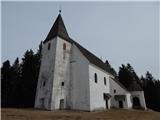 92
92 93
93