Suhadolnik - Kokrska Kočna (on southwest ridge)
Starting point: Suhadolnik (901 m)
Starting point Lat/Lon: 46.3352°N 14.5102°E 
Path name: on southwest ridge
Time of walking: 6 h 30 min
Difficulty: very difficult pathless terrain
Difficulty of skiing: very demanding
Altitude difference: 1619 m
Altitude difference (by path): 1619 m
Map: Kamniške in Savinjske Alpe 1:50.000, Grintovci - 1 : 25 000
Access to starting point:
From highway Ljubljana - Jesenice we go to the exit Kranj - vzhod and follow the road ahead in the direction of Jezersko, but only to the village Kokra. In the mentioned village, we will only few meters before the road crosses a bridge over the river Kokra, notice a road which runs towards Suhadolnik. The turn-off of the road is located, when we are on the right side of the river (left bank), the road sign is approximately 7 km. We follow this road to a parking lot, which is located approximately 300 meters before a farm Suhadolnik.
Path description:
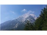
From the parking lot at Suhadolnik we go towards the saddle Kokrsko sedlo, but only to a cirque Suhi dol. Here we choose the second left turn off and we follow steep cart track to the spot, where by the sharp right turn into a forested slope modest footpath branches off (about half an hour from the moment, when in Suhi dol we left the blazes). The path quickly vanishes, and we keep crossing the slopes, until we look into a scenic wall in front of us. After a little unpleasant descent, we cross below the wall and on deer paths on its left edge, we ascend into a dense forest. For a short time, we still cross to the left to a grassy clearing - here we look up and we go on a slope, ascending through a steep gully or on passages right from it.
After the end of the gully, we cross to the left and a little uphill to a grassy plain. In a nice wild environment steep southern slopes of Kočna show up; we move forward in the direction of a rocky top of Mala vratca and we will quickly run into a modest wooden ladder. Above it, we move forward over individual grassy-rocky jumps and steep grass to a distinct notch between Mala vratca on the left and the southwest ridge of Kočna, which spans right from it.
On the notch bigger orientational problems end. We continue right and over a short jump, we ascend to a narrow ledge and from there over a steep section (weak II.) on the ridge, where the further path opens up. In front of us is around 500 altitude meters of the ascent on more demanding terrain of the southwest ridge of Kočna, which doesn't exceed I. grade of climbing.
On grass, we ascend to the sharp side ridge and we cross it to the right (cairn). We avoid a rocky ridge tower on a ledge to the right: it will bring us to a juncture with a gully, which will be from now on our permanent companion to the top of Na Križu. When the ridge becomes easier passable, we again ascend on it.
The route is becoming nicer, climbing isn't too demanding; if the ridge becomes too sharp, we look for an easier passage by the gully on the right. Soon after the spot, where a wall on the left side of the ridge gets interrupted by a steep gully, it becomes steeper and in parts shows characteristics of a rugged wall. The terrain is quite wobbly, but holds are mostly good enough, and climbing quite pleasant. On the left we will notice a smaller natural window, on the right we can look for easier bypasses. Soon after this near the peak Na Križu route ends; after the juncture with a northwestern ridge of Kočna after few meters to the left we reach a panoramic peak.
From the top of Na Križu we continue on the ridge towards the east in the direction of Kokrska Kočna. Ridge is quite sharp, but if nature remains lenient, we will be led also by few cairns.
When the ridge becomes too demanding, on the footsteps of predecessors we avoid it to the right (south) and we cross below it (do not turn too low). Follows slightly exposed ledge and individual spots of I. grade of climbing. The terrain is quite crumbly, so additional caution is recommended.
When we return on the ridge a view opens up on Grintovec, and if we look on the left we notice steel cables from the path on Kokrska Kočna. We descend diagonally to the juncture with a marked path, we cross the scree and on in parts secured path we ascend on Kokrska Kočna.
On the way: Na Križu (2484m)
Pictures:
 1
1 2
2 3
3 4
4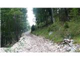 5
5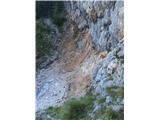 6
6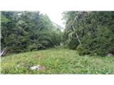 7
7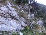 8
8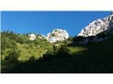 9
9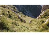 10
10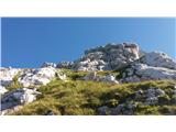 11
11 12
12 13
13 14
14 15
15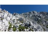 16
16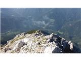 17
17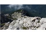 18
18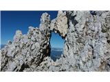 19
19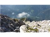 20
20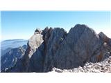 21
21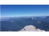 22
22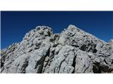 23
23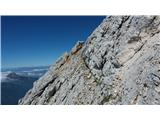 24
24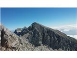 25
25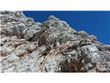 26
26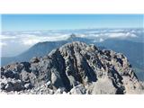 27
27