Tinčkova koča - Vertatscha/Vrtača (on NE ridge)
Starting point: Tinčkova koča (1070 m)
Starting point Lat/Lon: 46.4228°N 14.1991°E 
Path name: on NE ridge
Time of walking: 4 h
Difficulty: rock climbing ascent
Difficulty of skiing: no data
Altitude difference: 1111 m
Altitude difference (by path): 1111 m
Map: Stol in Begunjščica 1:25000
Access to starting point:
From highway Ljubljana - Jesenice we go to the exit Lesce and follow the road ahead in the direction of Žirovnica and Jesenice. After few km of driving, we will get to a crossroad, where the road in Žirovnica and Moste branches off to the right (from the direction of Jesenice left). Only few meters ahead in the next crossroad, we turn left in Moste (right Žirovnica). Further, we drive past a monument to fallen soldiers, where the road starts ascending on a hill below the railway track. On top of the slope, we turn right (at the sign Vila Karin), and then drive towards the lake Završniško jezero and Valvasorjev dom. The road then flattens and it brings us to a crossroad, where the road towards the mountain hut Valvasorjev dom branches off to the left, and we continue straight on at first still asphalt road. The road soon becomes a macadam, and we follow it approximately 5 km to the parking lot near the mountain hut Tinčkova koča. The road in the upper part is often in quite bad condition, so we can park earlier, for instance at the end of the mountain pasture Pri Žagi, where the road again turns in the forest, which extends the path for 15 minutes.
Path description:
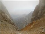
From the mountain hut Tinčkova koča we follow the marked path towards the mountain hut Dom pri izviru Završnice, and from there we continue on a marked path towards Zelenica. When 5 minutes from the mountain hut Dom pri izviru Završnice the valley widens and flattens, we turn left and through the forest and dwarf pines we come on a marked path Zelenica - Stol. We follow it in the direction of Stol to the right turn-off of the footpath upwards through dwarf pines into a cirque Suho rušje. We continue on a footpath past the boulders to a gable of the cirque. On the saddle Žleb, we need to go to the left and below the wall of Zelenjak we need to cross to the notch between Zelenjak and Vrtača. Some initial crumbly edges we avoid a little to the left, then on the ridge we reach a foot of the wall. On a distinct ramp/fissure we climb right upwards to a barrier. Here follows the most difficult part, from the ramp we climb straight upwards by a larger rock on our right side (for the left handed there somehow aren't any good holds) and above it on some easier crumbling terrain to the left upwards we reach the edge of the ridge. (cairn) Follows some unpleasant meters of a very steep and crumbly climbing (don't go too much to the right), and above the band, the main problems end.
In less steep terrain to the right upwards we reach a more compact rock and over a short steep jump we climb on the edge. On the edge (harder, below we withdraw a little on the left side) or right from it (more crumbly) we soon climb on the upper shoulder. To the top of Vrtača follows an easier, but crumbly end of the ridge.
Difficulties are II. (-III.) grade
Route isn't equipped.
Pictures:
 1
1 2
2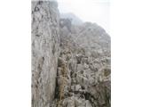 3
3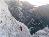 4
4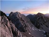 5
5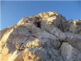 6
6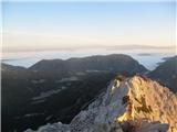 7
7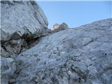 8
8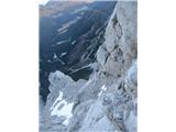 9
9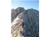 10
10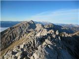 11
11 12
12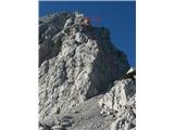 13
13