Uskovnica (Razpotje) - Koča na Uskovnici
Starting point: Uskovnica (Razpotje) (1215 m)
Starting point Lat/Lon: 46.3267°N 13.9107°E 
Time of walking: 20 min
Difficulty: easy marked way
Difficulty of skiing: easily
Altitude difference: -61 m
Altitude difference (by path): 5 m
Map: Triglav 1:25.000
Access to starting point:
A) We leave Gorenjska highway at exit for Lesce, and then we follow the signs for Bled and Pokljuka. Further, we drive through Gorje and past the ski slope Zatrnik to Rudno polje on Pokljuka, where there is a large payable parking lot, and nearby there are also barracks and shooting range. From here we continue straight on a macadam road which a little further brings us to a crossroad, where we continue left in the direction of Uskovnica (right mountain pasture Konjščica). From here we drive good 500 meters to the former parking lot above Uskovnica. This area is called Razpotje.
Now on the mentioned parking lot it is prohibited to park, so we have to park already on Rudno polje, which extends the path for approximately 35 minutes, or we choose starting point Uskovnica (Lom).
B) From Železniki or Podbrdo we drive to Bohinjska Bistrica, and then we continue driving in the direction of Bled. Soon after Petrol gas station, which is located only a little after Bohinjska Bistrica, we continue driving left in the direction of Pokljuka and Jereka. Further, the road at first steeply ascends, and after Korita gradually flattens and it brings us to a crossroad by bus stop, where we continue right in the direction of Pokljuka, Koprivnik and Jereka (straight Srednja vas). Immediately after the crossroad, we get to Jereka, and from the crossroad in front of the church we continue straight towards Pokljuka (left Podjelje). After Jereka the road again starts ascending steeper, and higher flattens and continues by stream Mrzli potok. When we join the road from Bled we go left and we drive to Rudno polje, where there is a large payable parking lot, and nearby there are also barracks and shooting range. From here we continue straight on a macadam road which a little further brings us to a crossroad, where we continue left in the direction of Uskovnica (right mountain pasture Konjščica). From here we drive good 500 meters to the former parking lot above Uskovnica. This area is called Razpotje.
Now on the mentioned parking lot it is prohibited to park, so we have to park already on Rudno polje, which extends the path for approximately 35 minutes, or we choose starting point Uskovnica (Lom).
Path description:
From the former parking lot at the crossroad we continue on for public traffic closed macadam road in the direction of Uskovnica. The road immediately starts quite steep descending and it quickly brings us to a bridge over Ribnica (Ribnica is a stream, which separates Uskovnica from Pokljuka). Behind the bridge road turns sharply left and then in a gentle descent crosses the slopes above the right bank of Ribnica. Some 10 meters ahead the road which leads towards the mountain pasture Konjščica branches off to the right, and we continue straight to the next crossing, which is located right next to a chapel Mary Queen of Peace. Here to the right goes another path towards the mountain pasture Konjšica, straight on the right side of the chapel goes path towards the mountain hut Vodnikov dom na Velem polju and Triglav, and we continue left towards the mountain hut Koča na Uskovnici. We continue on the road which soon crosses the fence, after that near the mogul meadow we continue once again left in the direction of the mountain hut Koča na Uskovnici. From the last crossing to the hut we have only about 50 meters of walking.
On the way: Kapelica na Uskovnici (1180m)
Trip can be extended to: Planina Zajamniki
,
Planina Konjščica (1 h 5 min)
,
Planina pod Mišelj vrhom (4 h)
,
Velo polje (3 h 30 min)
,
Vodnikov dom (3 h 15 min)
,
Ablanca
,
Jezerski Stog (5 h 15 min)
,
Viševnik
,
Mali Draški vrh (3 h 10 min)
,
Vernar (4 h 30 min)
,
Veliki Draški vrh
,
Tosc (4 h)
,
Dom Valentina Staniča (6 h 15 min)
,
Dom Planika (4 h 45 min)
,
Triglavski dom na Kredarici (5 h 15 min)
,
Triglav (6 h)
Pictures:
 1
1 2
2 3
3 4
4 5
5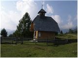 6
6 7
7 8
8 9
9 10
10 11
11 12
12 13
13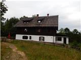 14
14 15
15