Weinebene - Hühnerstütze (Golica/Koralpe)
Starting point: Weinebene (1668 m)
Starting point Lat/Lon: 46.8401°N 15.0162°E 
Time of walking: 2 h
Difficulty: easy marked way
Difficulty of skiing: no data
Altitude difference: 321 m
Altitude difference (by path): 400 m
Map:
Access to starting point:
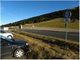
A) Via one of the border crossings with Austria (Korensko sedlo, Karawanks Tunnel, mountain pass Ljubelj, mountain pass Jezerski vrh, mountain pass Pavličev vrh) we drive to Austria, and then we continue driving on the so-called southern motorway towards Graz. On the mentioned motorway we drive to the settlement Wolfsberg, where we leave the motorway, and when we get to the old or regional road we continue driving in the direction of the settlement St. Gertraud. In the settlement St. Gertraud we notice signs for the alpine pass Weinebene, which point us to the right on an ascending asphalt road. On the mentioned road, we drive approximately 18 km, and then we get to the mentioned alpine pass, which is situated at an altitude of 1668 m. We park on a large marked parking lot by the pass.
B) Via the border crossing Holmec or Vič we drive to Austria, and then we continue driving towards the settlement Wolfsberg. From Wolfsberg we continue on a regional road in the direction of the settlement St. Gertraud. In the settlement St. Gertraud we notice signs for the alpine pass Weinebene, which point us to the right on an ascending asphalt road. On the mentioned road, we drive approximately 18 km, and then we get to the mentioned alpine pass, which is situated at an altitude of 1668 m. We park on a large marked parking lot by the pass.
C) First, we drive to Maribor, and then we continue driving on the motorway towards the border crossing Šentilj and further on the Austrian motorway towards Graz. We leave the mentioned motorway at the exit for the settlement Lipnica / Leibnitz. When we leave the motorway at the roundabout, we continue in the direction of the settlement Lipnica / Leibnitz and further we drive south from the village Gralla, which is today already some kind of peripheral part of Lipnica. Further, the road leads us past an industrial or commercial zone, and at the roundabout by the Hofer store we continue "straight" on the second exit in the direction of the settlement Lonč / Deutschlandsberg. Further, we drive on the main road for some time, and after the village Graschach we turn right in the direction of the settlement Lonč / Deutschlandsberg. In a roundabout right next to the settlement Lonč / Deutschlandsberg, we continue "straight" in the direction of the alpine pass Weinebene. From here on, the road starts to ascend more steeply, and we follow it approximately 20 km to the already mentioned pass, where we park on a well-maintained parking lot.
Path description:
From the pass Weinebene we continue towards the southwest, where by the mountain hut Weinebenehaus (a little away there is also the mountain hut Göslerhütte) mountain signposts for Gr. Speikkogel (Gr. Speikkogel is the highest peak of Golica / Koralpe), Jauksattel / Kleinalp, Grillitschhütte, Großhöllerhütte and Koralpenhaus point us on a gentle macadam road which ascends over a gentle grassy slope. The marked path which continues on the road soon crosses a pasture fence, which after a few minutes brings us to a small saddle, from which a nice view opens up towards the highest peak of Golica and on peaks north to northeast from the mentioned peak. When the road starts descending, a parallel marked mountain path branches off slightly to the right, which continues through extensive pastures. When the path stops gently descending, it slightly ascends and returns to the road, which is already from the very beginning closed to public traffic. Further, the road gently to moderately ascends on the southeastern slopes of the peak Brandhöhe (1886 m (Brandhöhe is a peak which is situated above the ski lifts of the ski area Weinebene)), a little further also of the peak Moschkogel (1916 m). When we get to the slopes of the latter peak, the road starts descending more steeply towards the saddle, which is located south of the mentioned peak.
On the saddle, where there is a marked junction, we arrive from Austrian Steiermark to Austrian Kärnten, and we continue straight in the direction of the peak Gr. Speikkogel and continue the path on the right western side of the pasture fence (slightly right Gr. Speikkogel - path past the cross Schäferkreuz and hut Großhöllerhütte, right hut Grillitschhütte).
At the sign which indicates that we have entered Kärnten we leave the road and continue the path along the pasture fence at first only gently upwards. Further, the increasingly steep path still leads on the right side of the pasture fence and with increasingly beautiful views after approximately half an hour of additional walking brings us to the summit and gentle slope of the peak Hühnerstütze (1989 m). Here the path turns slightly to the right and then gently ascends along the edge of an indistinct ridge. A few minutes higher we reach the mentioned peak, from which a nice view opens up.
From the indistinct peak we can continue for approximately 10 minutes on the marked path towards the highest peak of Golica, where we arrive at a point at 2005 metres (even though the mentioned point is higher than the peak itself, the peak named Hühnerstütze is a little lower).
Pictures:
 1
1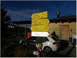 2
2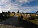 3
3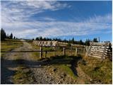 4
4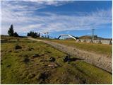 5
5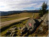 6
6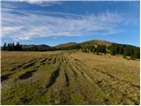 7
7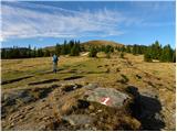 8
8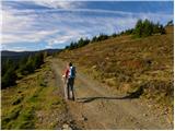 9
9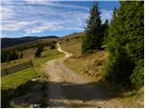 10
10 11
11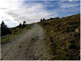 12
12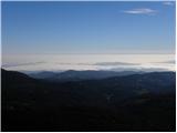 13
13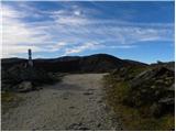 14
14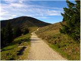 15
15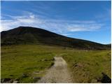 16
16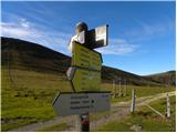 17
17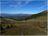 18
18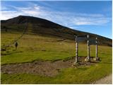 19
19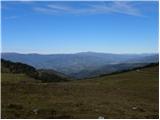 20
20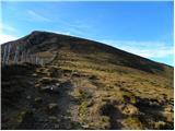 21
21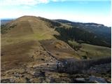 22
22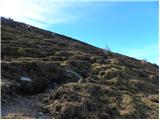 23
23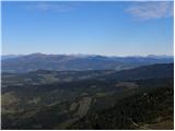 24
24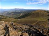 25
25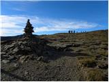 26
26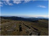 27
27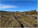 28
28 29
29 30
30 31
31 32
32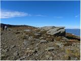 33
33 34
34