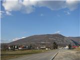
Za koridorjem - Sabotin (on ridge)
Starting point: Za koridorjem (200 m)
Starting point Lat/Lon: 45.9847°N 13.6229°E 
Path name: on ridge
Time of walking: 1 h 15 min
Difficulty: easy marked way
Difficulty of skiing: no data
Altitude difference: 409 m
Altitude difference (by path): 409 m
Map: Goriška - izletniška karta 1:50.000
Access to starting point:
From the direction Bovec -Tolmin we drive on the road Soška cesta towards Nova Gorica to the traffic light crossroad above the cemetery in Solkan. Here we turn right and we drive on the bridge over the river Soča into Goriška Brda.
From other directions we drive to Nova Gorica and we follow the signs Bovec -Tolmin. If we drive through Nova Gorica and Solkan, then at the end of the Solkan we drive left on the bridge over the river Soča into Goriška Brda. If we drive past Nova Gorica we follow the signs for Bovec -Tolmin and on Solkan bypass road we reach traffic light crossroad above the cemetery in Solkan. Here we turn left and then we go immediately right on the bridge over the river Soča into Goriška Brda.
The road right behind the bridge starts ascending. After two large turns we drive past the parking lot on our left and 500 meters higher on our right we notice stairs, which lead on Sabotin on the south path. Soon after the stairs we get to Italy, where the road flattens. After approximately 1 km of driving on "corridor" through Italy, the road under the overpass starts descending. At the turn we slow down, because immediately, when we drive under the next overpass, we get to Slovenia. Here we have to immediately turn left on a smaller parking lot. On our right we see stairs, which lead on Sabotin on the path Za koridorjem.
.
Path description:
On Sabotin there are numerous paths on the Slovenian and Italian side, which intertwine each other, so on that nice and extremely interesting hill we can hike by current inspiration.
The path Za koridorjem is less visited as for majority more popular south path. But it is more appropriate for the ascent on Sabotin from the spring ahead, when the temperatures on the south slopes quickly rise to suffocating heat. The path from the beginning isn't that panoramic as south path, but it is a little steeper.
On this path as well we will need a good footwear and in warmer days a lot of fluid, because Sabotin isn't difficult because of its height, but because of the heat.
Sabotin is a hill of special energy, which will impress you in all seasons. Most beautiful is spring, when it blooms and in the late autumn, when its the slopes get red by smoke tree. In the winter we will be on its south slopes warmed up by the sun, and in the summer there is too hot even for vipers. Most appropriate time for visiting Sabotin is from September to May. And later only very early in the morning or with a car. To the mountain hut and snack bar, which are in premises of the former border building right below the summit, you get on an asphalt road from Goriška Brda. In the snack bar there is a mini museum, and yu can arrange a guided tour of caverns, which are illuminated and settled.
From the parking lot, we cross the road and we ascend on stairs. The path is already from the beginning quite moderately ascending through a thin forest, which in warmer days offers some shade.
When the path after few turns first time flattens, we will on our right notice a footpath. It brings us to an asphalt road on the Italian side, which leads from the village Šentmaver / San Mauro to Italian border building on Sabotin. To the mentioned path we can higher few times get closer to and we can use it when returning.
We continue with the ascent on normal path, which is ascending on with logs supported slope and after few minutes it brings us to cavern with an interesting arched entrance, where we turn left. If we would follow the footpath to the right, we would in few steps get to the road from the village Šentmaver.
The path from the cavern is still ascending and after five minutes it brings us on a rocky turn, from where a nice view opens up on river Soča, which is winding towards the sea and on ossuary - monument of the fallen in the 1st world war on Oslavje / Oslavia (white round building in Italian Brda / Collio).
After additional 15 minutes we get to a macadam path, where there is also a bench for a short rest. Macadam path comes from the nearby turn of the asphalt road which runs on Sabotin from Goriška Brda and after few meters joins the road which runs on the Italian side from Šentmaver. If from the mountain hut or snack bar on Sabotin we don't feel like going on the ridge, we then descend on the road to this turn, where we join the path Za koridorjem. And all, who come on Sabotin with a car can park on a turn, and continue walking on the path from this description. So you will effortless enjoy most beautiful part of Sabotin.
From the crossing at the bench we turn right and after few steps, we get to the road in Italy at 5th turn / tornante. There we are mildly ascending to the next, 6th turn. A little before 6th turn we will on our left notice a marked footpath which very steeply ascends to Italian border building and from here to the summit of Sabotin. We continue to 6th turn, where we turn on a cart track which from the road branches off on our right, and still in a gentle ascent, we cross southern slopes of Sabotin. On the cart track, we can continue to the ruins of the church of St. Valentin and from here we continue on the ridge, on which leads south path. From the bench to the church there is approximately 15 minutes, and from the church to the top Sabotin another 20 minutes of moderate walking.
Instead of going to the church, we can already few minutes earlier turn on a footpath, on which a cairn on our left side points us to. The path moderately ascends through a pine forest, and further it is mostly mildly ascending through karst woods right below the ridge of Sabotin. From the bench to the turn off on a footpath there is approximately 10 min, and from here to the top of Sabotin another 15 minutes of moderate walking.
Which path to choose, depends mainly from weather. If the weather is nice and it is not windy, we then decide for path to the church and ahead on a scenic rocky ridge, on which runs border between Slovenia and Italy, so we can walk with each foot on one country. The path is in nice weather very panoramic. In front of us are rising Julian Alps, right below us river Soča and above it Sveta Gora, on our left view reaches all the way to the sea and on Goriška Brda and Italian Brda / Collio, Friulian plain and Dolomites at the back. And behind us is rising Trnovo plateau, and below it a look reaches through the valley Vipavska dolina to Nanos and Vremščica. In the valley below us are Nova and Stara Gora, and behind them Kras and the sea.
If it is very windy, we then decide for path below the ridge on the Italian side. From this path we have all the time view on Brda and river Soča, which is winding to the sea, and in clear weather a look reaches all the way to Dolomites. The footpath below the ridge is the exact opposite of the rocky path on the ridge, because it runs through a nice karst woods, where in warm days we enjoy pleasant smells of grass and wild herbs, and in the autumn we enjoy red leaves of smoke tree.
It is best, that you walk the path in circular way (past the church up, below the ridge down).
The path from the ridge into a valley we can also extend:
Option 1:
If we go on the ridge to the church of St. Valentin, we then continue on the south path past the former caption Naš Tito. We follow the path few more turns, until we go past the newly made path. We continue on an old path, until it turns left, and we continue straight past a bigger rock, where we soon step on the Italian side. The path is slightly rising and descending, until it brings us to the log cabin. From here on we are mildly descending on a cart track to a crossing at the bigger rock, where we continue right upwards. Left downwards we join the south path. The path on a cart track is mildly rising to the road which comes from Šentmaver. We continue downwards on the road to 3rd turn / tornante, where on a small footpath we join the path Za koridorjem right below the cavern with an arched entrance.
Option 2:
If is we go on the path below the ridge, we continue to a cart track which comes from the church of St. Valentin. Here instead of right towards the road and bench at the turn number 5, we turn few steps to the left (in the direction of the church) and we continue on a marked footpath which is descending from the cart track right. The footpath in the lower part flattens and later it splits into two parts. If we turn left, we join the south path below the former caption Naš Tito. From here we continue as it is described under option 1.
If we go right, our path will soon start very steeply descending on rocky terrain to footpath which comes from the south path, as it is described under option 1. We continue to the right and we soon get to the log cabin. From here on we are mildly descending on a cart track to a crossing at a big rock, where we continue right upwards. Left downwards we join the south path. The path on a cart track is moderately rising to the road which comes from Šentmaver. We continue downwards on the road to 3rd turn / tornante, where on a small footpath we join the path Za koridorjem right below the cavern with an arched entrance.
Nothing serious, if we forgot where to turn and we came almost to the end of the south path. Instead that we turn left on a footpath which brings us on stairs on the south path, we continue straight on a marked path, which comes from the village Šentmaver. After few minutes descent we get to narrower road which leads above the corridor of the road towards Goriška Brda. We continue to the right and we walk the road to the end of corridor. Here we join the road which runs on Sabotin from the village Šentmaver. We continue on the road to the right upwards only few meters and then we continue on a cart track which we see on the left side. After few minutes of crossing the slopes, we come on the Slovenian side on the path Za koridorjem. From here only a short descent follows to the parking lot.
Higher above the corridor of the road (after the second wire fence) leads also a footpath which is in parts very overgrown, therefore it is easier and faster, if we walk the corridor on the road.
Pictures:
 1
1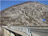 2
2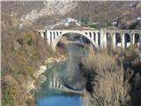 3
3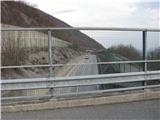 4
4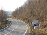 5
5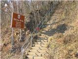 6
6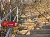 7
7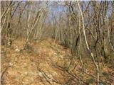 8
8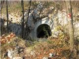 9
9 10
10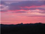 11
11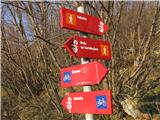 12
12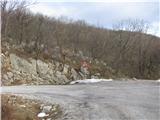 13
13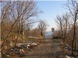 14
14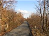 15
15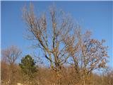 16
16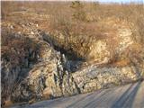 17
17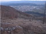 18
18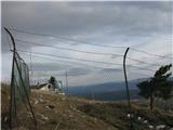 19
19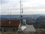 20
20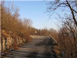 21
21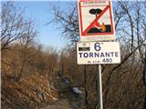 22
22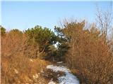 23
23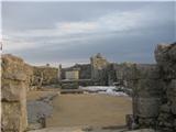 24
24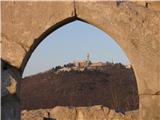 25
25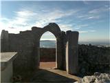 26
26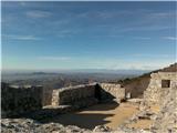 27
27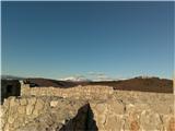 28
28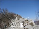 29
29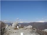 30
30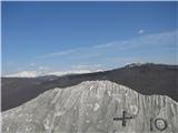 31
31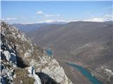 32
32 33
33 34
34 35
35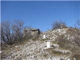 36
36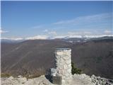 37
37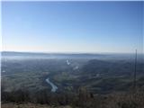 38
38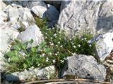 39
39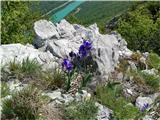 40
40 41
41 42
42