Zadnjica - Križ (via Dovška vrata)
Starting point: Zadnjica (642 m)
Starting point Lat/Lon: 46.3824°N 13.7604°E 
Path name: via Dovška vrata
Time of walking: 5 h 45 min
Difficulty: difficult marked way
Difficulty of skiing: very demanding
Altitude difference: 1768 m
Altitude difference (by path): 1790 m
Map: TNP 1:50.000
Access to starting point:
From Kranjska Gora, drive over Vršič Pass towards Bovec or vice versa, but only to the 50th hairpin turn of the Vršič or Russian road (near the village of Trenta). Here turn onto the side road, along which we park after a few hundred metres at the roadside parking lot.
Path description:
From the parking lot continue along the road, which takes us past a few houses (mainly holiday cottages) in about 15 minutes to the place where the road splits into two parts (there used to be a parking lot at the junction, parking is now prohibited).
From the old parking lot take the left road towards Pogačnikov dom at Kriški podi (right road leads towards Prehodavci and Dolič). After 15 minutes of further walking the road brings us to the lower station of the goods cableway, where it ends.
Continue the ascent along the marked footpath (mulatjera), which moderately ascends through the forest. The path, which ascends above the valley of Beli potok, soon brings us to very steep slopes (danger of falling rocks), across which a very wide footpath leads. The path further crosses the gully Veliki Presek, after which we reach a short exposed ledge, crossed with the aid of a fixed wire rope. Further the path returns to the forest, where it moderately ascends in numerous zigzags. A bit further the path brings us under a small overhang, where we can notice numerous sticks that hikers place so that the rock does not collapse into the valley (the sticks are placed more for fun than seriously). The path further crosses a few smaller gullies, then past a chapel brings us to a larger gully. With some caution (easy) we cross the mentioned gully, after which in a few minutes of further walking we ascend to a pleasant rest area (two benches by the path). Further we cross another large gully (possibility of snow patch in early summer), then the path returns to the forest. Higher up the forest becomes sparser, the path somewhat steeper and increasingly scenic.
The path, which continues ascending along the old mulatjera, then past two more benches brings us to the dwarf pine belt, after which we pass into rockier terrain. Further we ascend over smaller screes along an increasingly scenic path, which higher up brings us to a pleasant spring (source).
Just some 10 steps above the mentioned spring, we arrive at an unmarked junction, where an unmarked path branches right towards Spodnje Kriško jezero (2 minutes), we continue slightly left along the still wide alpine path. The path further leads us past smaller dwarf pine remnants, we follow it all the way to the marked junction, where we continue right towards Pihavec, Bovški Gamsovec, Stenar and Vrat valley (left Pogačnikov dom 3 minutes). Continue the ascent along the increasingly scenic path, from which soon a path to Pihavec branches right. Continue straight along the moderately steep path, which higher up brings us to Dovška vrata, where the next junction is.
Here continue straight towards Križ and Stenar (sharply right Bovški Gamsovec, right Vrata) along the path which gradually starts to ascend towards Stenarska vratca. After a few minutes of ascent the path splits into two parts. Continue left (right Stenar) along the path which from scree passes to slightly exposed slopes, which we cross in moderate ascent towards northwest. The fairly slippery path then brings us higher under the summit foot of Križ. Here the path steeply rises and brings us to a somewhat exposed ridge, where with the help of a peg and fixed wire rope we ascend to the panoramic summit.
Starting point - Na placu 0:15, Na placu - lower station of goods cableway 0:15, lower station of goods cableway - Na Utrci 2:00, Na Utrci spring under Kriški podi 1:05, spring under Kriški podi - Spodnje Kriško jezero 0:05, Spodnje Kriško jezero - Pogačnikov dom 0:20, Pogačnikov dom - Dovška vrata 0:45, Dovška vrata - Stenarska vratca 0:20, Stenarska vratca - Križ 0:40.
Pictures:
 1
1 2
2 3
3 4
4 5
5 6
6 7
7 8
8 9
9 10
10 11
11 12
12 13
13 14
14 15
15 16
16 17
17 18
18 19
19 20
20 21
21 22
22 23
23 24
24 25
25 26
26 27
27 28
28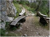 29
29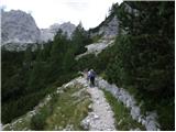 30
30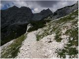 31
31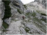 32
32 33
33 34
34 35
35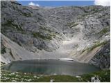 36
36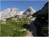 37
37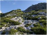 38
38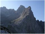 39
39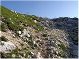 40
40 41
41 42
42 43
43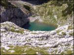 44
44 45
45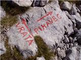 46
46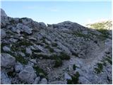 47
47 48
48 49
49 50
50 51
51 52
52 53
53 54
54 55
55 56
56 57
57 58
58 59
59 60
60 61
61 62
62 63
63 64
64 65
65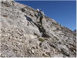 66
66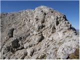 67
67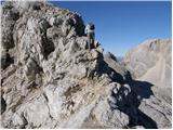 68
68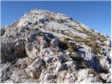 69
69 70
70