Zadnjica - Triglav (Kugyjeva pot)
Starting point: Zadnjica (650 m)
Starting point Lat/Lon: 46.3824°N 13.7604°E 
Path name: Kugyjeva pot
Time of walking: 7 h 30 min
Difficulty: very difficult marked way, difficult unmarked way
Difficulty of skiing: no data
Altitude difference: 2214 m
Altitude difference (by path): 2214 m
Map: Triglav 1:25000
Access to starting point:
From Bovec, we drive through the valley Trenta to the settlement Trenta. After the center of the settlement, the road descends to the bridge over Krajcarca and after 350 meters reaches the first (from the direction of Kranjska Gora the) hairpin turn of Vršič road. At this sharp left turn to the right into the valley Zadnjica a macadam road branches off (from the direction Kranjska Gora to the left), which after 150 meters brings us on a marked parking lot.
Path description:
From the parking lot, we continue on the road, and past few houses (mainly holiday cottages) in approximately 15 minutes it brings us to the spot, where one road branches off left upwards (at the crossroad used to be a parking lot, today it is forbidden to park).
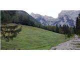
We continue on the road straight (on the upper road we get to the bottom station of the cargo cableway and beginning of mule track which leads on Pogačnikov dom) in the direction of Dolič, Luknja and Prehodavci. At first, a gently sloping road which leads us through panoramic meadows, and higher through the forest, we follow to its end, where it narrows into a mule track and brings us on the bridge over Zadnjica (altitude 1000m, to here we need approximately one hour). Here to the left a view opens up towards the saddle Luknja, above us (towards the south) proudly stands Kanjavec with its mighty wall, and a little to the right we have a view on Zadnjiški Dol, on which the path is winding on Prehodavci. At this spot there is the last option to get fresh water.
We continue the ascent on a mule track, which is at first ascending through the forest, and higher it is in numerous hairpin turns overcoming steeper slopes and is oriented towards Luknja. At an altitude around 1500m we come to a crossing, where our mule track turns to the right (direction Dolič), and straight the path branches off towards Luknja. Into a rock carved mule track continues winding above the precipitous slopes and higher as we are, more interesting are the views on numerous walked hairpin turns below us and on grassy slopes of Pihavec on the other site. A little higher, the path crosses a wide crumbly gravel gully, in doing so it makes a sharp turn to the right to the other side of the gully (this gully is the end of the valley, which is oriented up towards Zaplanja and on which we will further walk, for now we continue on a mule track), where in hairpin turns a little higher up it continues through larch forest. When the mule track flattens a little (pointed towards the south), we need to pay attention to the left on some rocky stairs, which from the mule track point us to the left upwards towards the ruins of the former Italian hut Gemona. Which is located just above us and few steps ahead on the mule track it is clearly visible. Here, at an altitude around 1780m, is the beginning of the path Kugyjeva pot. From the ruins of Gemona ahead we cross several screes on a steep slope of Zelenice, on which the path occasionally vanishes. At the crossing of the screes we stay on the same altitude or we are slightly ascending. Further, the path below the steep slopes of Zelenice is again better beaten. At an altitude around 2000m from beneath Zelenice we go left towards the north, with a purpose to cross the valley. Here the path is hard to follow, but the terrain is easy passable, grass is prevailing. Above us, we soon notice a large scree and gable of the valley. Actually there are two gables. The right one, more distinct and narrower, and the left one, just above us. Both gables connects a large scree, which is further our orientation point. It is important, that we go along the left edge (up looking) of the scree. Just right from the left edge of the scree, we can notice slightly vegetated lane of grass. This will after approximately 100 meters bring us to the key point of the path Kugyjeva pot, this is to an old steel cables, which represent the easiest passage from this valley on the ridge of Plemenice, where runs a marked path. The passage over the rocky edge is here the easiest. Three pitches of steel cables, even though old, are still attached into a rock, however they do not give a sense of security. Fortunately the terrain itself isn't that exposed, that they would be urgently needed. Further, the path is again easier to follow and better beaten. In few minutes, the path brings us on scenic steep grassy terrains, and there we go further on the precipitous edge above Korita. From a grassy edge we watch straight downwards towards Luknja. From here the footpath leads ahead on a grassy broad ridge (direction northeast) a little less than 200 meters and then it turns right towards the east, where we walk on high mountain karst plateau. The path after 300 meters brings us to a marked path, which goes from Luknja on Triglav. Few minutes ahead on a marked path and we already can from the edge of Triglav northern wall admire famous Sfinga. From here we further follow the blazes, which through plateau Zahodna triglavska planota and Triglavska škrbina lead to the top of Triglav.
The difficulty of the description refers to unmarked part of the path between mule track for Dolič and secured path via Plemenice (condition September 2020). Because of in some parts poorly visible path, in parts also pathless terrain, I don't recommend to go on this path in fog due to difficult orientation. I also don't recommend a descent in wet weather because of in parts steep grassy slopes.
Pictures:
 1
1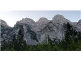 2
2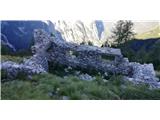 3
3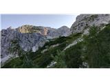 4
4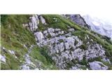 5
5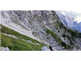 6
6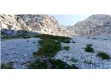 7
7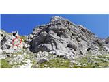 8
8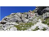 9
9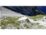 10
10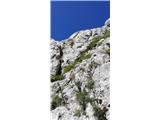 11
11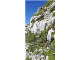 12
12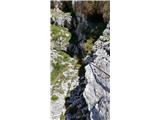 13
13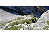 14
14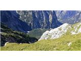 15
15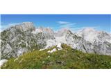 16
16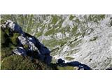 17
17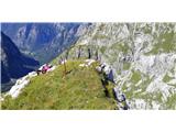 18
18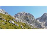 19
19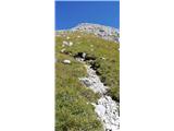 20
20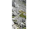 21
21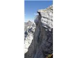 22
22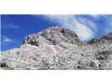 23
23