Zeller Kreuz - Teufelsteinalm
Starting point: Zeller Kreuz (1232 m)
Starting point Lat/Lon: 47.44492°N 15.62592°E 
Time of walking: 35 min
Difficulty: easy marked way
Difficulty of skiing: no data
Altitude difference: 158 m
Altitude difference (by path): 158 m
Map:
Access to starting point:
Highway A2 Graz - Vienna / Wien we leave at the exit for Gleisdorf West, and then we follow the signs for Hartberg and Weiz, and later only Weiz. At the beginning of the town Weiz, we exit the roundabout in the direction of the exit for the settlement Birkfeld and then follow the road all the way to the mentioned settlement. From there, we follow the signs for the settlement Fischbach, but we drive a little further beyond the settlement Fischbach, where, after the settlement Gmoa, we arrive at the arranged parking lot by the cross Zeller Kreuz, where the described path begins.
Path description:
From the parking lot, we head onto a side macadam road, marked with signs for Teufelstein, Alpl, and Stanglalm, and begin gently to moderately ascending through the forest. We soon reach a small crossroad, where a path from the settlement Fischbach joins from the right, and we continue on the slightly left road, which keeps ascending through the forest, passing individual benches along the path. Higher up, a view briefly opens towards the east, and we continue along the road to a marked crossing, from which we turn right onto a footpath towards the summit Teufeltein (straight to Stanglalm). The footpath quickly leads us to another road, which we reach at a marked crossroad, and from there we continue straight onto a wider cart track, along which the marked path continues towards the summit Teufelstein.
Next follows a short ascent, and we arrive at the cottage Teufensteinhütte on the mountain pasture Teufensteinalm.
The description and pictures refer to the condition in October 2023 and June 2024.
Pictures:
 1
1 2
2 3
3 4
4 5
5 6
6 7
7 8
8 9
9 10
10 11
11 12
12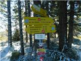 13
13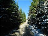 14
14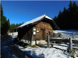 15
15