Zgornja Rečica (church of Blessed Anton Martin Slomšek) - Gozdnik
Starting point: Zgornja Rečica (church of Blessed Anton Martin Slomšek) (365 m)
Starting point Lat/Lon: 46.17004°N 15.15818°E 
Time of walking: 3 h 25 min
Difficulty: easy marked way
Difficulty of skiing: no data
Altitude difference: 725 m
Altitude difference (by path): 795 m
Map:
Access to starting point:
We drive into Laško, and then at the traffic light crossroad we drive in the direction of Spodnja Rečica. Further on, Laško ends, and we arrive in Spodnja Rečica, and later also in Zgornja Rečica, where we drive to the parking lot by the cemetery below the church of Blessed Anton Martin Slomšek.
Path description:
On the road, on which we came to the starting point, we return a few minutes back, and then we turn onto a side road, by which there are signs for Šmohor. A few minutes we ascend on a grassy part, and then the road passes into the forest, where at a few crossroads we follow the blazes. We leave the asphalt road slightly below the farm Brezovar, where we turn right, and then we ascend to the mentioned farm, where we continue through the yard; above the farm, the path passes into the forest and continues on a cart track. The cart track first ascends diagonally towards the right, then flattens and crosses some smaller streams, where the path becomes gradually more overgrown; a little further, it leaves the cart track and turns left onto a footpath, by which the blazes continue, and for a few minutes becomes entirely overgrown with tall grass, young bushes, and partly with blackberries.
The overgrown part we traverse in a diagonal ascent towards the right; the path becomes easier to pass when we reach a forested cart track, on which we continue to a meadow near the homestead Štitnikar, where we turn left towards signs for Šmohor. The path ahead leads us on a cart track that returns to the forest; at the first crossing, we go right, at the second straight, and then signs for Šmohor direct us to the right, initially slightly downwards, onto a cart track that continues without significant changes in altitude, crossing the slopes towards the right. In the last part of the crossing, we walk on grassy terrain, and the farm, which we reach in a few minutes, we bypass on the lower right side.
At the farm, we also reach the road, to which, a little further, a path from the starting point in Spodnja Rečica joins from the right.
Here we continue straight, and along the road we walk to the first crossroad or junction, from which we turn left (sharply left toward the church of Sveti Mohor - the path that bypasses the cottage Dom na Šmohorju, straight to Malič and Laško), and we continue walking along the marked hiking trail, which leads us in three minutes of further walking to the mountain hut Dom na Šmohorju.
From Dom na Šmohorju we continue in the direction of Kal, Mrzlica and Gozdnik. The path ahead at first crosses a larger meadow, and then passes into a lane of a forest, through which it descends to the nearby road. When we step on the road, we continue in the same direction, and we walk there to the spot, where it splits into two parts. This time we continue on the left road, on which in few 10 strides we get to the church of St. Mohor.
From the church, by which there grow numerous old linden trees, we descend on a marked hiking path, and it soon returns on a macadam road. We continue on the road which on the right side bypasses the peak Pernice, and then it starts moderately descending and it brings us to a marked crossroad. From the crossroad, we go in the direction of Kal and Mrzlica and we continue on a bit narrower macadam road which past a religious symbol and a well brings us to the next crossroad, where we continue straight. The road then flattens and after few 10 meters brings us to the spot, where signs for Kal, Mrzlica and Gozdnik point us to the right on an ascending cart track. The path ahead leads us past NOB monument, after which we soon get to the next crossing. This time we continue right in the direction of Gozdnik (slightly left downwards Mrzlica), and we continue on a cart track to the spot, where the forest gets a little thinner. Here a narrower cart track branches off to the right, by which we soon notice blazes, and gradually it changes into a footpath. The path ahead for a short time steeply ascends, and then it flattens and gradually brings us on the ridge of Mali Gozdnik. Next follows a walk on at first a gentle ridge and then the path steeply ascends and it quickly brings us on an indistinct peak of Mali Gozdnik.
Next follows a short descent and the path brings us on a small saddle between the both peaks of Gozdnik. The path ahead gradually starts ascending steeper and steeper, and it leads on a relatively steep and mainly in wet for slipping dangerous ridge. The path higher flattens and in few minutes of additional walking brings us to the summit, in the middle of which there is a wooden bivouac.
Zgornja Rečica - Dom na Šmohorju 1:40, Dom na Šmohorju - Gozdnik 1:45.
Pictures:
 1
1 2
2 3
3 4
4 5
5 6
6 7
7 8
8 9
9 10
10 11
11 12
12 13
13 14
14 15
15 16
16 17
17 18
18 19
19 20
20 21
21 22
22 23
23 24
24 25
25 26
26 27
27 28
28 29
29 30
30 31
31 32
32 33
33 34
34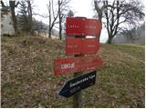 35
35 36
36 37
37 38
38 39
39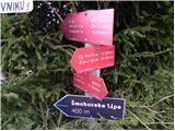 40
40 41
41 42
42 43
43 44
44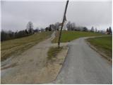 45
45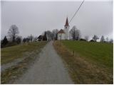 46
46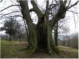 47
47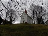 48
48 49
49 50
50 51
51 52
52 53
53 54
54 55
55 56
56 57
57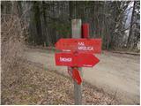 58
58 59
59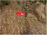 60
60 61
61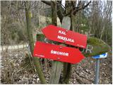 62
62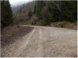 63
63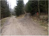 64
64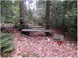 65
65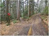 66
66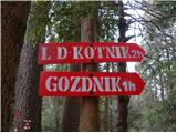 67
67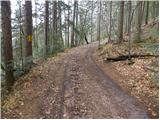 68
68 69
69 70
70 71
71 72
72 73
73 74
74 75
75 76
76 77
77 78
78 79
79 80
80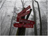 81
81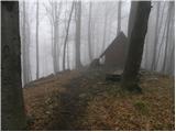 82
82 83
83