Zgornje Jezersko - Žmitkov špic
Starting point: Zgornje Jezersko (880 m)
| Latitude/Longitude: | 46,39520°N 14,49860°E |
| |
Walking time: 45 min
Difficulty: partly demanding marked way
Elevation gain: 244 m
Elevation difference along the route: 244 m
Map: Karavanke - osrednji del 1:50.000
Recommended equipment (summer):
Recommended equipment (winter): crampons
Views: 19.587
 | 3 people like this post |
Access to starting point:
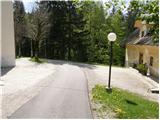
From the Ljubljana - Jesenice highway, we take the exit Kranj - east and follow the road ahead in the direction of Jezersko. At Zgornje Jezersko, at the intersection at the gas station, we turn left towards the church of St. Ožbolt at Jezersko (straight ahead MP Jezersko). We then drive past the hotel Planinka, following the road to the nearby church of St. Ožbolt. We park near the church, or a little lower on the arranged parking lot by the cemetery.
Route description:
From the church, we continue on the asphalt road which moderately ascends and after some ten steps brings us to the spot where it ends. Here we will notice on a tree a signpost for Virnikov Grintovec, which directs us right onto a footpath that gently ascends along the edge of grassy meadows. The path, which then goes into the forest and starts moderately ascending, after 15 minutes of walking immediately behind the stream brings us to the Žmitek homestead, where we also step onto a macadam road.
The marked footpath merely crosses the mentioned road, then starts steeply ascending through dense forest. After a few minutes of steep ascent, we join a gentler cart track which we then follow to a smaller saddle between Olipov rob (another name for Žmitkov špic) on the left and Žmitkov vrh on the right.
On the mentioned saddle we leave the wide marked path which leads towards Virnikov Grintovec and continue left on a less beaten but easy-to-follow path which after less than 5 minutes of further walking brings us below the summit of Žmitkov špic. Here the path steeply ascends, aided by a rope and slightly higher also a short ladder. After approximately 15 m of steep ascent, the path flattens, turns to the left and after a few further steps brings us to the panoramic summit.

Photos:
 1
1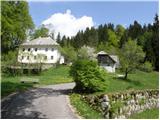 2
2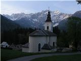 3
3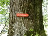 4
4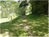 5
5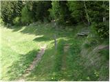 6
6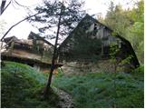 7
7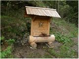 8
8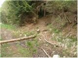 9
9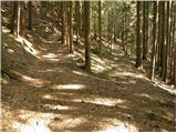 10
10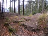 11
11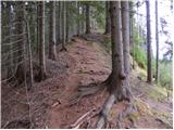 12
12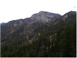 13
13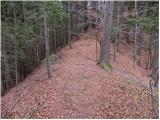 14
14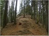 15
15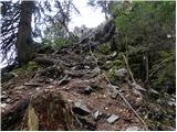 16
16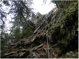 17
17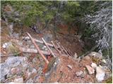 18
18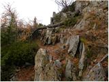 19
19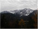 20
20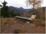 21
21
Discussion about the trip Zgornje Jezersko - Žmitkov špic
|
| Kriška1. 05. 2009 |
This could be quite an interesting trip, but I really miss some additional photo, especially of that more demanding part. In the text I read that it is secured with ropes, I can't quite imagine that well?
|
|
|
|
| klavdy61. 05. 2009 |
I added some more photos. The summit is rocky and at the end it's very steep, so the rope comes in very handy
|
|
|
|
| grega_p20. 11. 2009 |
Really nice afternoon hike with beautiful views, but I would add that despite the subjectivity of time 50 min is still too much. With photographing and moderate walking it took me 35min.
Under the summit be careful, especially if the rocks are wet.
regards!
|
|
|
|
| mt30. 04. 2010 |
Good description, nice views, lojtra and bench super, time maybe a bit stretched.
|
|
|
|
| tisa3. 11. 2010 |
I will definitely put this hike on my list of trips. Best regards and good luck!
|
|
|
|
| VanSims14. 11. 2010 |
I don't know if we are still in Gorenjska, given that the older Jezersko people still consider themselves Carinthians because of the provincial border before WWI somewhere near Spodnje Jezersko, because the markings are not even very Gorenjska-style but unevenly distributed. There at that spring in the eighth picture, you have to be a detective to find the continuation of the path, which is to the left and then up into the forest and not to the right towards the spring, so that after about five minutes of walking we come to a situation where the marking is painted on as many as four consecutive trunks spaced no more than a meter apart.
Then I don't know if that rope in the lower part is intentionally unsecured? When I was there, it was slyly hooked on a branch of the neighboring tree, so it looked attached. Good thing it stayed in my hand before I started climbing.
As for the book in the log at the top, it's not very thoughtfully done, but if two regulars hadn't signed before me, I wouldn't even know that the log is hollow and contains the mentioned book.
|
|
|
To post a comment you must log in:
If you do not yet have a username, you must first
register.