Zgornje Poljčane - Baba (at Boč)
Starting point: Zgornje Poljčane (360 m)
Starting point Lat/Lon: 46.2971°N 15.5834°E 
Time of walking: 35 min
Difficulty: easy unmarked way
Difficulty of skiing: no data
Altitude difference: 234 m
Altitude difference (by path): 234 m
Map: Posavsko hribovje (Boč - Bohor) 1:50.000
Access to starting point:
a) We leave the Ljubljana - Maribor highway at the exit for Slovenske Konjice, then follow the signs for Žiče, Loče, Zbelovo, and Poljčane. In Poljčane, we turn right and drive to Zgornje Poljčane, where we follow the main road until the junction of a side road to the left towards Boč and the mountain hut Planinski dom na Boču. We park above the settlement on a macadam parking lot, near mountain signposts.
b) We leave the Maribor - Ljubljana highway at the Slovenska Bistrica south exit, then follow the road towards Poljčane and Podčetrtek. In Zgornje Poljčane, we follow the main road until the junction of a side road to the left towards Boč and the mountain hut Planinski dom na Boču. We park above the settlement on a macadam parking lot, near mountain signposts.
c) From the Šentjur - Rogaška Slatina road at the settlement Podplat, we turn left (or right from the direction of Rogaška Slatina) towards Slovenska Bistrica and Poljčane. A short ascent follows, and after the Pečica pass, we begin descending. At the start of the settlement Zgornje Poljčane, we turn right towards Boč and the mountain hut Planinski dom na Boču. We park above the settlement on a macadam parking lot, near mountain signposts.
Path description:
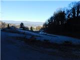
From the starting point, we head along the right path, marked with signs for the path over Baba (straight to Boč via Balunjača and Dom na Boču along path Detičkova pot) and begin ascending through the forest. After a few minutes, we cross an asphalt road leading to Dom na Boču, and we start climbing more steeply. Next follows an ascent along the forested northern ridge of Baba; at an altitude of 535 meters, we reach the Baba rock, located by the marked path, from where a beautiful view opens toward the valley and Pohorje.
Only a little further, the marked path turns slightly to the right, and we continue straight on a poorer unmarked footpath, along which in a few minutes of ascent we reach the peak of Baba.
We can descend along the ascent route, or we continue along the ridge ahead and join the Detičkova pot path, along which we can descend or continue forward towards Boč.
The description and pictures refer to the condition in December 2024.
Pictures:
 1
1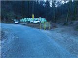 2
2 3
3 4
4 5
5 6
6 7
7 8
8 9
9 10
10 11
11 12
12