Aljažev dom v Vratih - Triglav (via Plemenice)
Starting point: Aljažev dom v Vratih (987 m)
| Latitude/Longitude: | 46,41280°N 13,84660°E |
| |
Route name: via Plemenice
Walking time: 6 h 30 min
Difficulty: very difficult marked way
Via ferrata: B/C
Elevation gain: 1877 m
Elevation difference along the route: 1900 m
Map: Triglav 1:25.000
Recommended equipment (summer): helmet, self belay set
Recommended equipment (winter): helmet, self belay set, ice axe, crampons
Views: 236.931
 | 14 people like this post |
Access to starting point:
We drive to Mojstrana, then follow the signs for Vrata Valley. We continue on the toll road, which is closed to public traffic in winter, following it to the large parking lot located a few minutes before Aljažev dom v Vratih.
Route description:
From the parking lot we continue along the gravel road closed to public traffic, passing Šlajmerjev dom and quickly reaching Aljažev dom v Vratih.
We bypass Aljažev dom on the right and continue straight on the trail towards Triglav, Sovatna, Luknja... (right Škrlatica, bivak na Rušju...). We continue on the rougher gravel road past the winter shelter to the marked junction at the famous peg (monument to fallen partisan mountaineers).
We go straight again (left Tominškova pot), the easy trail leading with fine views of Triglav and the Triglav North Face. After a few minutes we enter a beech forest where the path over Sovatna branches right; we go straight towards Luknja and Triglav - path via Prag. A short climb on the track follows, then markers lead left to the path approaching the bed of Triglavska Bistrica. Here the path passes a memorial to mountain victims and soon reaches the next marked junction.
Left across the stream continues the path via Prag; we go straight on the path which gradually steepens more noticeably. The path to Luknja ascends moderately for a while, then becomes steeper and more panoramic higher up. Higher still, it leads through scrub and sparse woods where a pathlet branches right to a nearby bivouac; we continue on the broader trail emerging from the woods shortly. The path steepens further, leading gradually to screes below Luknja. The scree path is slippery; at the wall base fixed ropes help (easy dry, useful mainly on descent). We climb steeply beside the wall briefly, then the path veers right to a junction at Luknja with fine views to peaks above Zadnjica.
The path now gets very difficult, starting with near-vertical ascent on fixed rope. After the initial wall it eases slightly but difficulties persist. From here few protections and occasionally trail above deep drop. High slip risk when wet! Difficulties ease gradually; path turns left to a ridge with eastward views. We follow the panoramic ridge where the path soon gets demanding again. Using fixed rope and pegs we make steep ascents several times, then a short steep descent. Left opens view to famous Sfinga (steepest Triglav pillar).
Further the path eases, leading over rocky terrain. Trail less visible here, passing left of Glava v Zaplanji and Triglavska vojašnica Viktorja Emanuela III. (formerly wrongly called Morbegna) visible ahead. Even in summer possible snow patches here but not steep, no ice axe needed usually.
The path reaches junction on Western Triglav Plateau. Go left up towards Triglav (right Dolič, sharp right Triglavska vojašnica Viktorja Emanuela III.) over scree to entry of next climbing section. Much easier than Plemenice section, no major issues (just crowds). Path ascends diagonally with numerous protections to below Triglavska or Bovška škrbina. Climb to the notch to junction. Go left up (straight down Planika) on steep but well protected path. After several ascents steepness eases; few minutes up summit slopes to top of Triglav.
Parking lot - Aljažev dom 0:05, Aljažev dom - Bistrica spring 0:55, Bistrica spring - Luknja 1:35, Luknja - Plemenice 2:00, Plemenice - Zaplanja junction 0:45, Zaplanja junction - Triglav 1:10.

Along the route: Aljažev dom v Vratih (1001m), Spomenik padlim partizanom gornikom (1020m), V Plazičih (1040m), Izvir Bistrice (1160m), Luknja (1766m), Plemenice (2372m), Zaplanja (2428m), Triglavska škrbina (2655m)
Photos:
 1
1 2
2 3
3 4
4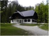 5
5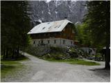 6
6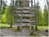 7
7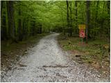 8
8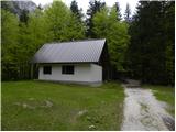 9
9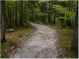 10
10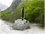 11
11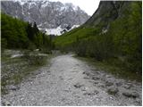 12
12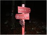 13
13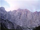 14
14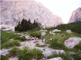 15
15 16
16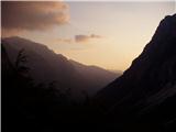 17
17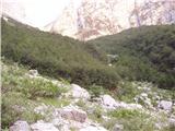 18
18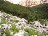 19
19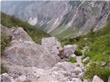 20
20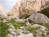 21
21 22
22 23
23 24
24 25
25 26
26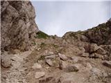 27
27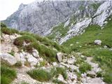 28
28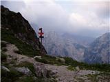 29
29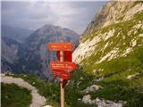 30
30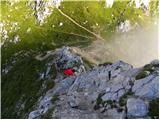 31
31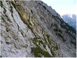 32
32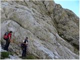 33
33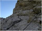 34
34 35
35 36
36 37
37 38
38 39
39 40
40 41
41 42
42 43
43 44
44 45
45 46
46 47
47 48
48 49
49 50
50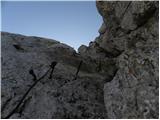 51
51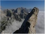 52
52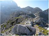 53
53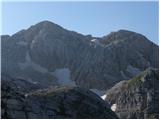 54
54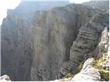 55
55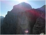 56
56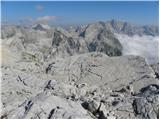 57
57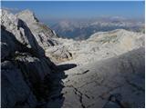 58
58 59
59 60
60 61
61 62
62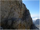 63
63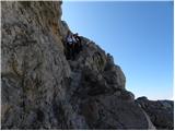 64
64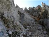 65
65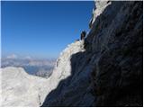 66
66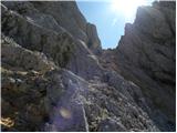 67
67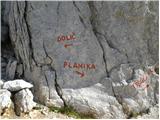 68
68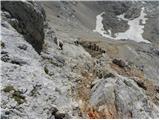 69
69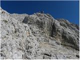 70
70 71
71 72
72 73
73
Discussion about the trip Aljažev dom v Vratih - Triglav (via Plemenice)
Show older messages
|
| Gost29. 07. 2007 |
The sign at Aljažev dom indicates 7 hours for this route.
|
|
|
|
| Gost29. 07. 2007 |
The self-belay kit is, at least in my opinion, extra baggage on this route, as it's only useful rarely along the entire path (entry section and chimney below Plemenice) and anyone who thinks they can't manage without 'via ferrata' gear, I recommend they don't attempt it.
Safe steps in the mountains
|
|
|
|
| Gost16. 08. 2007 |
This is quite a messed-up trail. It's okay going up, but I definitely don't recommend it for going down. Especially because due to friable rocks, pegs are almost always missing or slings are torn. I went down there yesterday and it was quite critical at some spots.
|
|
|
|
| Gost26. 08. 2007 |
If you go down through Plemenice it's really tough because the cables are torn in places and everything is crumbling....
|
|
|
|
| Gost26. 08. 2007 |
Can someone from the two previous posters explain why he went DOWN through Plemenice.
Because, at least in my opinion, there are much friendlier descents, whether starting from Vratih or Trenti.
But some of you are just Jakci (not Jacki - no typo)...
Why do you complain on forums then. Or is it (like) self-praise?
Good luck and safe steps
|
|
|
|
| Gost27. 08. 2007 |
Since we plan to take this route to Triglav, please provide a realistic comparison of the route's difficulty with e.g. the ridge route to Prisojnik. Especially how it is on that narrow ledge without protections and the initial section from Luknja. Thanks.
|
|
|
|
| Gost5. 09. 2007 |
The path through Plamenice is really nice. Of course not for those with vertigo or fear of heights, because sometimes you have to climb a bit, step on a peg, hold on somewhere etc. Serious climbing gear isn't necessary in my opinion, but still be careful. Personally I wouldn't go down this path, much nicer to descend via Prag.
So, for anyone not afraid of heights, not exactly a beginner in the mountains, I warmly recommend the Plamenice path. Of course when I say no gear needed, I still mean proper mountain boots are obligatory, and not just go up in jeans. Just normal high-mountain gear.
regards
|
|
|
|
| Gost6. 09. 2007 |
What does "warmly recommend" mean? Miha
|
|
|
|
| Gost10. 09. 2007 |
"Toplo priporočam" is an expression that means I highly recommend something to you, that I myself was very satisfied with this thing and recommend to others to experience it too.
Anything else you're interested in, Miha????
|
|
|
|
| NEIC00817. 09. 2007 |
Why are there no pictures??? No brave ones to take some?? 
|
|
|
|
| Gost17. 09. 2007 |
The brave ones are there, they just use their hands for something else than photographing this path. Read for example NEIC008 some description in a good guidebook and everything will be clear to you. Good luck!
|
|
|
|
| Gost20. 09. 2007 |
Hello,
I'm interested in the condition of this path, especially the grip (how far the snow goes and if it's slippery)
We plan to go this weekend.
|
|
|
|
| Gost20. 09. 2007 |
There is snow in the high mountains. Otherwise, ask at Kredarica. I think that's just the right place for this information. Good luck!
|
|
|
|
| jersy21. 09. 2007 |
ooh when will there be pictures of this path
|
|
|
|
| velijo8. 10. 2007 |
I hiked this trail a year ago, I have more pictures but don't know how to upload them. It's true that it's not easy to take photos right above Luknja, but still I have a few good ones.
To me the fixed cables didn't seem torn, although I don't know if last year's snow damaged them. For me the trail is really wonderful. The view of the North Face and Sfinxa is top class.
I don't dare advise against helmet and via ferrata kit, although I think they are needed only for about 10 min above Luknja and maybe after entering the climbing trail below Triglav due to many people on the path.
Descent via Plemenice I advise against
|
|
|
|
| Gost14. 11. 2007 |
Here are pictures from the Plemenice trail. There are still some brave ones among us who dare to take photos. The trail through Plemenice is one of the most beautiful in our mountains. Tadeja
|
|
|
|
| Gost14. 11. 2007 |
Where are the pictures supposed to be?
|
|
|
|
| Gost14. 11. 2007 |
I was up there through Plemenice many years ago. That was my first such secured trail. I was quite scared at the beginning, right above Luknja. Later it wasn't so bad anymore. But the trail is very beautiful with views towards Trenta, later also towards Sfinga and očak.
|
|
|
|
| Gost11. 12. 2007 |
I sent the pictures to the above email if it helps. It was taken on 21 September. But I must say, the path in ice and snow is X times harder than on dry ground! So be sensible, as it's really exposed in places and unsecured, self-belaying doesn't help much there. It can already take time and you'll be late up top.
Best, Matija
|
|
|
|
| Gost11. 12. 2007 |
Eh, didn't send the pictures, some error message comes back....
|
|
|
|
| Fazo24. 02. 2008 |
What cool photos! Really nice! I was there through the hole about 2 years ago up. The path is really nice, with a lot of exposed sections, and you can see it's in Gorenjska, because some peg would come in handy somewhere...especially on that boulder you have to hug, and it's not small (there was the only crisis, and I'm not exactly brave when it comes to heights ) )
Have a nice time and stay safe and lucky!
|
|
|
|
| SPIDER25. 02. 2008 |
I won't act smart. Just for information, Plemenice are on the Primorska side.
|
|
|
|
| Fazo25. 02. 2008 |
ok, you're right...but it has a bit of Gorenjska flair
|
|
|
|
| SPIDER25. 02. 2008 |
If I'm not mistaken, the Plemenice trail is maintained by PD Bovec markers, and they were already doing some maintenance last year, or rather a landslide in Slovenska on Mangart overtook them. Otherwise, Plemenice must be a bit adrenaline-packed since that's what they're known for.
|
|
|
|
| triglavski27. 02. 2008 |
The path through Plemenice is maintained by PD Ptuj.
|
|
|
|
| fpetel119. 08. 2008 |
Yesterday I did the mentioned path. With my buddy we needed a bit more than 6 hours. The path is mainly physically demanding and therefore harder than other approaches. I wouldn't recommend it for descent, because there is quite a bit of climbing (not too steep) on rocky terrain above cliffs without protection.
|
|
|
|
| nod3226. 07. 2009 |
I wonder if I need an ice axe for the ascent?
best regards
|
|
|
|
| jusuf18. 08. 2009 |
For those planning to "tick off" Triglav in one day, the path through Plemenice (or Bambergova pot) is very suitable UPWARDS. I recommend starting from Aljažev dom very early (end of August at 4:00) with a headlamp. The path to Luknja (2 hours) is not demanding and when you enter the ridge of the north face, dawn breaks. From the path there is a magnificent view of the north Triglav wall. Otherwise it is demanding and not for the vertiginous, but no protection is needed. A helmet is almost mandatory. Down, of course, via Prag or Tominškova.
|
|
|
|
| zlatorog31. 08. 2009 |
The day after the rain is always the most beautiful, and it was the same yesterday. Ascent via Plemenice to Triglav, descent to Kredarica and then via Prag to Vrata. Wonderful weather and no crowds.
|
|
|
|
| Stric2. 09. 2009 |
I advise against descending this trail, but if you do, I recommend mandatory additional protection, unless you enjoy sheer adrenaline and excellent views of the cliffs. Good luck!
|
|
|
|
| velkavrh4. 09. 2009 |
Today I checked Bojan A's contribution and it really impressed me. Not everyone makes such high-quality, even professional, contributions supported by wonderful photos. Worth praising!
|
|
|
|
| rokkk20. 09. 2009 |
I recommend traversing this path one week before the start of September because there's not much crowding
the path to the hole misleads you a bit because it drags on and the rest of the path is quite circuitous, I don't recommend it for descent at all if you're only hiking one day, likewise I don't recommend Tominškova path for descent
regarding belaying it's fine, no need for self-belaying, but I warmly recommend a helmet
7h at Aljažev dom is probably an exaggeration
|
|
|
|
| al128. 09. 2009 |
Hi! I'm interested in how it is crossing the snowfield from the Plemenice-Triglav direction. Are crampons needed? LP
|
|
|
|
| jersy28. 09. 2009 |
the snowfield can be crossed quite normally without any winter gear! Lp
|
|
|
|
| al128. 09. 2009 |
Thanks for the reply - there will be 1 kg less in the backpack.
|
|
|
|
| Klemn1a24. 02. 2010 |
Hello,
I'm interested if the path through Plamenice under Triglav joins the path that comes from Doliča (at the end of the scree under Triglav Notch) or goes directly from Plamenice to Triglav? 
lp
|
|
|
|
| Murglovc24. 02. 2010 |
There is no direct path from Plemenice to the summit. As you already wrote, it joins the path from Dolič.
|
|
|
|
| turbo25. 02. 2010 |
From Plemenice there is another path to Triglav summit. Namely via Kugy shelf to Triglav glacier, then to Kredarica-Triglav path and to the summit. Kugy shelf is marked with some marks and a bit secured with wire (both done by Žakelj, who has a bivouac in the bunker besides Morbegna). This path is not an "official" hiking path, it's demanding, don't go on it if there's still snow and appropriate experience is needed. Considering all that, it's a nice addition to the ascent to Triglav.
|
|
|
|
| sPolonca7. 07. 2010 |
The path downhill in this direction is really a bit wild, but since I like climbing: fine. Next time I'll definitely prefer this path upwards. Especially thinking of some foreigners who were either trembling or crying. Mostly helpless. With proper gear or without. Strange there aren't more accidents in our mountains than there already are.
For those who don't know the path, the awkward snowfield is soon after the junction to Dolič. I followed footprints in the snow to find the marks. Good thing the sun didn't melt them.
|
|
|
|
| jusuf8. 07. 2010 |
This path is really more pleasant upwards than downwards.
And it's not only foreigners getting lost in the mountains. Two years ago on the path through Plemenice in the wall about 200 m above Luknja at around 6:00 a.m. I found a group of frozen and even more frightened Styrians who had bivouacked there after descending from Triglav and heading to Dolič, but got lost somewhere on Podi.
In the last two days two fatal accidents in the mountains! More or less due to ignorance and carelessness.
Tragic.
|
|
|
|
| nisa2. 08. 2010 |
On Saturday I completed the route from Aljažev dom to Luknja and then via Plemenice to Triglav.
No problems through Plemenice, no crowds, no snow, great views. All good up to Triglavska škrbina. From there new snow to the summit. Very slippery in places without fixed protection, need to find holds under the snow, in short unpleasant.
From the summit to Kredarica some wet rocks, but nothing special, then descent via Prag. If I had known about so much new snow
I would have postponed the trip. Hope the snow melts by Sunday and Monday. Otherwise, a very nice day trip.
Best regards!
|
|
|
|
| svizec617. 10. 2010 |
Three years ago due to lack of time I only did part of the path to Triglav via Plemenice, namely to the top of Plemenice and then back the same path to Aljažev dom. The path via Plemenice downhill is really somewhat demanding, especially orientation in the lower part above Luknja. But one needs to stay well focused all the way to Luknja. I was surprised because I met quite a few hikers (also older ones and foreigners) who used the path through Plemenice for descent from Triglav. To me, a helmet is mandatory for the path through Plemenice, via ferrata kit optional.
|
|
|
|
| ŠpRo2919. 07. 2011 |
Question? Can this path be compared at all to Tominškova? How is the condition on this path these days? Plan is to go end of August or beginning of September, and I'm interested since there's no comment since last October, if there's anything special to watch out for. Thanks in advance for answers.
|
|
|
|
| andrej7819. 07. 2011 |
This path is much more demanding than Tominškova, viewed from technical aspect, orientation and fitness. But it's very beautiful and has stunning views to the Primorska side and into Vrata. Walking on top of Sfinga is a unique experience.
|
|
|
|
| velkavrh19. 07. 2011 |
Within two weeks I'll go to Triglav via this path. If anyone wants to join me, contact me via private message. Starting from Kranj and can even pick someone up by car-no problem, anywhere on the way to Vrata. L.P.
|
|
|
|
| antik27. 07. 2011 |
Planning to "do" Triglav in one day, 30.07., on Saturday, up through Plemenice down through Prag, starting from Aljažev dom very early (at 5.00). Wondering if it's possible to get breakfast (fried eggs) at Aljažev dom that early, at 4.30?
|
|
|
|
| nata2427. 07. 2011 |
Call 04/589-51-00 or 031/384-011 and ask.
|
|
|
|
| gj27. 07. 2011 |
you're just kidding. take boiled ones with you
|
|
|
|
| antik27. 07. 2011 |
hahaha, I'll definitely take eggs with me cuz I'll need them, cuz it's my first time through Plemenice.
|
|
|
|
| dore27. 07. 2011 |
I think you'll need long pants more...
|
|
|
|
| janez483. 08. 2011 |
I'm wondering if there's any water on this path?
|
|
|
|
| nata243. 08. 2011 |
Snow for sure, if warm then consequently some water too 
|
|
|
|
| bilja3. 08. 2011 |
If you can squeeze it out of some crevice 
|
|
|
|
| anamis11. 08. 2011 |
I was a brave beginner who went in one day through the window to Plemenice and later little window to Razor and down to Zadnjice valley. =) It was the best and most beautiful experience I could get in the mountains, pictures are here:
http://francistapon.com/Travels/Eastern-Europe/The-World-s-Most-Dangerous-and-Extreme-Backpacking
Anyway, I have to say that pictures are not comparable to reality. I went with a pro in my opinion, but I think that won't really help you there hehe.
And Triglav via Plemenice I did the day before. And it's nothing in comparison. I mean, it's quite easy and I'm no climber or anything.
As for water @Janez48 you'll find VERY LITTLE water in these hills, down I know, right before you start climbing there's a stream, drink a liter there for sure and one liter before the car... the mistake people make is saving water, while your joints and body need to be well hydrated from the start.. and then take one or two liters with you and sip them along the way =) In my opinion this is one of the big mistakes people make - saving water and then they're totally done and various injuries... And also because it's not really hot, you don't realize how much water you lose.
|
|
|
|
| JUREE11. 08. 2011 |
Really brave, but you mistyped a bit, you went through the window to Prisojnik.
|
|
|
|
| anamis11. 08. 2011 |
Hahahah that's true =D Thanks!!
|
|
|
|
| HMatjaž12. 08. 2011 |
Yesterday went through, visibility SUPER simply a pure 10.
|
|
|
|
| Grand12316. 08. 2011 |
I recommend up through Plemenice back through Prah - excellent view and high chance to see chamois...
|
|
|
|
| urbancek25. 08. 2011 |
Is there anywhere so exposed that self-protection is essential? So I don't drag it with me for nothing? Thanks for reply!
|
|
|
|
| turbo25. 08. 2011 |
Urbancek,
there is nothing ESSENTIAL in the mountains! (except maybe fleeing from a thunderstorm  ) )
And often (me too!) it's good to carry something unnecessary with you!
Plemenice is after all the most demanding marked trail to Triglav, if that tells you anything
|
|
|
|
| urbancek25. 08. 2011 |
I agree...
But still I can ask for advice... Surely someone has already gone up there and can tell, because from what I've read so far I'm confused... After all, hribi.net is there to help someone make a decision, isn't it?
|
|
|
|
| urbancek25. 08. 2011 |
For example, last time on Prisanka via Kopiščarjeva and Jubilejna I clipped in about 5 times on the whole route...
From these photos in the description, there's nowhere like being on pegs and brackets in a smooth wall 10-20m high, where there's NO other grip in case of lowering the cable etc... I'm interested if there's such terrain without direct drop into the abyss...
|
|
|
|
| urbancek25. 08. 2011 |
Please, don't just moralize to me, because I have quite some experience in the mountains... And every time someone asks something, you start moralizing as if to some beginner who previously walked on Rožnik... In July and August I already have about 20 two-thousanders behind me...
|
|
|
|
| turbo25. 08. 2011 |
Urbancek,
experience is exactly that, knowing what to take with you. And no, I'm not moralizing.
Last time on Plemenice I didn't have a self-belay kit (two years ago). And that's because I started up from Luknja at night with a headlamp, the "wall" was empty, no one anywhere...
E.g. this year, about a month ago, I had self-protection and clipped in on Hanzova to M. Mojstrovka exclusively because of the crowd (avoiding others, overtaking, dislodging rocks due to crowd, etc.) That's about it
|
|
|
|
| urbancek25. 08. 2011 |
And for that information so many empty words and rubbish??! Of course I found out what I wanted, thanks! Maybe I asked incomprehensibly, I don't know...
|
|
|
|
| urbancek25. 08. 2011 |
Well look, how can I have experience for this path if I haven't walked it yet... I don't have those...
|
|
|
|
| turbo25. 08. 2011 |
Empty words, rubbish?
When I go somewhere for the first time, I take everything with me, when repeating also less.
Million photos from Plemenice on the net, million descriptions too, so you compare paths you've walked with descriptions and photos of the path you're heading to. Then it's your thing whether you go "on the safe side", i.e. equipped or
|
|
|
|
| turbo25. 08. 2011 |
Urbancek writes (ZS):
"What are you rushing? Don't be smart and don't post nonsense... I don't need any more information from you on this forum, clear? We've concluded, I hope..."
But he got a perfectly useful answer, so it doesn't help him
|
|
|
|
| urbancek25. 08. 2011 |
Exactly so, I don't know what you want from me (posting another post here again), I don't want anything from you anymore...
|
|
|
|
| urbancek25. 08. 2011 |
Why could user kucelj nicely write his opinion, without arguing and moralizing? And it was all nice and right... But to be silent to such a moralizer, no I won't...
|
|
|
|
| urbancek25. 08. 2011 |
But don't forget that you insulted me at the end too... Anyone can read who nicely and friendly asked at the beginning and who started provoking him afterwards...
|
|
|
|
| VanSims25. 08. 2011 |
Turbo can indeed be quite a good provoker (see e.g. the thread "Where with the dog?") and posting private messages on the forum isn't exactly proper, that was already one of the scandals on this portal.
On the other hand, urbancek, one can see who exactly has cluttered so many and so many posts and empty words under this post, right?
|
|
|
|
| urbancek26. 08. 2011 |
It's true and I'm sorry, administrator please delete this nonsense... Then zs-ji came to mind, and user turbo played them to everyone...
Anyway, today I did the following tour: Vrata - Luknja - Plemenice - Triglav - Planika - Kredarica - Rž - Stanič - Visoka Vrbanova špica - Stanič - Begunjski vrh - Stanič - Vrata (through prag). 9h 15min (everything included in this time)
For the starting part of Plemenice I recommend self-belaying. But really, that's it and later there are no such dangerous sections of the path.
Best regards!
|
|
|
|
| Flora126. 08. 2011 |
Good job, you're really fast. 
|
|
|
|
| Luki27. 08. 2011 |
I'm interested in a comparison of the paths to Triglav via Plemenice and Tominškova pot. Which one is easier?
|
|
|
|
| Luki27. 08. 2011 |
And how do these two paths compare to the path to Jalovec via Kotovo sedlo? Especially regarding exposure and difficulty of the climbing sections.
|
|
|
|
| ljubitelj gora28. 08. 2011 |
Today I took this path, photos are on the portal under 28.8.2011.
|
|
|
|
| svizec629. 08. 2011 |
The path via Plemenice to Triglav and via Kotovo sedlo to Jalovec are very similar in difficulty and length - good fitness is needed, even if you go for two days. Tominškova to Triglav is a bit easier, as there are two huts on the way to the summit if you get tired in between. But it's not suitable for those afraid of heights, although it's quite well secured.
LP
|
|
|
|
| zmaJ25. 09. 2011 |
Yesterday, 24.9. my colleague and I went to Triglav via Plemenice, and I must say, the path except that it's a bit longer is not demanding at all. Self-belay is not needed, helmet of course everywhere. It's not exposed much either, we descended via Praga. I don't know why people exaggerate with the difficulty rating.
|
|
|
|
| lepenatka25. 09. 2011 |
When you go on this path for the first time, a harness at least in the backpack is not superfluous.
Everyone probably rates the difficulty differently.
This path didn't present difficulties to me, but it's the most beautiful of the approaches under Triglav.
|
|
|
|
| goba122. 10. 2011 |
hiked the route 28.10.2011... the route is wonderful but the weather was a problem (fog and possible winds from Vrata). The route itself is demanding but for a mountaineer with just some experience it's a fairytale Self-belaying gear is not mandatory, helmet is!!
|
|
|
|
| ahimcemovik19. 07. 2012 |
This path is really super, if you're not afraid of some exposed sections it's also suitable for the return.
|
|
|
|
| urbancek19. 07. 2012 |
Yes, but you have to be extremely careful not to dislodge rocks... If there's a crowd or even two-way traffic it's quickly dangerous that something gets triggered... Best regards!
|
|
|
|
| Janez Kastrevc19. 07. 2013 |
I'm interested how it is through Plemenice, has anyone been up recently? As far as I know the trail is dry, except at ZTP, apparently there's still snow there.? Are crampons needed? Or is an ice axe enough?
|
|
|
|
| ms_primoz19. 07. 2013 |
And does anyone know if they chase you away if you spend one night in the car at the parking lot (Aljažev dom v Vratih)?
|
|
|
|
| jedriličar19. 07. 2013 |
Slept there multiple times, no problems at all...
I don't know why anyone would chase you away?
You arrive in the evening, sleep over, and tomorrow up... anyway they start arriving by cars at 4-5 and you can't sleep anymore...
|
|
|
|
| Alesko197119. 07. 2013 |
There are things you don't ask out loud. You'll trigger two things:
1. in Vratih a sleeping settlement will emerge, since they say on the forum that it's possible...
2. you'll attract a bunch of newly baked customs inspectors who now bother everywhere, everyone, and for anything... Brave New World
If you intend to sleep over, do it, if not, don't.
No one can give you official blessing.
|
|
|
|
| VanSims19. 07. 2013 |
They bother only in Slovenia, abroad (north and west of course) there's no problem at all, except in rare places where it's prohibited.
|
|
|
|
| jeklenica1622. 07. 2013 |
Are crampons or ice axe needed on the path through Plemenice to Triglav? Is there still snow?
|
|
|
|
| idesh22. 07. 2013 |
winter equipment not needed
|
|
|
|
| katja8729. 07. 2013 |
On Saturday, 27.7.2013, we headed to Triglav via Plemenice.
We did the tour: Vrata - Luknja - Triglav (via Plemenice) - Kredarica (via Mali Triglav) - Dom Valentina Staniča (via Rž).
The path via Plemenice is really great and at times adrenaline-pumping due to its variety We had self-belaying kits with us, as safety comes first.
The most beautiful part is when you can get very close to the face of the Sfinga and enjoy a magnificent view of the sheer wall below it
Snow needs to be crossed only over the Zahodna Triglavska planota, but winter gear is not necessary.
Pictures from the hike can be viewed on the website of Planinsko društvo Matica Murska Sobota: http://www.mojalbum.com/pdmaticams/20130727-triglav-cez-plemenice/aljazev-dom-v-vratih-v-objemu-severne-triglavske-stene/20959555
|
|
|
|
| AndrejRibic29. 07. 2013 |
Very nice photos, I must praise the author of the pictures. Personally, I haven't been on this path yet. I have been on Tominškova. Are Plemenice comparable to Tominškova? Thanks in advance for the answer. Team, keep it up.
|
|
|
|
| ljubitelj gora30. 07. 2013 |
I went via Tominškova and twice via Plemenice. Plemenice are considered the most difficult secured path to Triglav and are harder than Tominškova.
|
|
|
|
| ms_primoz30. 07. 2013 |
what is harder, Dolgi hrbet or Plemenice?
|
|
|
|
| andrej7830. 07. 2013 |
Relatively, I think Plemenice due to the length and exposure.
|
|
|
|
| John30. 07. 2013 |
I don't have practical experience with Plemenice yet, but judging by the photos, Plemenice are more "vertical" and exposed, Dolgi hrbet is also endless to grab with the left hand, it just doesn't end. Especially in the scorching heat.
|
|
|
|
| ms_primoz30. 07. 2013 |
John - I felt that on Saturday...
|
|
|
|
| Domch31. 07. 2013 |
ms primoz - you can absolutely go via Plamenice, if you have done Mrzla gora, Škrlatica, Tominškovi, Dolgi hrbet, Križ,... then no fear it would be too difficult, fitness is there too.
|
|
|
|
| ms_primoz31. 07. 2013 |
Domch - when are we going to Triglav via Plemenice?
|
|
|
|
| adamm31. 07. 2013 |
I plan in September (4.09) to Triglav. Coming from Poland. Overnight in Mojstrana and morning start mountain path from Aljažev dom to Luknja then Plemenice. Again: Mali Triglav, Prag. Kindly ask for advice, what time at parking lot to return before night? Thanks LP
|
|
|
|
| Domch31. 07. 2013 |
Depends on fitness, but around 10 hours you can count, then calculate. ms Primož - we can go up together via Luknja then, I turn left to Bovški gamsovec and to Kriški podi. First need to survive Tominškovo, and some concrete secured paths, to consider Plemenice, definite wish sometime in future.
|
|
|
|
| Pero#243. 08. 2013 |
Hello,
where to descend if going to Triglav via Plemenice?
|
|
|
|
| tisa3. 08. 2013 |
There are more options, one is past Kredarica and along the path over Prag to Vrata. Also possible past the hut at Dolič and from there over Luknja back to Vrata.
Good luck!
|
|
|
|
| mirank3. 08. 2013 |
Pero, depends where you started and where you plan to end. If you started in Vrata return over Prag. If you started in Trenta then over Dolič. I strongly advise against the last variant from Tisa (past Dolič and over Luknja), because you'll lose approx. 200m elevation which on return is a real nightmare when ascending back to Luknja
|
|
|
|
| Pero#243. 08. 2013 |
Thanks for the answers. LP
|
|
|
|
| zinka13. 08. 2013 |
I'm wondering whether the fixed protections on the path through Plemenice are in good condition or not. Thanks.
|
|
|
|
| 75'er20. 08. 2013 |
Zinka, if it's not too late, about 3 weeks ago they were completely fine.
|
|
|
|
| zinka24. 08. 2013 |
It's really too late, but thanks anyway. I went and convinced myself.
|
|
|
|
| smatjaz24. 08. 2013 |
zaqi, great photos!!!
Does anyone know if the path through Plemenice is comparable to the path from the glacier below Skuta (Ledin) through Jezersko sedlo to Koroška Rinka? Thanks
|
|
|
|
| Macesna24. 08. 2013 |
Not comparable. Through Plemenice is in my opinion much harder: it's longer, more sparsely protected, sometimes you have to look carefully to find the continuation of the path. But it's not crumbly like to Koroška Rinka (via Kamniška pač).
|
|
|
|
| smatjaz24. 08. 2013 |
Macesna, thanks for the reply, I won't go up there, as I already got weak knees on Rinka in the section without cables.
|
|
|
|
| BibaS26. 08. 2013 |
zagi, really nice photos!
|
|
|
|
| mukl16. 09. 2013 |
Zagi, fantastic photos, it really tempted me to go this year too, although it will probably, unfortunately, have to wait until next year...
|
|
|
|
| MaxSi18. 10. 2013 |
Yesterday I did the tour Vrata-Luknja-via Plemenice-Triglav-Kredarica-Tominškova path-Vrata.
I allowed myself an earlier start and thus reached the climbing section of the path via Plemenice still in complete darkness. Although I knew there was some snow in the high mountains, I was surprised by how much there was on this path, so halfway through the climbing section I had to put on crampons and take the ice axe. I can say it's really well covered with snow in places, plus it was all frozen in the morning, turning the hike into a real little alpinistic-adrenaline adventure.
The path past Sfinga is almost flat, but walking on wind-packed snow is quite demanding, as each step alternates between ice plates and sinking to the waist, as evidenced by today's bruises all over my body. The first part of the ascent to the notch summit is demanding, as pitons, cables and pegs are hidden under snow, and the path appeared untrodden. Up to the sunny section (when we see the summit) the path is extremely demanding and fully winter climbing, then it eases a bit towards the top. Only the strong gusts of wind and iced cables full of rime were somewhat annoying. I don't remember ever expending so much energy just to reach the summit.
Followed by descent to Kredarica. In this direction the path is somewhat easier, as it's tracked and the snow was a bit softer, providing a somewhat more pleasant step. As usual, the final descent to Kredarica is extremely demanding, requiring 100% concentration and caution.
At Kredarica we briefly discussed current conditions, so if you're heading out, here's a bit about it. From Krma to Kredarica currently only little snow, about 100-200m below Kredarica, it's soft and for the approach you need nothing but poles and suitable footwear. Completely different story from Vrata side, where snow starts at the junction of the path via Prag and Tominškova. The path can be quite icy, as most of the morning it's in shade, sinks in places. Definitely recommend only to more experienced with proper gear. At least simpler crampons (those that slip on shoes) and poles advisable.
Tominškova path at the top can be icy in places, some snow patches. Caution not amiss, but nothing extreme.
In conclusion, it's winter in the high mountains, so only experienced and well-equipped hikers should attempt such approaches.
Happy trails everyone.
|
|
|
|
| kardizume14. 07. 2014 |
Hi. What are the conditions on the path like? Has anyone been there yet?
Thanks for the reply.
|
|
|
|
| ms_primoz8. 08. 2014 |
Does anyone know if the path can be walked without winter gear?
|
|
|
|
| ms_primoz8. 08. 2014 |
Does anyone know if the path can be walked without winter gear?
|
|
|
|
| živa sraka9. 08. 2014 |
Yes, I walked it on 8.8.14 without crampons and ice axe, but I had SVK, which I didn't even use because I managed well without it. When the weather is nice, go boldly on the path
|
|
|
|
| kitta26. 10. 2014 |
Hello,
I'm interested whether the path through Plemenice is passable or if there is a lot of snow.
|
|
|
|
| redbull26. 10. 2014 |
not much snow,, it's trodden,, checked,, a bit more caution, as it can be icy,,, also in the Bovška škrbina, as in my opinion you don't need crampons, ice axe recommended,
best regards
Dejan
|
|
|
|
| lizika26. 10. 2014 |
Bulči, back to your senses, right?
|
|
|
|
| redbull26. 10. 2014 |
I'm not in the stable like you,, but on the terrain,, go to sleep instead, they've already tucked you in
|
|
|
|
| lepenatka27. 10. 2014 |
Redbull,
you seem like such a nice guy. I'm glad you have such a love for the mountains, I gladly and regularly read your path descriptions and extreme achievements. Really, bravo! But such disrespectful writing really suits you. Sorry.
Many have stopped actively participating on this portal precisely because of such (not only yours) comments.
I wish you lots of enjoyment in the mountains.
|
|
|
|
| redbull27. 10. 2014 |
I know it's not nice,, I know it all too well,, but when reading about every summit, those who have no idea interfere-- here it's only about that vixen. Regarding her, I will never change my opinion, unfortunately
|
|
|
|
| ms_primoz27. 10. 2014 |
yeah redbull you stick your nose into everything, because you probably know the most (or think you do)... this portal can be called REDBULL.net. Because only you and your ten have nothing better to do than fill ego on the portal. so bravo... applause, you're really great... bravo
|
|
|
|
| redbull27. 10. 2014 |
what is asked and if I know I answer,, what I don't know I don't comment.. EASY you provoke, it doesn't move me. I put you in the same basket as chuppa chups, so I don't worry.
best regards
|
|
|
|
| ms_primoz27. 10. 2014 |
to your highness... you're really great...
|
|
|
|
| redbull27. 10. 2014 |
thanks, nice to hear. You're great too.
|
|
|
|
| mukl28. 10. 2014 |
Admin, it would be great if you deleted comments that have nothing to do with the path, thanks. Mine also belongs to this group, so no mistake...
|
|
|
|
| zupi10. 03. 2015 |
I'm interested if the path via Plemenice is comparable to the Tominšek route to Triglav? Or is it more demanding? Thanks
|
|
|
|
| Smetar10. 03. 2015 |
The Bamberg path via Plemenice is (slightly) harder compared to the Tominšek path.
Check out this video: https://www.youtube.com/watch?v=21y8D36trKI .
If you're going to Triglav for the first time and have no experience, I don't recommend this path...
|
|
|
|
| darinka411. 03. 2015 |
I go via Plemenice from Zadnjica several times in summer. It's good if you have some climbing experience, and above all good fitness.
|
|
|
|
| zupi11. 03. 2015 |
Thanks Smetar and darinka4. I already have some experience, this year it's my fifth time to Triglav, just haven't gone via Plemenice yet. I'll try it, back via Prag
|
|
|
|
| darinka411. 03. 2015 |
Don't forget the helmet. Maybe a via ferrata kit, some take it, I don't. All harder parts are well secured, so no panic. And have a pleasant ascent via Plemenice when the snow melts.
|
|
|
|
| ms_primoz11. 03. 2015 |
that's exactly why, because they are well secured - the SVK (via ferrata kit) comes into play... or maybe you use SVK for example for Mrzla gora, where there are no fixed cables anyway...?
anyway, if the path via Plemenice were in Austria - no one would talk about SVK (because it's self-evident there). And I'm not a fan of SVK. nice day
|
|
|
|
| darinka411. 03. 2015 |
Yes, I use it, e.g. Hanzova on Prisojnik. Also on Rinke, I had it, then via the north face to Montaž and to Viš gola nordest as well as Karnijske ..via ferratas, if you ever go on the climbing route to Colians, the via ferrata kit will come in very handy there. Good luck on the trails....
|
|
|
|
| darinka411. 03. 2015 |
it comes in very handy. And good luck wherever the trail takes you
|
|
|
|
| alyas23. 07. 2015 |
Bamberg path from Luknja via Plemenice - direction markers renewed and clearly visible, all protections OK. If you reach Luknja from Vrata by 8 a.m., in summer heat you'll be in shade practically all morning up to the West Triglav wall or Triglav saddle. And if you want to look the Sphinx in the eye, here's a great chance,... views on this approach are truly imposing - magnificent. Snow on ledges and below wall almost gone even for refreshment.
Of course not for beginners, exposure at start means SVK useful even for average hikers, plus another demanding section mid-way.
|
|
|
|
| Domch23. 07. 2015 |
Besides, we must not forget that it is a very demanding fitness hike (one-day trip). You can count on at least 8 hours of pure walking, plus a lot of gear in the backpack. In the end, the beauties of this path outweigh everything; for me personally, the most beautiful ascent to the summit of Triglav.
|
|
|
|
| Parkeljc23. 07. 2015 |
True, and from Luknja to ZTP you'll probably hardly meet anyone
|
|
|
|
| darinka423. 07. 2015 |
Just the other day I asked hikers who came from Vrata how long it took them to the Luknja pass. They said a bit more than two hours. I need about three hours from Zadnjica with a heavy backpack, since I usually go for two days, and there were some larger groups; they were well equipped, everyone had a self-belay kit besides a helmet, and they didn't dislodge even one pebble—climbing the wall was really pleasant.
|
|
|
|
| Parkeljc23. 07. 2015 |
True, and from Luknja to ZTP you'll probably hardly meet anyone
|
|
|
|
| JusAvgustin24. 07. 2015 |
I've descended via Plemenice many times. It drags on like the devil himself. But it's quite a fast descent. Down from Luknja though...
|
|
|
|
| Optimist00712. 09. 2015 |
Yesterday, 12. 9. 2015, circular tour Aljažev dom - Luknja - via Plamenice and Triglavska škrbina to the summit - Triglav. Then descent to Planika (tasty snack, I recommend Kranjska klobasa) - Kredarica and via Prag to the valley.
Just a warning - at the beginning of the path through Plamenice, after the first ascent, the cable is torn and the peg is driven into a "blind rock" which is wobbly. Higher up one peg is pulled out. I think the trail needs some renovation.
In the morning hours the rocks were slippery and even icy, also through Triglavska škrbina caution is needed, as some snow remains and it is trodden and "polished"
Good step!
|
|
|
|
| vmisurac27. 08. 2016 |
Do I need crampons and ice axe if I go over Plemenice to Triglav?
|
|
|
|
| redbull27. 08. 2016 |
No shortage of snow either, maybe some of yesterday's few cm remained
|
|
|
|
| mukica27. 08. 2016 |
Trail hiked yesterday, no major damage to fixed protections, just one piton pulled out and one cable torn.. no problem, not at critical points... You step into small snow patches twice which can cool you a bit, nothing else... my favorite trail to Triglav, especially less crowded than others
|
|
|
|
| milesdavis22. 09. 2016 |
With a legend to Triglav. Primorsko-Štajerska connection. 2 legends (brawler + Lojz)
link
|
|
|
|
| magroman5. 11. 2016 |
Yesterday 4.11.2016 three of us set out on this path. Probably caught this year's last "dry" ascent. Met less than 10 hikers. On the ascent, some small snow patches caused no problems. Descended to Kredarica. Icy in some places, great caution needed. To the valley via Prag, which was covered in snow up to cca. 1700 m, quite annoying descent. But conditions will be completely different today. Weather was great.
|
|
|
|
| redbull5. 11. 2016 |
Nice
It's time for Bamberg path to get snow-covered
Good luck
|
|
|
|
| magroman5. 11. 2016 |
You can hardly wait for the snow, right redbull?
|
|
|
|
| Domch6. 11. 2016 |
the snow will take care of it, just a matter of time, maybe this year, if not next year.
|
|
|
|
| redbull6. 11. 2016 |
, harder below zero
|
|
|
|
| Zzzmaaja27. 06. 2018 |
Hello! I already went along the Bamberg path last summer (access from Zadnjica), this weekend we would like to set off from Vrata and then continue along the mentioned path.. has anyone walked it recently? What are the conditions like? Best regards
|
|
|
|
| darinka427. 06. 2018 |
On 7.6. I walked there. There was some snow patches. They have probably melted by now. But there is snow on the western Triglav plateau. If it's soft, no problem. Triglavska škrbina is dry.
|
|
|
|
| spero17. 09. 2018 |
12.09.2018 second time on this route, 3 hours and 50 min to Triglav easily. No crowds and you fly like a chamois
|
|
|
|
| zbil10. 10. 2018 |
Hello!
How is the passability now that it has already snowed? Is the path still safe?
Please for a response from someone who has walked the path in the last week!
Thanks
|
|
|
|
| Zgembo16. 10. 2018 |
I was there on 13.10.2018, the path is nicely passable, there was only a sample of snow and you could nicely bypass it, a couple of cables are loosened and some peg sticks out, but it's normally passable. Nice tour.
Here are some shots
https://www.youtube.com/watch?v=s2zPb7M3T9Q
|
|
|
|
| zbil17. 10. 2018 |
OK, thanks for the reply and congratulations on the nice little video.
|
|
|
|
| vladika16. 08. 2019 |
Hello. I read and notice that the trail is very exposed and difficult. I have already been to Skrlatica, Mangart via the Slovenian route, up Tomiskova and down via Prag. I haven't had problems anywhere so far. I plan to return via Dolič and Luknja. I don't plan to return via Prag because the trail dragged on forever. I'd rather go down Tomiskova.
For the Vrata-Tomiskova-Triglav-Prag-Vrata route I took 10 hours. Is this trail longer? Is the Plemenice trail really that much harder? Tomorrow I'm heading out on this trail and will appreciate any response.
Safe steps, Vlado
|
|
|
|
| darinka416. 08. 2019 |
The initial section and the gully towards the top of Plemenice are harder, you need some strength there. Otherwise nothing more difficult.
|
|
|
|
| bbugari116. 08. 2019 |
Vladika, it is longer by about 1 hour for ascent and about 1.5 hours for descent because you gain elevation before Luknja (recommend quick descent via prag). Plemenice are as demanding as the Slovenian route on Mangart, the initial part even more. But nothing serious...
|
|
|
|
| vladika18. 08. 2019 |
@darinka4 and @bbugari1 thanks for the tips, you were right. It was insanely beautiful. Up through Plemenice and down Tominškova dol.
Started around 3 a.m., so at Luknja I waited a bit for dawn, then into the wall. The path is very demanding and quite long to Triglav summit. Weather at top sunny, fantastic. Could see Grossglockner, our peaks and outlines of our sea.
Really nice. Return past Kredarica and down Tominškova dol. Down Tominškova dol is even harder than up. Both paths well secured, here and there a peg pulled out, but nowhere at critical spots.
The path is really very nice and very demanding, so set out on it if you're fairly fit and have no fear of heights, and don't forget hat, gloves, helmet and good mood.
This my 10th ascent of Očak will stay long in my memory.
Safe steps, Vlado.
|
|
|
|
| cajer18. 09. 2019 |
Hello, I'm wondering if the path through Plemenice is mostly in shade during the morning or if the sun hits it quickly?
|
|
|
|
| cajer18. 09. 2019 |
In autumn weather and temperatures, say now, do you recommend ascent on this path based on experience?
|
|
|
|
| bbugari118. 09. 2019 |
In today's conditions: no snow, but wet. In such conditions only experienced mountaineers with proper gear (helmet, good boots, and also via ferrata set), and excellent fitness (strength in arms and legs)...
Tomorrow conditions are already different...
|
|
|
|
| epvlonhistria28. 10. 2019 |
I have already hiked it twice uphill, yesterday also in the opposite direction. For the descent, I experienced it differently, saw it with somewhat different eyes and only then truly enjoyed its exposure and steepness. Regarding self-belaying on this route, personally, I even advise against using SVK, because if someone can't manage it without self-belaying, it's better not to tackle it at all. Because there are very exposed sections where there is no possibility to clip in anywhere. However, 100% concentration and caution are required, because any possible mistake ends down on the scree. We three hiked yesterday from the summit to Aljaž quite slowly, covering it in six hours. And in doing so, we especially enjoyed the beautiful views of all Slovenian peaks, from Montaž all the way to the Kamnik Alps. We also spotted our local Učka somewhere in the south. Best regards from three Istrians, from Poreč.
|
|
|
|
| bbugari128. 10. 2019 |
Personally, I don't use SVK on Slovenian mountains, but this thesis that "if someone can't manage it without self-belaying, it's better not to tackle it at all" doesn't hold, because it means SVK is never needed. I will never recommend to other hikers on the forum to follow such a thesis.
Best regards from one Istrian.
|
|
|
|
| dprapr28. 10. 2019 |
Bojan, if you've already taken part of the sentence out of context, add the next sentence in the record...
|
|
|
|
| Enka28. 10. 2019 |
I don't know if you interpreted this correctly, bbugari1. I understood that on this specific route, besides the secured sections, there are also such that will cause severe problems to someone who can't manage past secured parts without clipping in. So this specific route might not be for me, but I can easily go to Mala Mojstrovka, where you can clip in on all problematic sections and there are no difficult spots that aren't secured.
|
|
|
|
| bbugari128. 10. 2019 |
I correctly interpreted the thesis that "regarding self-belaying" on Plemenice "advises against using SVK if someone can't manage without self-belaying". Logically (argumentum a contrario), this means that if someone can manage without self-belaying - is SVK then a necessary piece of equipment?!?!? So, there's no need to add anything to the quoted part of the sentence...
LP
|
|
|
|
| epvlonhistria28. 10. 2019 |
Hi my fellow Istrian. All OK. But now you're exaggerating a bit.
|
|
|
|
| Barentoter28. 10. 2019 |
@epvlonhistria, today you registered on hribi.net and you're already personally advising against SVK on a very demanding mountain route to Triglav. Really bravo!!!
Personally, you can climb in opanke because of me, if you can manage it
|
|
|
|
| epvlonhistria28. 10. 2019 |
And you can reach the summit by helicopter because of me.
|
|
|
|
| Domch28. 10. 2019 |
Self-belaying on this route can be used on three very well protected sections in between, but there are quite a few exposed parts that are not protected. We must not forget, however, the fact that the descent is usually done to Mali Triglav and Kredarica, where it is very well equipped for SMV use, and if you descend further via Tominškova, it can also be useful there, and for descent via Prag, Medvedova skala if needed. Everyone decides for themselves whether to use it, but it is recommended in all descriptions and I use it myself, especially when I do ascents alone, because then the view of the route becomes different than in a group.
|
|
|
|
| Tal25. 04. 2020 |
I'm interested in how the difficulty of the path compares to Tominšek's. Last year I went to Triglav via Tominšek and down through the threshold without any problems.
|
|
|
|
| Lunatixz26. 04. 2020 |
The path is significantly harder and much more exposed, and at the same time there are some sections that are not secured.
I suggest you watch some video on Youtube and then decide for yourself if you need to gain more experience - for example: https://youtu.be/lWLjl_kszEA
Best regards and good luck, M.
|
|
|
|
| fpetel126. 04. 2020 |
Personally, I didn't find the path that difficult. I've gone through Plemenice several times already. The path is mainly more strenuous than Tominškova and through Prag because it's at least an hour longer. Technically difficult mainly right above Luknja, where it's well protected and self-belaying is recommended. The continuation in some places towards Morbegna is not as well protected as we're used to on other approaches, but there's only one short unprotected and very exposed section that doesn't pose any special danger. Compared to the path to Jalovec from Tamar (both approaches), this path is better protected.
|
|
|
|
| dprapr26. 04. 2020 |
I fully agree with the last comment, except for the sentence "The path is mainly more strenuous than Tominškova and through Prag because it's at least an hour longer."
I've always reached Triglav faster and with less effort via this path (4 to 5 hours). Maybe because more of the path is in the shade.
|
|
|
|
| gj26. 04. 2020 |
Drapar, I agree, and you even gain fewer meters of elevation than on Tominškova.
|
|
|
|
| garmont26. 04. 2020 |
How fewer elevations, when it's the same starting point for both paths?
|
|
|
|
| bbugari126. 04. 2020 |
Only the secured part of the path?
|
|
|
|
| darinka426. 04. 2020 |
As already said. The initial part is demanding. And the chimney, which is quite higher up. There one cable is torn off, but it doesn't present a problem. Otherwise nothing more difficult.
|
|
|
|
| redbull26. 04. 2020 |
As Drago said. The timetable for Prag and Tominskova is considerably shorter than for Plemenice, but only on paper. In reality, and when you're on it, you only see that through Plemenice it's somehow similar, especially if you have a similar pace on both.
Good luck
|
|
|
|
| Turbolazec28. 06. 2020 |
Is winter gear still needed on this path?
|
|
|
|
| redbull29. 06. 2020 |
Plemenice dry, then further to Bovška škrbina there is still snow. Crampons necessary if the snow is too hard in the morning, ice axe mandatory!
|
|
|
|
| artur11. 08. 2020 |
Hiked yesterday.
Up through Luknja and Plemenice and down via Tominškova past Dom Valentina Staniča.
Can only praise the path through Plemenice, as it's well maintained, unlike Tominškova, where several sections need repair.
The rest about conditions is already in other posts.
Recommend the Locus Map app, which anyone can install for free on their smartphone.
Cheers
|
|
|
|
| Snecer13. 08. 2020 |
The path is well maintained, only one bolt for the cable has come loose in one section (in the last part). You don't need an app, because this path is exemplarily marked.
|
|
|
|
| Hribovc916. 09. 2020 |
The most beautiful and at the same time the most demanding secured path to Triglav. There is less protection than usual but because of that it is more pristine which gives it a special charm. For experienced hikers a very nice experience. The path after renovation is in very good condition. Descent via Prag.
|
|
|
|
| MinasTirith18. 07. 2021 15:07:34 |
Yesterday 17.7.2021 I set off along the mentioned path to Triglav.
From the valley at Aljažev dom in Vrata I started at 4:00 AM.
I reached Luknja around 6:00, no issues except scree towards the end which takes more energy.
Then I headed into the rocks where the climbing section begins. I must add that if you already have some climbing experience (previous feratas) and are physically fit (some sports activity in free time), the path is not demanding. I agree with comments and descriptions that the path is poorly secured in places and requires 100% caution throughout the climbing.
The weather was cloudy, windy (in open sections) and occasional raindrops. All the time it was visible that dark clouds were gathering higher up promising worsening conditions.
I continued the path towards Triglav knowing cold wet weather awaited me.
When I reached 2400m on open terrain, conditions worsened drastically (I didn't expect such changes). Wind gusts tossed me around literally (my weight with gear approx. 85kg). Visibility was so poor I could only see snow, some rocks ahead, but NO markers. I navigated using navigation loaded on my Garmin watch (navigation works excellently).
Since it was my first time on this path and I didn't know the exact direction, I decided to turn back and return the same way to the valley (turned back just before the junction with Kugyjerjeva pot).
Although watch navigation led me correctly, I didn't want to continue to Triglav as I didn't trust walking on snow (don't know terrain and frankly feared snow collapse into a hole).
Descent on climbing section despite rain and wet rocks didn't seem demanding or dangerous (shoes didn't slip). Caution needed!
Summarizing my findings:
- climbing section not demanding (if you have knowledge and experience),
- higher sections from 2300m onwards poorly marked,
- in poor weather not recommended for inexperienced climbers,
- so far definitely most interesting climbing path to Triglav summit,
- descent also interesting and fully feasible.
Lesson learned yesterday:
- No bad weather/conditions exist, only poor preparation of climbers/hikers.
Yesterday the mountain won the battle, but not the war
Best regards.
|
|
|
|
| Turbolazec20. 07. 2021 13:23:37 |
Hi! Are crampons needed for the path?
|
|
|
|
| G3424. 04. 2023 17:59:21 |
Is this path suitable for beginners? We've already done via ferrata Mojstrana. We plan to go to via ferrata Dobršnik and Hvadnik. Are we then prepared enough to go to Triglav via this path?
|
|
|
|
| potpodnoge25. 04. 2023 15:00:53 |
Minas, I only read your post today, but congratulations on the smart decision. The mountain will wait, accidents never! Safe travels on our beautiful mountains.
|
|
|
|
| Snecer2. 05. 2023 11:26:19 |
If you have already visited via ferratas, then the path through Plemenice is suitable.
Most do not use a safety kit. Good physical fitness is required (especially that).
Of course it all depends on the "mountaineer", what stuff he is made of. Even beginners vary greatly.
|
|
|
|
| ŠpRo292. 05. 2023 21:36:03 |
Walked this path some time ago, need to repeat it. Beautiful, airy and for a well physically prepared mountaineer. Regarding the self-belay kit, now it goes everywhere with me. Even if you are confident in yourself, you never know when a stone falls, when you slip, when you feel bad... There is some safety, that's my personal opinion. Everyone decides for themselves. Good luck, you will enjoy both the path and the views.
|
|
|
To post a comment you must log in:
If you do not yet have a username, you must first
register.