Bele vode / Rio Bianco - Rifugio Corsi (via Krniška škrbina)
Starting point: Bele vode / Rio Bianco (989 m)
Starting point Lat/Lon: 46.4096°N 13.5357°E 
Path name: via Krniška škrbina
Time of walking: 4 h
Difficulty: partly demanding marked way
Difficulty of skiing: no data
Altitude difference: 885 m
Altitude difference (by path): 1210 m
Map: Julijske Alpe - zahodni del 1:50.000
Access to starting point:
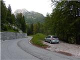
A) Over the border crossing Rateče we drive to Italy, and then we follow the main road to Trbiž / Tarvisio, where at the beginning of the settlement, we turn left in the direction of Bovec. The road after the settlement Rabelj / Cave del Predil quickly brings us to a crossroad at the lake Rabeljsko jezero / Lago di Predil, where we go right. Next follows some more of driving through the valley Jezerska dolina / Val Rio del Bianco, and then we get to the spot, where the road crosses the stream Beli potok / Rio Bianco, where on the left side we park on a smaller parking lot. About 100 meters ahead by the next stream there is a larger parking lot, where there is the starting point of the path on Jerebica.
B) Over the border crossing Predel we drive to Italy and we descend to the lake Rabeljsko jezero / Lago di Predil, where after the lake we continue left towards the mountain pass Nevejski preval (V Žlebeh) / Sella Nevea. Next follows some more of driving through the valley Jezerska dolina / Val Rio del Bianco, and then we get to the spot, where the road crosses the stream Beli potok / Rio Bianco, where on the left side we park on a smaller parking lot. About 100 meters ahead by the next stream there is a larger parking lot, where there is the starting point of the path on Jerebica.
Path description:
From the starting point, we first carefully cross the road, and then we continue on a marked path in the direction towards huts Brunner and Corsi and bivouac Gorizia. We at first walk on a gently sloping path which runs on the left bank of the stream Beli potok, and quickly the path becomes steeper, from the path which otherwise mostly runs through the forest, beautiful views opening up on boulders, rapids and pools of the stream Beli potok. Higher the forest gets thinner, so that a nice view opens up, which reaches from the nearby peaks, to the border mountains between Slovenia and Italy. Higher, we cross also few torrents, and then past a source we ascend to renovated mountain hut Brunner.
We bypass the cottage on the right side, and then we continue in the direction of bivouac Gorizia and mountain hut Corsi (before the mountain hut left path of King of Saxony, slightly right Velika glava). Behind the mountain hut path returns into the forest, through which we continue for few minutes, and then follows a shorter crossing of a little steeper slope. After the crossing, the path turns right and crosses the stream Beli potok. On the other side of the stream, we gradually pass into dwarf pines, where we are ascending quite steeply with increasingly beautiful views on surrounding mountains. Higher, the path turns left and it brings us to a marked crossing, from which we continue straight in the direction of bivouac Gorizia (right notch Škrbina Belega potoka, which is situated between Rogljič and Lepa glava).
Next follows an ascent on the eastern slopes, on which we are still steeply ascending, when the slope at an altitude 1950 meters turns into cirque we get to the next crossing.
Here, the path branches off to the left to a good minute distant bivouac Gorizia, from which it is possible to continue on the path Pot Stoletnice, but we continue straight towards the notch Krniška škrbina.
Follows few minutes of easy walking, and then we get to the foot of notch Krniška škrbina, where the path becomes pretty steep, and because of the gravel it is hard to follow. On gravel in approximately half an hour we ascend on notch Krniška škrbina, where from the left joins the path Pot Stoletnice, and we start descending on the other side towards the mountain hut Corsi.
Lower, the path branches off to the right on Viš, and we continue left in an already known direction, and left or straight we go also at the next crossing. Next follows some of walking and we get to the mountain hut Corsi, from which there is a nice view.
Bele vode - mountain hut Brunner 1:15, mountain hut Brunner - bivouac Gorizia 1:15, bivouac Gorizia - Krniška škrbina 0:45, Krniška škrbina - mountain hut Corsi 0:45.
On the way: Rifugio Brunner (1432m), Bivak Gorizia (1950m), Krniška škrbina (2180m)
Pictures:
 1
1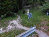 2
2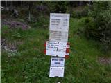 3
3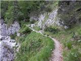 4
4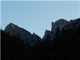 5
5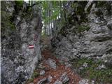 6
6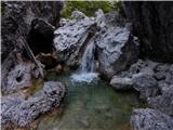 7
7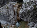 8
8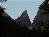 9
9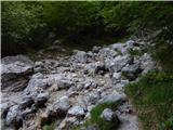 10
10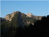 11
11 12
12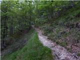 13
13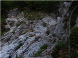 14
14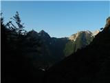 15
15 16
16 17
17 18
18 19
19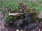 20
20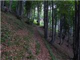 21
21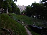 22
22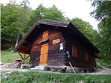 23
23 24
24 25
25 26
26 27
27 28
28 29
29 30
30 31
31 32
32 33
33 34
34 35
35 36
36 37
37 38
38 39
39 40
40 41
41 42
42 43
43 44
44 45
45 46
46 47
47 48
48 49
49 50
50 51
51 52
52 53
53 54
54 55
55 56
56 57
57 58
58 59
59 60
60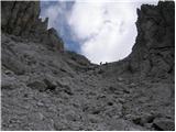 61
61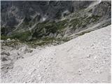 62
62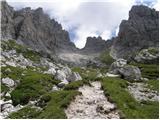 63
63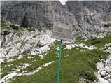 64
64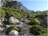 65
65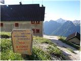 66
66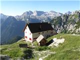 67
67