Budinci (mejni prehod) - Határkőpark
Starting point: Budinci (mejni prehod) (335 m)
| Latitude/Longitude: | 46,87243°N 16,25978°E |
| |
Walking time: 1 h 40 min
Difficulty: easy marked way
Elevation gain: -30 m
Elevation difference along the route: 75 m
Map: Pomurje 1:40.000
Recommended equipment (summer):
Recommended equipment (winter):
Views: 100
 | 1 person like this post |
Access to starting point:
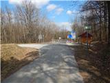
From the road Murska Sobota - Hodoš, in the settlement Šalovci a little after the gas station Ina, we turn left in the direction of Budinci and Dolenci. When we get to Dolenci from the crossroad we continue left, and after the bus stop we go right on a side road. Next follows some descent, and after the transformer we cross the stream Dolenski potok and from the crossroad after the bridge we go left. Further, we stick to the main road, where we go past a cross and chapel, and then also through the hamlet Petešin Breg to the national border, where we park at an appropriate place.
Route description:
From the border crossing, where we notice signs for the path "Pout po dolaj pa bregaj," we continue right towards the east, where we walk on the path that runs by the border stones. The path initially leads through the forest, and soon on the left side we bypass a pasture, and behind it we return to the forest and follow the Hungarian blazes. When we slightly descend, we reach a marked junction, from which we continue straight (left Andovci / Orfalu, right Dolenci). Further on, we mostly walk through the forest, and the path later temporarily crosses entirely to the Hungarian side of the border, where we still follow the blazes. The path ahead returns to the national border, crosses a few more smaller stream beds, and brings us to the historical park Határkőpark.
The description refers to conditions in February 2024, with pictures from March 2021 and February 2024.
Photos:
 1
1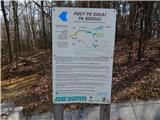 2
2 3
3 4
4 5
5 6
6 7
7 8
8 9
9 10
10 11
11 12
12 13
13 14
14 15
15 16
16 17
17 18
18
Discussion about the trip Budinci (mejni prehod) - Határkőpark
To post a comment you must log in:
If you do not yet have a username, you must first
register.