Central entrance into NP Paklenica - Vaganski vrh
Starting point: Central entrance into NP Paklenica (90 m)
Time of walking: 6 h 30 min
Difficulty: easy marked way
Difficulty of skiing: no data
Altitude difference: 1667 m
Altitude difference (by path): 1725 m
Map: Paklenica, 1:25.000, l.2011, 50 kun
Access to starting point:
After the bridge Maslenički most we leave the highway, which runs forward towards Dalmatia. We are looking for the sign for Starigrad Paklenica (approx. 7-8 km from the highway). In this settlement, we follow brown signs with the caption NP VELIKA Paklenica (not on the first one, that is Mala Paklenica). To the asphalt parking lot leads the road. The entrance into NP Paklenica is payable, last time it was 40 kunas per person, the car is probably included in this price, because we didn't pay it separately. You are on 90 meters above the sea! Surprisingly high, would say!
Path description:
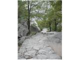
Start at the parking lot NP Paklenica, the path ahead is paved with rocks and it is rising in zig-zags. We all the time walk below the climbing areas. This part of the path is simply named Klanci. We come to a crossroad, where one path runs further towards the mountain hut Paklenica, and the second path turns right on famous climbing wall Anića kuk. To here we need a little less than an hour.
From the crossroad further we follow the path and signs for mountain hut Paklenica. During the ascent, it is possible to turn towards the cave Manita peć, from the path it is distant 45 more minutes. And we continue towards the mountain hut. It is possible that during the walk surprises us some donkey, that the keeper of the mountain hut leads into the valley to get food and supplies and then loaded back to the hut! The mountain hut is located at an altitude 480 meters, but we with the husband when we come got the feeling, that this is more "private" thing, so we went ahead, towards 5 minutes of walking distant Ramići. It was worth it! From Ramići ahead runs classic mountain path. After ten minutes we notice three signs for three possible directions. One is Lipa staza - it is direct, steep, runs in zig-zags, at first a little through the forest and then on gravel / scree and in the summer it isn't very recommended for the ascent. You can choose between two more, namely between path Bukova staza, which in the upper part runs past so-called lake Babino jezero, and the third path Lipi brig, which reaches a plateau and the viewpoint Buljma at 1394 meters and Bivouac Struge at 1410 meters. We chose this path. The path leads through the forest, at first moderately, and then it starts ascending steeper and steeper. During the ascent, there are some turn-offs and shortcuts, but blazes are reliable. Part of the footpath Lipi brig towards Buljma, named Perina greda, was demined. Our path meets the path which brings us here from Velika Gospa and from V. Golić and from Buljma. Krajni brig is a juncture of those paths. Geographically this part is named - Brezimenjača. Earlier we can notice steeper ascent, and from here further start zig-zags, which in the summer heat can be very annoying. Besides this, we cannot exclude some mountain bikers! I have to warn, that on this described path there isn't any water, so you have to take enough of it for seven-hour tour - in one direction! Altitude difference here is the same as if we go from Vrata on Triglav in one day up and back! Well prepared mountaineer = pleased mountaineer!
Buljma is a plateau terrain, but it is also the first serious point, from which, if it isn't too foggy, for the first time a nice view widely opens up on the coast and surrounding peaks. This is a very nice space for a rest and a snack. From Buljma further, the path runs past the bivouac Struge, which we bypassed, around Marasova gora to Marasovac, this supposed to be a source of water, but it is almost impossible to get because of hot and dry summer. After that, the path turns around Marasova gora and it starts again ascending. We have to ascend for approx. 300 more altitude meters from 1400 meters to 1700 meters. In one hour and a half, we reach the crossing, where comes the path from the lake Babino jezero, which is from the crossing distant about 15 minutes. And from here we for the first time see out destination. It is distant about an hour of walking. From 1700 meters we descend to survey point 1634 meters, this is a small saddle, from there we ascend on one more hill, we descend down and in few turns, we finally ascend on 1757.5 meters (this is survey point from the map!) - Vaganski vrh! On the top we get greeted by a cross and a nice view.
We descended on the path Lipa staza, so the steep one, which I described at the beginning. We descend on the ridge towards the southeast, we follow the blazes and signs, which are great the entire path. At first, a shorter ascent follows, after we already thought, that we are already past this, and after this follows quite fast descent, which will be in pleasure mainly for those, who like to run on the scree. The bottom part of the scree is already partly in the forest, therefore the scorching sun will be an alleviated a little by shade. The path comes out at those three signposts, which at the beginning I described as directions of paths, which lead on Vaganski vrh. From here we have 10 more minutes to deserved refreshment at Ramići and a little less than two hours of moderate walking to the parking lot. So, technically looking the tour is otherwise EASY, but because of its length, it is very strenuous, also because of all the food and drinks you have to carry with you. So, you have to start very early, still before the dawn - e.g.. 4:30, so that before the peak you avoid the worst heat. We had 35 degrees in the middle of September. And we wish you a lot of beautiful experiences!
On the way: Anića kuk (711m),
Vaganski vrh (1757m), Babin vrh (1738m), Buljma (1394m), Ramići (520m), Babino jezero (1520m)
Pictures:
 1
1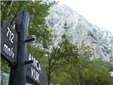 2
2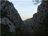 3
3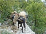 4
4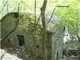 5
5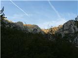 6
6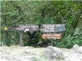 7
7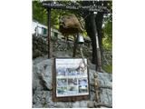 8
8 9
9 10
10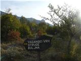 11
11 12
12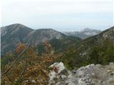 13
13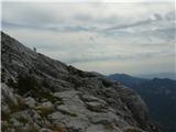 14
14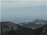 15
15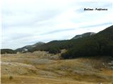 16
16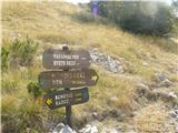 17
17 18
18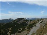 19
19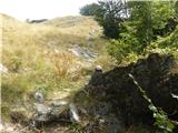 20
20 21
21 22
22 23
23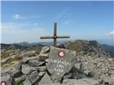 24
24 25
25 26
26 27
27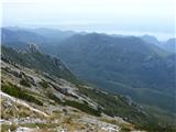 28
28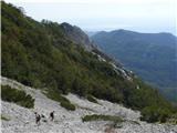 29
29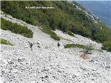 30
30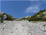 31
31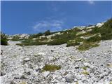 32
32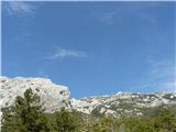 33
33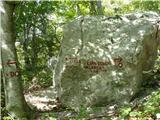 34
34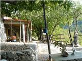 35
35 36
36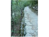 37
37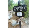 38
38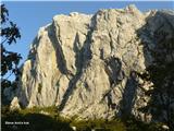 39
39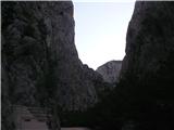 40
40