D postaja - Prestreljenik
Starting point: D postaja (2202 m)
| Latitude/Longitude: | 46,33260°N 13,53840°E |
| |
Walking time: 45 min
Difficulty: partly demanding marked way
Elevation gain: 297 m
Elevation difference along the route: 297 m
Map: Julijske Alpe - zahodni del 1:50.000
Recommended equipment (summer):
Recommended equipment (winter): ice axe, crampons
Views: 40.880
 | 5 people like this post |
Access to starting point:
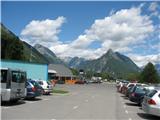
From Kranjska Gora via Vršič Pass or past Rateče to Italy and via Predel Pass we drive to Bovec, or a little further along the main road to the lower station of the Kanin cable car. From the Primorska side, we first drive to the valley of the Soča River and then through Tolmin and Kobarid arrive in Bovec. The price of a return cable car ticket is 13 € (July 2009). In the summer season (July, August) it runs every full hour, starting at 7 a.m. The last ride from D station to the valley is at 5 p.m.
Route description:
A few steps to the right uphill from D station there is a sign "Rombon" on a rock on the ground. We go in this direction to the lower station of the Prevala quad chairlift, beside which we then walk a few minutes to its intermediate station, where at the junction right before it we turn left (straight downhill Rombon and Prevala). The trail runs along a steep slope all the time and is somewhat exposed in places. Considerable caution is needed due to scree on the path, which increases the risk of slipping on steep sections. The path then gradually passes to the eastern side of the mountain, ascends more steeply and becomes somewhat more demanding in places. At a few places one must assist a bit with hands, there are no protections. Just below the summit we encounter the first short fixed cable, which is currently (July 2009) torn off in the lower part, immediately after it the next one, which would probably also need some "service". In this section at one spot a piton is also visible to aid the ascent, but caution – it is not attached but merely wedged between rocks! We ascend the increasingly panoramic slope and after just under an hour of walking reach the summit.
On it stands a miniature copy of the Aljaž Tower, erected by the Slovenian Mountaineering Club Skala. There is a logbook in the turret. The summit is fairly spacious, the views from it very beautiful, as we see everything from the Julian Alps to the Dolomites, Hohe Tauern and the Adriatic Sea.
D station - Sedlo 0:15, Sedlo - via ferrata junction 0:10, via ferrata junction - Prestreljenik 0:20.

Along the route: Sedlo (2284m), Odcep ferate (2364m)
The trip can be extended to the following destinations: Prestreljenik
Photos:
 1
1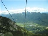 2
2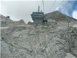 3
3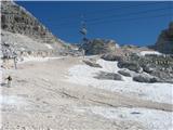 4
4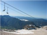 5
5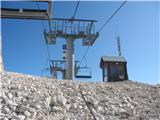 6
6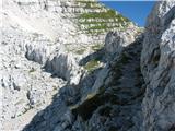 7
7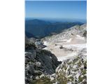 8
8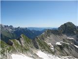 9
9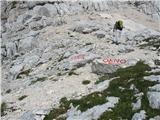 10
10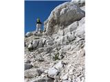 11
11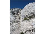 12
12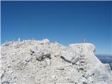 13
13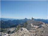 14
14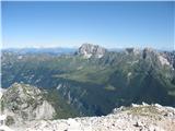 15
15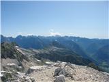 16
16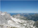 17
17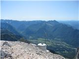 18
18
Discussion about the trip D postaja - Prestreljenik
|
| andrej76730. 07. 2007 |
The tower is really cool, if you photo it from the "right" side you could fool many into thinking you've been to Triglav... 
|
|
|
|
| Snowfreak24. 06. 2008 |
Hi! Tomorrow (25.6.08) we're planning a trip to Prestreljenik. Does anyone know how much snow is left on the path? Thanks and best regards
|
|
|
|
| Klin24. 06. 2008 |
From where are you planning the ascent? If I'm correctly informed, the cable car starts operating on Saturday 28.6.
|
|
|
|
| Snowfreak24. 06. 2008 |
aha... Yes, the plan was from D station. But if the cable doesn't work, we'll probably go somewhere else. From B it's quite long.
|
|
|
|
| mitjasa9. 08. 2009 |
yesterday I was at the summit, and below the summit both cables and the peg are NOT usable. Nicely secured path just below the summit at the besieged window. Lp
|
|
|
|
| petruša23. 08. 2009 |
We went up with 9- and 10-year-old children. The path is very nice. On the return, also go see the window; it's very interesting for children.
|
|
|
|
| damijanp25. 08. 2009 |
Petruša, obviously we vacationed in the same area at a similar time (see also comment at Mangart).
Photos are at:
Prestreljenik
|
|
|
|
| petruša27. 08. 2009 |
we were vacationing in Trenta from 8.8.-17.8.2009, obviously we visited similar mountains suitable for our children, but we also went to Triglav from Zadnjica
|
|
|
|
| damijanp27. 08. 2009 |
We were in Kal-Koritnica from 15. to 22.8. Maybe we'll see each other some other time. 
|
|
|
|
| petruša27. 08. 2009 |
really possible next year, where are you from, we are from the Ormož area
|
|
|
|
| petruša27. 08. 2009 |
from the pictures I saw that you were also at Svinjak, because we were too, and we don't live far from each other
|
|
|
|
| NaaN3. 08. 2012 |
How demanding and time-consuming (I only found information that it should take 3h, which seems unrealistic to me) is the path from station D to Prestreljenik Window? With how old children have you been walking this path?
|
|
|
|
| aljoša112. 06. 2017 |
From the beginning of June onwards, the stamp from Prestreljenik is located at the Bovec TIC.
|
|
|
|
| papillon6. 07. 2017 |
Has anyone been up there recently, can they tell the condition of the cables and pegs on this trail?
|
|
|
|
| 75'er6. 07. 2017 |
For access to Prestreljenik you don't need any peg or cable.
|
|
|
|
| Mundek20. 07. 2020 |
The Prestreljenik stamp is located in the Ski Bum bar on Kanin (at the gondola). Today I visited Prestreljenik and got the stamp there. Regards
|
|
|
|
| Berstuk4. 08. 2020 |
Why is the stamp still in the TIC? It's sad to see the broken tower at the top :/
|
|
|
|
| nrhnrh10. 08. 2020 |
From the intermediate station of the Prevala chairlift, follow the signs for the via ferrata to the sign indicating the start of the via ferrata and its difficulty. Continue right on the marked path there!
No other signs for Prestreljenik were noticed. The via ferrata sign misled quite a few people who were looking for another path. Some of them even went off-trail.
|
|
|
To post a comment you must log in:
If you do not yet have a username, you must first
register.