Dom pod Storžičem - Storžič (via Škarjev rob)
Starting point: Dom pod Storžičem (1123 m)
| Latitude/Longitude: | 46,35860°N 14,39060°E |
| |
Route name: via Škarjev rob
Walking time: 3 h 5 min
Difficulty: difficult marked way
Elevation gain: 1009 m
Elevation difference along the route: 1015 m
Map: Karavanke - osrednji del 1:50.000
Recommended equipment (summer): helmet
Recommended equipment (winter): helmet, ice axe, crampons
Views: 217.898
 | 14 people like this post |
Access to starting point:
First we drive to Tržič, then continue driving towards Dovžanovi soteski and Lom pod Storžičem. At the end of Tržič, near the Lepenka factory, we leave the main road towards Dovžanovi soteski and continue right towards Lom pod Storžičem. Above Lom pod Storžičem we reach the village Grahovše, but we follow the road towards Dom pod Storžičem. After approximately 7.7 km driving from the junction at the Lepenka factory, of which 3.7 km is macadam, we arrive at the parking lot near Dom pod Storžičem, where we park.
Route description:
From the starting point we continue towards Storžič, Tolstega vrha and Kriška gora and take the first steps along the road by which we arrive at the lower edge of Planina Jesenje. Here a marked path to Javorniški preval branches off to the left, slightly to the right the road continues by which we can reach Mala Poljana, but we continue straight along the left edge of the pasture towards Storžič. After a short ascent we reach a wooden hut, where we continue left into the forest (straight Mala and Velika Poljana and Tolsti vrh).
The path ahead leads us along a cart track from which soon to the right a very demanding path through Žrelo branches off, but we continue straight towards the path over Škarjev rob. Further the cart track becomes steeper, higher it changes into a fairly steep mountain path. The path then initially mostly ascends through the forest, higher it thins out several times and the path offers us beautiful views reaching to Triglav. A traverse ascent to the left follows, then at an altitude of about 1700 meters we arrive at a marked junction where the path from Javorniški preval joins us from the left.
We continue right, then traverse upwards along the western slopes of the Škarjev rob ridge, from where we have a nice view towards the path ahead and Storžič. Higher the path brings us to the mentioned ridge from which we also get a view of the Jezersko side where we can nicely see the highest peaks of Kamniško Savinjskih Alp. We then ascend through a belt of scrub, then cross screes where in early summer we can still encounter snow patches. An ascent along the edge of the scree follows, then we reach the technically more demanding part of the path where we first cross a slightly exposed gully (if it is under snow there is a high risk of slipping without using winter equipment), then we ascend a steep valley which is exposed to falling rocks. In the upper part of the valley fixed protections assist us, the path then turns somewhat to the right. Another approximately 10 minutes ascent on a fairly steep slope follows and the increasingly panoramic path brings us to the top of Storžič.
Starting point - Planina Jesenje 0:05, Planina Jesenje - Škarjev rob junction 1:30, Škarjev rob junction - Storžič 1:30.

Along the route: Planina Jesenje (1137m), Razcep nad Planino Jesenje (1150m), Razpotje Škarjev rob (1670m)
Photos:
 1
1 2
2 3
3 4
4 5
5 6
6 7
7 8
8 9
9 10
10 11
11 12
12 13
13 14
14 15
15 16
16 17
17 18
18 19
19 20
20 21
21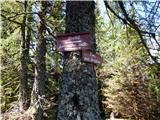 22
22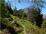 23
23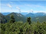 24
24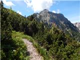 25
25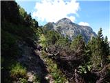 26
26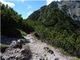 27
27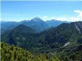 28
28 29
29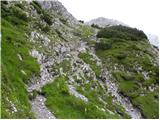 30
30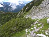 31
31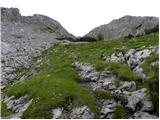 32
32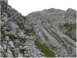 33
33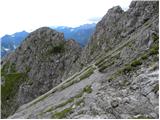 34
34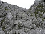 35
35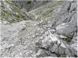 36
36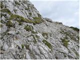 37
37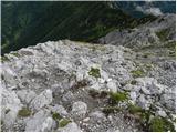 38
38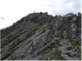 39
39 40
40
Discussion about the trip Dom pod Storžičem - Storžič (via Škarjev rob)
Show older messages
|
| Gost12. 07. 2006 |
9.7.2006
The path is beautiful, as blooming flowers accompany us throughout the entire journey and there is no snow either.
|
|
|
|
| brane13. 07. 2006 |
12.7.2006 The tour over Žrelo is fantastic. Well secured and picturesque route is a real pleasure. At the top of Žrelo, a unique view of the Kranj region awaits you. The path further is very beautiful and you quickly reach the summit. From the hut to the summit 2.30h.
|
|
|
|
| Gost17. 07. 2006 |
17.7.2006. We also went to Storžič over Žrelo. To experienced hikers, this path can really seem fantastic, but for me, it was a bit tight at heart here and there on the ridge. On the way, we saw a lot of flowers, including edelweiss, and on one of the meadows, chamois were grazing. Responsible parents had their children appropriately secured, but one six-year-old went up with his mom even without a helmet (!!!). Can you imagine ??? We also had a 6-year-old boy with us, of course with proper securing. We walked very slowly, so we used twice the predicted time for the ascent. We returned to the car over Škarjev rob.
|
|
|
|
| markol20. 07. 2006 |
19.7.2006
Yes, it's really nice, but I was a bit hot. I was somewhat late, so I hurried a little (over Škarjev rob 2 hours). At the top, there was annoying insects, which there were really a lot of. I have to mention the really friendly staff in the hut under Storžič.
|
|
|
|
| Gost22. 07. 2006 |
the jota in the hut is the best
|
|
|
|
| Gost27. 07. 2006 |
A better variant seems to be the ascent through Žrelo and return through Škarjev rob - nice circular tour.
|
|
|
|
| andreja8@hribi.net18. 08. 2006 |
18.8.06. We had foggy weather, the path through the gorge was quite slippery. We needed 2 hours and 15 min to the top. We returned via Škarjev rob. It was a nice tour.
|
|
|
|
| Gost24. 10. 2006 |
Has anyone been up there recently? I'm heading out on Saturday and I'm curious about the conditions on both routes?
Thanks
|
|
|
|
| Gost25. 10. 2006 |
Both paths are dry. In case of fog, I advise against the path through Žrelo as it then becomes quite wet and slippery. Through Škarjev rob there are no major issues, only in the lower part the orientation is somewhat more difficult due to a lot of leaves on the ground. Plp
|
|
|
|
| Gost3. 11. 2007 |
What's the condition like these days on Storžič? Is there snow already?
|
|
|
|
| Gost4. 11. 2007 |
Very little snow, none at the top anymore, possibly still some on the path through the Škarje but I think the path is safe enough.
Best regards and good luck
|
|
|
|
| Silence26. 01. 2008 |
Ascent along the southern slope, which proved a very good route since the snow held and nothing sank. Avalanche danger in this section is over. Return via Škarjev rob, snow is frozen, where there's a track it's mushy, so great caution needed. Weather 1A, just a bit windy on top. Lp
|
|
|
|
| NEIC00820. 09. 2008 |
In my opinion, the shortest and easiest path to Storžič. For an average hiker, max. 2 hours.
|
|
|
|
| Kriška20. 09. 2008 |
I think the easiest ascent is from Kališče, via Škarjev rob is still a bit more demanding.
|
|
|
|
| mirccar3. 08. 2009 |
On Sunday I would go with my wife from the hut under Storžič (via Škarjev rob) to Storžič, so I'm interested if there's still any snow and of course what the conditions on the path are like!
Regards, Miran
|
|
|
|
| spy3. 08. 2009 |
No more snow on Škarjev rob. Not even a sample. I went there a week ago. It's also possible to go via Žrelo.
Good luck!
|
|
|
|
| sirob4. 08. 2009 |
Tomorrow we plan to go to Storžič via Škarjev rob and I'm curious about the conditions after heavy rain. Thanks!
|
|
|
|
| mojcabreda25. 09. 2009 |
I went up Storžič via this path on Thursday 24.9.2009. Beautiful weather, few hikers. The path is well marked and in good condition. Take advantage of the nice autumn weather...
|
|
|
|
| apovalej25. 02. 2011 |
Today's attempt on this path didn't work out
Too strenuous and too dangerous, my predecessor gave up after 1h from the hut under Storžič.
I also gave up after some trudging , and you still don't know exactly where the path is , and you still don't know exactly where the path is ! Need to take another path to the top. ! Need to take another path to the top.
|
|
|
|
| griček20. 04. 2011 |
Does anyone have current snow conditions on Storžič? We plan to go from Dom pod Storžičem or via Kališče.. Thanks!
|
|
|
|
| nata2420. 04. 2011 |
Via Kališče it is dry, on the other side there is still snow.
|
|
|
|
| hohohodec13. 05. 2011 |
Tomorrow going to Storžič. Is there still snow over Škarjev rob? Thanks!
|
|
|
|
| @rekar13. 05. 2011 |
I recommend crampons to you; in the fifth gully there is still quite a bit of snow.
|
|
|
|
| hohohodec13. 05. 2011 |
Still here and will say once more: thanks!
|
|
|
|
| nejc2914. 05. 2011 |
Towards the top of Škarjeva pot, when the scree fields start, winter gear is still mandatory (at least ice axe and winter boots and helmet!!!) Barbi and I witnessed an unpleasant slip of two hikers a good 20 m!!! Careful
|
|
|
|
| ZOJA27. 06. 2011 |
Yesterday we went up Storžič via the mentioned path. No trace of snow, great views even though it was cloudier. At least the sun wasn't beating on our heads. Up and down took four and a half hours, at Dom pod Storžičem ate excellent wild garlic soup and sausage in wine sauce. Super!
lp
|
|
|
|
| el rocco28. 08. 2011 |
With my wife and younger daughter, we went yesterday for the first time to Storžič. Regardless of the impressive and respectable view of the mountain from the hut under Storžič, the path is unique. First a bit through the forest, then along the ridge and finally a little easy climbing. I also liked that except for what I think are two spots there is no real abyss where you can fall (and even there you're quickly past) . Personally, I would recommend a helmet for the last half hour of this tour.
|
|
|
|
| ANČIKA13. 09. 2011 |
Please, can someone tell me where to go so that in one day I go from Dom pod Storžičem, past Velika and Mala Polaba and planina Javornik to Storžič. Is that possible, is there such a path? Thanks in advance for the explanations!
|
|
|
|
| otiv14. 09. 2011 |
@ANČIKA
From Dom pod Storžičem go towards Tolsti vrh and to planina M. Poljana, where you turn towards planina V. Poljana and continue to planina Javornik and then to Vrh Storžiča. From the summit return via Škarjev rob back to the starting point. Paths to Storžič are all quite steep and require caution.
Good luck!
|
|
|
|
| Jure8715. 09. 2011 |
On Saturday (10.09.2011) I went for the first time to Storžič via this trail (over Škarjev rob) and I must say that both the trail and the mountain were the most beautiful so far for me personally.
In three hours (moderate hiking with a slow snack) you hike a very varied trail:
First a friendly path through the forest (not too steep and winding), then the forest transitions to a meadow with sparsely scattered trees and bushes, the trail becomes gentler and continues like that under the ridge among dwarf pines. Then the pines thin out and the nicest part begins. A view opens towards Jezersko and Grintovci (Kočna), but the trail turns from the ridge onto a short scree and into rocks. Just below the summit there are a few meters of cables (I used it only on the descent) in a steep incline and then after a few 10 meters of slightly less steep trail we are at the top. Along the trail there is a nice view of Julijce, Karavanke, Grintovci and Jezersko. From the top you can also see a large part of Gorenjska.
|
|
|
|
| ANČIKA15. 09. 2011 |
otv
Best thanks for the kindness and the desired description and many more safe steps in the hills.
Good luck and all the best!
|
|
|
|
| mipirkopo4. 10. 2011 |
Today my buddy and I came to Storžič via Žrelo and then descended back via Škarjev rob. Everything nice and fine, just the paths urgently need marking renewal.
|
|
|
|
| hribolazc6. 10. 2011 |
Everything nice and right, but the paths urgently need marking renewal.
+1
|
|
|
|
| soruam14. 10. 2011 |
Tomorrow we plan to go to Storžič. Is there snow via Škarjev rob? Thanks
|
|
|
|
| nata2418. 10. 2011 |
Yesterday afternoon I went down this path and there is still quite a bit of snow, which is frozen and hard. I recommend at least an ice axe.
|
|
|
|
| Domch21. 11. 2011 |
The trail in the upper part and scree is still covered with frozen snow in places and is dangerous for slipping. I recommend at least basic crampons and a helmet. One via ferrata cable is also missing at the end. PD Tržič to action.
|
|
|
|
| planinka eva30. 08. 2012 |
Today I was on Storžič, the trail is very nice and well secured, at the top there's a very nice view  this trail reminds me of the trail to Ojstrica from Korošica this trail reminds me of the trail to Ojstrica from Korošica
|
|
|
|
| lakkon20. 09. 2012 |
hikers, hello.
tomorrow I'm most likely going to Storžič.
I'm interested in:
- if there's any snow on Storžič with surroundings
- if given the rain yesterday (at least where I am in Bela krajina it was quite heavy) the trail is fairly normal
- if I need to pay special attention to anything (in - and + sense) on the circular trail: dom pod Storžičem - Storžič (via Škarjev rob) - Bašeljski preval - dom na Kališču - Široka dolina - Krničarjeva koča - V. and M. Poljana - starting point dom pod Storžičem
thanks for help and nice regards.
|
|
|
|
| andrej7820. 09. 2012 |
No snow, or rather just a sample of it, so cheerfully on the trail!
|
|
|
|
| Primi19. 06. 2014 |
Hi
I'm wondering if there is still any snow on the path to Storžič via Škarjev rob or if the path is completely snow-free.
Best regards.
|
|
|
|
| MONIK11. 07. 2014 |
The trail is completely dry.
|
|
|
|
| nordkap5. 10. 2014 |
hi,
this weekend I would go via this path to the summit and hut, but I'm interested in the conditions, regarding whether any precipitation is expected for this area.
And also, how far is it from the junction where left is Storžič summit and right to the hut. Does the path to the summit go past the hut or do you need to go to the hut first and then to the summit.
Thanks
|
|
|
|
| Miran Matičič7. 10. 2014 |
For the weather check the mountain weather forecast or the nearest location. If you mean Dom pod Storžičem, from where you park you don't need to go past the hut but go immediately left following the markers and signs.
LP
|
|
|
|
| nordkap8. 10. 2014 |
Thanks MM, just wondering how far it is from the trail markers to the hut, since I also plan to go to the hut, at least for the stamp and tea.
Otherwise, I checked, this weekend from Friday onwards the weather will be better than in summer so yeah, let's go. I also plan Friday Skuta, Saturday Storžič, Sunday not sure yet.
|
|
|
|
| Macesna8. 10. 2014 |
Nordkap, it's 100 meters from where you'll park the car to Dom pod Storžičem. One short uphill on the road. You see the hut from the parking lot. Quite simple. Enjoy!
|
|
|
|
| ds14. 10. 2014 |
Hello. I'm wondering if the path to Storžič via Škarjev rob is still snow-free at this time? I'd like to go on Saturday if the weather doesn't stop me.
|
|
|
|
| tinky14. 10. 2014 |
I don't understand these questions. Where and since when would there be snow on Storžič if there isn't even on higher peaks. Check current conditions, webcams........
|
|
|
|
| _d_14. 10. 2014 |
ds, there's no snow anywhere on this path.
|
|
|
|
| maks5731. 07. 2015 |
A magnificent and highly respectable mountain. My wife and I truly enjoyed the tour; the only negative surprise was the summit itself, which was literally littered with goat droppings.
|
|
|
|
| PINOKIO9. 12. 2015 |
On Saturday, 12.12.2015, my friend and I plan to go along the path over Škarjev rob to the top of Storžič. I'm interested if there's already any snow and if the path is well marked.
Thanks for the reply.
Have a nice day !
PINOKIO
|
|
|
|
| ljubitelj gora9. 12. 2015 |
Mandatory equipment: crampons, ice axe, helmet.
|
|
|
|
| redbull9. 12. 2015 |
Strange that you didn't mention some of your already known word helium.
In short, the northern sides have plenty of snow and you need what the colleague above mentioned.
Good luck
|
|
|
|
| ms_primoz10. 12. 2015 |
helium well you do have a sense of humor too..wauuuu
otherwise you two, not you see, but you two, go somewhere else, because I think you've never gone on the mentioned path before. First visit it in summertime (without snow), then go up in conditions like today...
|
|
|
|
| peterr10. 12. 2015 |
The northern side of Storžič is mostly in shade and quite snowy. At least from afar from opp Košuta it looked like that this afternoon.
|
|
|
|
| redbull11. 12. 2015 |
Ms Primoz your reply is funny.
Will you take me through the gorge,
|
|
|
|
| PINOKIO11. 12. 2015 |
Thanks for the answers, some were useful and my friend and I have given up on the plan. We'll wait for summer and then go up, some answers were just more humorous, nothing wrong with that. Thanks once again to everyone and I wish you safe travels in the mountains, wherever you're headed.
|
|
|
|
| Kranj12. 12. 2015 |
Bravo PINOKIO, smart decision not to go hiking in the mountains in winter conditions if you're not experienced. Don't worry, the mountain will wait for you Best regards
|
|
|
|
| mazo12. 12. 2015 |
PINOKIO
I was on Storžič on 10.12. Up through the gully and down through Škarjev rob. No need for crampons. The path is indeed a bit snowy but not too bad. Caution is of course required. If the weather is good you can go without issue.
|
|
|
|
| zupi17. 12. 2015 |
mazo, would it be possible via Žrelo up and Škarjev rob down this weekend without winter gear?
|
|
|
|
| mazo18. 12. 2015 |
yes it goes without problems, I suggest you go up through Žrelo and down Škarjev rob, you'll make a nice loop
|
|
|
|
| rajko002821. 05. 2016 |
Has anyone tried going from Dom pod Storžičem over Mala Polana to Krničar and then to the summit? If yes, I'd ask for a description and time. Thanks.
|
|
|
|
| Daaam21. 05. 2016 |
40 minutes to M.Poljane then another 15 minutes to V.Poljane.. then about half an hour to Krnicarja and then about an hour and a half to the summit. Descriptions are all up here, just combine two or three trips..
|
|
|
|
| Jani3337. 04. 2017 |
Hi,
Tomorrow I plan to go to Storžič, I'm curious about the current condition of the path via Škarjev rob?
Does anyone know?
Thank you kindly
|
|
|
|
| LidijaJesih7. 04. 2017 |
Still quite snowy, at least a couple of days ago it was completely white.
|
|
|
|
| Jani3337. 04. 2017 |
LIdijaJesih thanks for the reply.
Maybe you suggest going from another side? or which is currently the best option.
Thanks
|
|
|
|
| serznoz7. 04. 2017 |
The southern side is clear of snow to the top. Best to go from Bašelj via the hunting trail or from Povelj over Javornik. Good luck
|
|
|
|
| Jani3337. 04. 2017 |
Thanks for the info
|
|
|
|
| seinfeld4. 11. 2017 |
Today we went up this path with my son, back to Dom pod Storžičem via the southwest gully. Altogether 8.5km in under five hours. The summit was in cloud and cold wind, no views along the path either. The path is quite steep up and down, we took more time for the descent than the ascent. Next time in sunshine.
|
|
|
|
| Tomaz197815. 05. 2018 |
I'm wondering if anyone has recently been to Storžič via this path? What are the conditions like? Thanks and best regards
|
|
|
|
| nteam21. 05. 2018 |
Hi.
Yesterday (20.5.2018) I went down via Škarjev rob.
Still a lot of snow, not only in the gully below the summit, but also on the marked path lower down. The snow is soft, but due to the steepness I would advise against descent without crampons and ice axe (I wouldn't tackle it without gear and would turn back).
Up via Žrelo you step on snow 2x - no problem.
For ascent and descent from Dom pod Storžičem without winter gear, the current option is up through Žrelo, down via SW ridge to the bench, across to Javornik and via Polana to the start.
Best regards!
|
|
|
|
| Frukti14. 06. 2018 |
Does anyone have info on current conditions on this trail? Thanks
|
|
|
|
| nteam14. 06. 2018 |
The marked trail over Škarjev rob is fully dry and passable without issues.
Regards!
|
|
|
|
| Enka14. 06. 2018 |
Comparison of this trail with the one over Kališče? Is the one from Kališče really much more exposed?
|
|
|
|
| michael6614. 06. 2018 |
Where on earth are these two trails even exposed 
|
|
|
|
| Enka14. 06. 2018 |
Well, it depends a bit on how sensitive one is to exposure. It made me dizzy here and there over Škarjev rob, but nothing serious. They told me there's more exposure over Kališče, so I'm asking.
|
|
|
|
| fpetel115. 06. 2018 |
If it went over Škarjev rob, it will go over Kališče too, which I think is easier. It's secured and you can hold onto the pines on the harder section.
|
|
|
|
| jozgol3. 07. 2018 |
Was there yesterday. Nice hike for a quick experience of what the mountains offer. Despite the fog, it was even nicer before the hut.
|
|
|
|
| Hribolazec1235. 08. 2018 |
Excellent hike! With my two comrades we reached the summit after an hour and a half of walking.
|
|
|
|
| Gurankar20. 02. 2019 |
Is the road to the Dom pod Storžičem parking lot drivable?
|
|
|
|
| Daaam20. 02. 2019 |
Writing from memory, but I dare say it is not drivable.
|
|
|
|
| Urbban21. 02. 2019 |
Only with chains. The last kilometer is solid ice. You also need a high car, because the road from the tow is quite damaged in places.
|
|
|
|
| Valgirt slo 11. 06. 2019 |
Hello.... What are the conditions on Storžič from the hut via Škarjev rob..."is there still a lot of snow" We plan for next week...
Thanks and nice hiking greetings...
|
|
|
|
| matejc24. 06. 2019 |
Hi!
Tomorrow I would go via Škarjev rob to Storžič. Is there still any snow?
Thanks for the reply!
|
|
|
|
| legenda24. 06. 2019 |
Check the link from 13.6.19
Best regards
|
|
|
|
| mersudin22. 07. 2019 |
yesterday up this path to summit in about 2 hrs, nice path good views and bit of rock towards top...
SUMMIT shitty and crapped on, real mess, couldn't stand more than 10min...Sheep found themselves a toilet with magnificent view..
|
|
|
|
| djimuzl23. 07. 2019 |
You reached their summit and not the other way around..
|
|
|
|
| lanževica23. 07. 2019 |
Regardless of who reached whose summit... the fact is that the Storžič summit is so "shat" by sheep that there's nowhere to sit... it's been like that for years and obviously bothers others too...
|
|
|
|
| jetamp23. 07. 2019 |
I join @lanževica's statement.
It bothered me greatly and also those hikers who were at the summit. They stamped and retreated to the meadow with comments, which is less shat.
|
|
|
|
| djimuzl24. 07. 2019 |
I suggest to the editor to change the difficulty of the summit based on the latest comments
|
|
|
|
| turbo24. 07. 2019 |
Well, probably not that bad due to sheep droppings that one would need gaiters. Or perhaps?
|
|
|
|
| simon7924. 07. 2019 |
Not that bad (for gaiters), but for sandals yes. Indeed quite soiled, but you just step a couple of meters aside to the clearing and it's fine, after all we're in nature and not on Bavarcu. Personally, I prefer Storžič summit with all its ground and smell to the center of Ljubljana. LP and happy hiking.
|
|
|
|
| Lazo28. 05. 2020 |
This path to the summit is really great. There's very very little snow and you can easily bypass it.
Here I'm also posting a video so you can see if you're capable on this path.
We needed a nice 2.5 hours with stops.
https://youtu.be/p9wN6C9pZDM
LP
|
|
|
|
| pantani129. 05. 2020 |
Great. But the ascent video is, to put it mildly, awful. Just watching it gave me a headache. Lp
|
|
|
|
| Lazo29. 05. 2020 |
pantani1 thanks for the feedback.
I myself am aware that the ascent video is too fast and I'll make sure the next one is better and clearer.
LP
|
|
|
|
| potpodnoge30. 05. 2020 |
Nice shot otherwise, but you have to put yourself in the role of a marathon runner who's in a little hurry to the finish. It'll be better. At normal speed, watching the whole ascent will be quite interesting.
|
|
|
|
| planika_3. 07. 2020 |
Is there still any snow on the path over Škarjev rob? Thanks!
|
|
|
|
| asdf19. 06. 2022 03:05:37 |
At the end of the gravel road there is a sign prohibiting traffic in both directions.
|
|
|
|
| zupantomaz9726. 07. 2022 22:06:07 |
On 25.7. when I parked at the hut, they were renovating it. In addition, wood harvesting was taking place, so it's possible that the prohibition sign is intended to keep the works undisturbed.
|
|
|
|
| Tajka678. 10. 2022 13:20:19 |
Just back from Storžič. Wonderful day, exemplary marked trail, food 1a at the hut below! A bit below the summit where there are two ropes one piton has been pulled out, but that doesn't make the path more dangerous. In short, it was worth getting up in the middle of the night
|
|
|
|
| michael669. 10. 2022 06:47:34 |
What is the condition of the road to the hut like?
|
|
|
|
| cofka9. 10. 2022 08:45:54 |
Gravel. Slowly and in first gear
|
|
|
|
| BanAna2116. 04. 2023 17:47:51 |
We're planning a trip to Storžič next weekend, is it safe, can we get up without crampons etc.?
|
|
|
|
| garmont16. 04. 2023 18:33:12 |
Without winter gear it won't be possible.
|
|
|
|
| Deki4. 05. 2024 09:09:50 |
Hello, is there any path suitable for a medium-sized dog? Which path has the longest period without snow and approximately from when to when? Thanks
|
|
|
|
| M E S A3. 06. 2024 19:13:16 |
Is the path over Škarjev rob already dry?
|
|
|
|
| cofka5. 06. 2024 21:19:46 |
The path over Škarjev rob is ok. But there's still snow in the Petega žrela area. Need to wait a bit more to reach the summit safely😊
|
|
|
|
| ljubitelj gora8. 06. 2024 12:03:06 |
Saw on FB that there's no problem. Also via the climbing route.
|
|
|
|
| JanezAS6. 06. 2025 18:03:28 |
Is there still any snow over Škarjev rob?
|
|
|
|
| garmont6. 06. 2025 21:20:52 |
A week ago I descended here.
One snow flank was still so large that I bypassed it exposed. In my opinion, at least an ice axe is still necessary here.
|
|
|
|
| Slavko18. 06. 2025 07:28:03 |
Hello,
I'm interested if there is still any snow on the Škarjev rob path.
|
|
|
|
| mirank8. 06. 2025 21:51:49 |
Do you have some problems with droopy eyelids? If you had looked just one line higher, you would have seen the answer to the same question.
|
|
|
|
| jprim9. 06. 2025 16:03:42 |
@mirank
Doesn't your comment seem a bit arrogant to you?
LP!
|
|
|
|
| turbo9. 06. 2025 16:25:02 |
More elegant than arrogant
|
|
|
|
| Slavko19. 06. 2025 17:04:04 |
Hello Mr. mirank
I am a long-time mountaineer and wouldn't expect such a response from a true mountaineer. Just a little intermezzo, now we're doing the fifth Slovenian Mountain Trail. In the mountains, it's not elegance but caution and respect for the mountains and hills. My eyelids are fine thank God and my eyesight hasn't failed yet. But it's true, I missed your comment. Lp.
|
|
|
|
| mirank9. 06. 2025 22:03:10 |
usually I don't reply twice, just hope you now know how it is over Škarjev rob
|
|
|
|
| JanezAS10. 06. 2025 07:51:20 |
Thanks "garmont". Tomorrow 11.6. I'll go over the Rob. Just in case I'll take the ice axe.
I agree with Slavko that etiquette of communication and mutual respect is important everywhere, also here on the forum, and especially in the mountains. Mountains temper us, also for the good. That's why they are.
Good luck and best regards to all.
Janez
|
|
|
|
| leziga 10. 06. 2025 23:16:48 |
Today 10.6.2025 I went to Storžič up through Žrelo and down through Škerjev rob. Current conditions on both trails are completely dry, without crossing any snow. That snow field from a week ago has already shrunk so much that the trail goes right under the lower edge of the snow. Therefore, winter gear is no longer needed. Good luck to everyone and steady steps.
|
|
|
|
| JanezAS12. 06. 2025 15:42:26 |
Leziga, good information.
Thanks, best regards and all the best!
|
|
|
|
| miamia10. 08. 2025 14:42:55 |
Is there also paid parking in front of this hut (and how much)?
|
|
|
|
| asdf10. 08. 2025 18:13:05 |
Last time I was there (once in May) it wasn't paid.
|
|
|
|
| S57S22. 09. 2025 10:34:43 |
|
|
|
|
| BP2430. 04. 2026 20:02:20 |
Has anyone been to the summit via Škarjev rob in the last few days? I'm wondering if there's still any snow?
|
|
|
|
| ppegan1. 05. 2026 06:19:51 |
There's still snow on the northern side of Storžič. I don't know what the actual conditions are like over Škarjev rob. But it's not a bad idea to have crampons and an ice axe in your backpack, right?
|
|
|
To post a comment you must log in:
If you do not yet have a username, you must first
register.