end of road on Pokljuka - Triglav (via Kredarica)
Starting point: end of road on Pokljuka (1340 m)
Starting point Lat/Lon: 46.3386°N 13.9045°E 
Path name: via Kredarica
Time of walking: 6 h 10 min
Difficulty: very difficult marked way
Difficulty of skiing: very demanding
Altitude difference: 1524 m
Altitude difference (by path): 1650 m
Map: Triglav 1:25.000
Access to starting point:
From highway Ljubljana - Jesenice we go to the exit Lesce and follow the road ahead towards Bled. In Bled at the traffic lights, the signs for Pokljuka point us to the right. Ahead we drive through Gorje and past the abandoned ski slope Zatrnik to Rudno polje on Pokljuka (large parking lot, barracks and shooting range). From here we continue straight on a macadam road which a little further brings us to a crossroad, where we continue right (left Uskovnica). We follow this road to a parking lot at the end of the road (near are signposts for a mountain pasture Konjščica).
Path description:
From the parking lot, we continue right upward on a cart track in the direction of the mountain pasture Planina Konjščica.. Cart track that at first ascends steeply soon becomes gentle and a bit higher turns into a footpath. Next follows a moderate ascent on the path that is ascending by the stream Ribnica which in the upper part has a watterfall that we can see from the path. Further, the path crosses a well and passes to grazing area of the mountain pasture Konjščica. After few ten strides path crosses the next well and ascends a little to cheese cottage on the mountain pasture.
From the mountain pasture, we continue on a gently sloping meadow slightly upwards to the other side of the pasture.. There path passes into dwarf pines and at first, it starts gently ascending, but then it becomes steeper and steeper. In the last part of the ascent the path from Rudno polje joins us from the right. Only a short climb by the torrent follows to reach the grassy plain Jezerce. Here the path turns left and after few steps it brings us into central area of Triglav national park. Next, we ascend by a well towards Studorski preval. A little higher we cross a torrent and the path turns a little to the right into grassy slopes surrounded by dwarf pines. The path then ascends diagonally to Studorski preval from which a nice view opens up to Bohinj side.
The path ahead at first descends a little and then crosses slopes of Veliki Draški vrh and Tosc with few gentle ascents and descends. Eventually, the path brings us to a grassy south slope of Tosc. Here the path on Tosc branches off to the right, and only few meters ahead, the path from Uskovnica joins from the left. We continue straight, and the path ahead continues crossing slopes of Tosc. The path then in a gentle descent crosses a shorter lane of thin forest and then it brings us on steep slopes. A little further ahead, the path on a carved wide ledge in a gentle descent crosses precipitous slopes of Tosc. Since the path is quite wide it doesn't cause problems (carefully because of falling stones, rockfall in the year 2008). The path then again slightly ascends and it brings us to a crossing, where we continue right in the direction of Vodnikov dom. Next follows approximately ten minutes of walking without large ascents or descents to Vodnikov dom.
From the hut, we continue straight in the direction of Triglav (right upward Bohinjska vratca). The path ahead is moderately ascending and crosses slopes below Vernar. Soon we run into the first steel cable, which helps us pass the short ledge. The path ahead is ascending on the scree and then brings us to a steep rocky jump. A well-secured path on steep stairs brings us to the top of that jump. Next follows few meters of crossing on a steep slope, and then the path brings us on ample slopes near the saddle Konjski preval. We reach it after a short descent.
From the saddle Konjski preval we continue straight in the direction of Kredarica (left Planika, right Krma) on the path which already after few steps it brings us to the next crossing, where we continue left (right Staničev dom). The path ahead is ascending diagonally, and in doing so it crosses larger number of smaller gullies, which crossing isn't demanding. A little further, the path with the help of fixed safety gear crosses some technically demanding spots. After that from the right joins the path from the valley Krma, and only few meters ahead we come to the next crossing, where we continue on the right path in the direction of Kredarica (left Planika). Next follows an ascent towards the mountain hut on Kredarica, which we already clearly see in front of us. After a half an hour of walking from the crossing for Planika we come to the mountain hut on Kredarica, where a view opens up on peaks on the northern side of the valley Vrata.
At the mountain hut, we go towards the glacier in the direction of Triglav. The path at first slightly descends and then in ascent brings us to the beginning of the climbing part of the path. A well-secured path with the help of iron spikes and some steel cables brings us on a ridge, where joins the path from Planika. Ahead we almost unnoticeably cross the peak of Mali Triglav. The path on the ridge is panoramic and in parts very precipitous but it is very well secured. The path on the ridge is mostly moderately ascending, only the last ascent is steeper. Few meters below the summit path branches off to the left downwards towards Stanič shelter, and we continue on the ridge to the top, where we already clearly see Aljaž turret which we reach in few steps.
The starting point - Konjščica 30 minutes, Konjščica - Studorski preval 1:30, Studorski preval - Vodnikov dom 1:00, Vodnikov dom - Kredarica 2:00, Kredarica - Triglav 1:10.
Pictures:
 1
1 2
2 3
3 4
4 5
5 6
6 7
7 8
8 9
9 10
10 11
11 12
12 13
13 14
14 15
15 16
16 17
17 18
18 19
19 20
20 21
21 22
22 23
23 24
24 25
25 26
26 27
27 28
28 29
29 30
30 31
31 32
32 33
33 34
34 35
35 36
36 37
37 38
38 39
39 40
40 41
41 42
42 43
43 44
44 45
45 46
46 47
47 48
48 49
49 50
50 51
51 52
52 53
53 54
54 55
55 56
56 57
57 58
58 59
59 60
60 61
61 62
62 63
63 64
64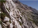 65
65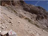 66
66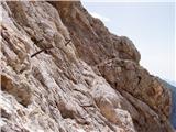 67
67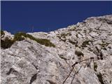 68
68 69
69 70
70 71
71 72
72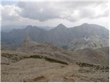 73
73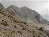 74
74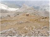 75
75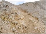 76
76 77
77 78
78 79
79 80
80 81
81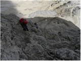 82
82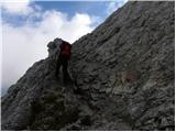 83
83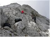 84
84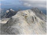 85
85 86
86 87
87 88
88 89
89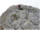 90
90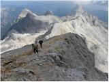 91
91 92
92 93
93 94
94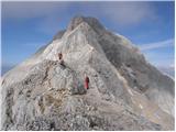 95
95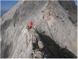 96
96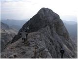 97
97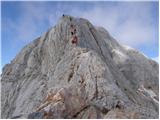 98
98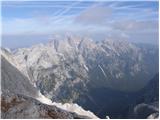 99
99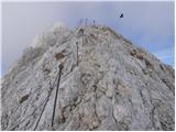 100
100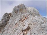 101
101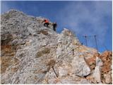 102
102 103
103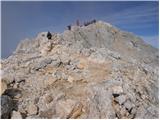 104
104 105
105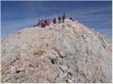 106
106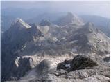 107
107 108
108